

View Information About HSR Ratings
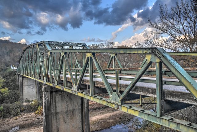
This is a truly unique bridge, with no other similar bridge known to exist. The three span truss bridge consists of what is essentially a pony truss span at each end with a through truss center span. The shape of the trusses gives the bridge a continuous of cantilever appearance. However, the bridge functions as simple truss spans, and the unusually shaped trusses were apparently only built as such to facilitate construction. Looking at the bridge at the ends of the through truss there is a pin, and also empty rivet holes, both at the pin connection and on the adjacent vertical. HAER documentation indicates this bridge was built as a thru truss using cantilever method, with the detail at the pin-connection functioning as a rigid riveted connection enabling construction of the main span via cantilever method thereby avoiding falsework. Afterwards, the riveted connection was removed (explains the empty rivet holes), the pin connection retained, so now the bridge functions as three simple truss spans. Thus, the bridge is not continuous, nor is it a cantilever truss. HAER docs note the bridge was designed by engineers in a single day. If this is true, it seems appropriate to assume this fast turnaround time was made possible because there must have been a state standard Pennsylvania truss and maybe Warren pony truss plan that the engineers must have adapted into this unique design.
![]()
![]()
![]()
This historic bridge has been demolished. This map is shown for reference purposes only.
Coordinates (Latitude, Longitude):
Search For Additional Bridge Listings:
Bridgehunter.com: View listed bridges within 0.5 miles (0.8 kilometers) of this bridge.
Bridgehunter.com: View listed bridges within 10 miles (16 kilometers) of this bridge.
Additional Maps:
Google Streetview (If Available)
GeoHack (Additional Links and Coordinates)
Apple Maps (Via DuckDuckGo Search)
Apple Maps (Apple devices only)
Android: Open Location In Your Map or GPS App
Flickr Gallery (Find Nearby Photos)
Wikimedia Commons (Find Nearby Photos)
Directions Via Sygic For Android
Directions Via Sygic For iOS and Android Dolphin Browser
USGS National Map (United States Only)
Historical USGS Topo Maps (United States Only)
Historic Aerials (United States Only)
CalTopo Maps (United States Only)

© Copyright 2003-2024, HistoricBridges.org. All Rights Reserved. Disclaimer: HistoricBridges.org is a volunteer group of private citizens. HistoricBridges.org is NOT a government agency, does not represent or work with any governmental agencies, nor is it in any way associated with any government agency or any non-profit organization. While we strive for accuracy in our factual content, HistoricBridges.org offers no guarantee of accuracy. Information is provided "as is" without warranty of any kind, either expressed or implied. Information could include technical inaccuracies or errors of omission. Opinions and commentary are the opinions of the respective HistoricBridges.org member who made them and do not necessarily represent the views of anyone else, including any outside photographers whose images may appear on the page in which the commentary appears. HistoricBridges.org does not bear any responsibility for any consequences resulting from the use of this or any other HistoricBridges.org information. Owners and users of bridges have the responsibility of correctly following all applicable laws, rules, and regulations, regardless of any HistoricBridges.org information.
![]()