View Information About HSR Ratings
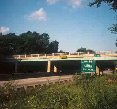
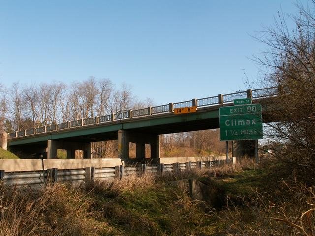
Although not as majestic as a curved t-beam bridge like 6th Street, the original railings on this bridge make it more attractive than most expressway bridges. "Attractive" is a word not often heard when discussing expressway bridges, and so this bridge is a welcome welcome change from the usual. The bridge was built in 1951, as part of the plan for a Detroit-Chicago Expressway, then US-12. It later became I-94 when the Interstate system was created. Unfortunately, this bridge is so old that it was not designed with modern expressway specifications. Near Kalamazoo, I-94 has the smallest allowable number of lanes (two lanes in each direction) yet there is no median of any sort other than concrete barriers, and the 38th Street Bridge was only built to support these four lanes with no median (unlike the curved t-beams like 6th Street which can support three lanes in each direction underneath them. Unfortunately, this means that if a third lane is ever added (which would probably be a good idea) to the very busy I-94, this bridge will end up on the demolition list.
MDOT mentions that this is also known as Scott Road. Although the name Scott Road does not show up on maps, it makes one wonder if Kalamazoo County's roads once had normal names. Many southwestern Michigan counties have a grid-based numbered or lettered naming program for their roads, Kalamazoo County being no exception. In southwestern Michigan, names like East PQ Avenue, 66th Street, and P Drive South are not uncommon rural road names. They are not very attractive names for identifying bridges.
Information and Findings From Michigan Historic Bridge InventoryNarrative Description
Positioned on a north-south axis, the Scott Road Bridge is located southeast of the town of Galesburg in a rural area. The structure is skewed. Railings are standard plan metal panels between concrete posts, terminating at original solid concrete stepped parapet rail ends. This bridge was part of a relocation project for US-12 (now I-94), which was to become the Detroit-Chicago Expressway. This bridge was one of the first built for the Kalamazoo segment of the project. The belt lines or by-passes created by the relocation were an attempt to relieve traffic congestion in the cities along the route. This bridge is one of six in the survey that were part of the relocation project near Kalamazoo. The majority of early expressway bridges, including the others near Kalamazoo, have been altered with concrete parapet replacement railings. As one of the few early expressway bridges with integrity, the Scott Road Bridge is considered historic due to its association with the development of expressways in Michigan. |
This bridge is tagged with the following special condition(s): Unorganized Photos
![]()
![]()
![]()
![]()
Coordinates (Latitude, Longitude):
Search For Additional Bridge Listings:
Bridgehunter.com: View listed bridges within 0.5 miles (0.8 kilometers) of this bridge.
Bridgehunter.com: View listed bridges within 10 miles (16 kilometers) of this bridge.
Additional Maps:
Google Streetview (If Available)
GeoHack (Additional Links and Coordinates)
Apple Maps (Via DuckDuckGo Search)
Apple Maps (Apple devices only)
Android: Open Location In Your Map or GPS App
Flickr Gallery (Find Nearby Photos)
Wikimedia Commons (Find Nearby Photos)
Directions Via Sygic For Android
Directions Via Sygic For iOS and Android Dolphin Browser
USGS National Map (United States Only)
Historical USGS Topo Maps (United States Only)
Historic Aerials (United States Only)
CalTopo Maps (United States Only)

© Copyright 2003-2024, HistoricBridges.org. All Rights Reserved. Disclaimer: HistoricBridges.org is a volunteer group of private citizens. HistoricBridges.org is NOT a government agency, does not represent or work with any governmental agencies, nor is it in any way associated with any government agency or any non-profit organization. While we strive for accuracy in our factual content, HistoricBridges.org offers no guarantee of accuracy. Information is provided "as is" without warranty of any kind, either expressed or implied. Information could include technical inaccuracies or errors of omission. Opinions and commentary are the opinions of the respective HistoricBridges.org member who made them and do not necessarily represent the views of anyone else, including any outside photographers whose images may appear on the page in which the commentary appears. HistoricBridges.org does not bear any responsibility for any consequences resulting from the use of this or any other HistoricBridges.org information. Owners and users of bridges have the responsibility of correctly following all applicable laws, rules, and regulations, regardless of any HistoricBridges.org information.
![]()