HistoricBridges.org Menu: HistoricBridges.org Menu:


We Recommend:
Bach Steel - Experts at historic truss bridge restoration.

HistoricBridges.org: Bridge Browser

Fruitport Road Bridge

Bowen Bridge

Fruitport Road Bridge

Primary Photographer(s): Nathan Holth

Bridge Documented: April 28, 2006

View Photos
and Videos
View Maps
and Links

Facility Carried / Feature Intersected
Fruitport Road Over Petty's Bayou
Location
Spring Lake: Ottawa County, Michigan: United States
Construction Date and Builder / Engineer
1948 By Builder/Contractor: L. W. Lamb Company of Jackson, Michigan and Engineer/Design: Michigan State Highway Department
Rehabilitation Date
2008
Main Span Length
53.8 Feet (16.4 Meters)
Structure Length
418.0 Feet (127.4 Meters)
Roadway Width
24.3 Feet (7.41 Meters)
Spans
9 Main Span(s)
Inventory Number
70200079000B010

Historic Significance Rating (HSR)
View Information About HSR Ratings

Bridge Documentation

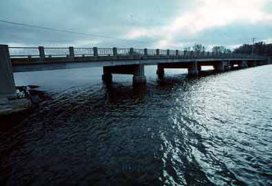
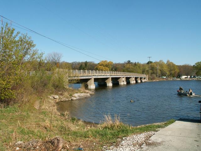
This bridge is a very long example of 1940s beam bridge construction. With original railings, the bridge also retains a high degree of historic integrity. MDOT mentions that the swampy nature of the soil required special support design with this bridge. Indeed, the supports do have an appearance that is unlike that seen in other bridges built during this period. The bridge is in good condition also with weight limits only posted for trucks with more than two axels, 68 tons for three axels, and 47 for more than three axels. This bridge is located at an area that appears to be a popular boat launch for small craft. The bridge creates a nice complement to an attractive region, and should be maintained for its continued historic and functional value.

The bridge was extensively rehabilitated in 2008. Existing beams were cleaned, galvanized, and placed back on the bridge. Two new galvanized beams were also placed at each span. The R4 railing was cleaned and reinstalled as well.

View Archived National Bridge Inventory Report - Has Additional Details and Evaluation

Information and Findings From Michigan Historic Bridge Inventory

Narrative Description

MDOT Historic Bridge Ottawa County Fruitport Rd. / Petty

This multiple-span concrete/steel bridge carries the Fruitport Road over the Pettys Bayou, an arm of Spring Lake, between the villages of Spring Lake and Fruitport. Extending 418 feet in overall length, the Bowen Bridge is comprised of nine steel stringer spans, five at 55 feet in length, two at 53 feet and two at 18 feet. Each span is made up of eight lines of rolled I-beams, with steel channel spandrel beams, all braced laterally by solid steel diaphragms. The superstructure is supported by concrete spill-through piers, each of which rests on two steel caissons.

The bridge's location over a marshy inlet necessitated unusually deep foundations. "The design was dictated by the type of material underlying the lake bottom which provided very low bearing values at depths of over 100 feet below the water surface," MSHD engineer C.H. Voss stated in 1949. "In order to provide satisfactory bearing for the foundation units, the substructure was designed to incorporate the use of friction piling which was provided by the use of tapered, fluted shell piles in the pier units and timber piles in the abutment units."

The Bowen Bridge features standard MSHD design and detailing, with corbelled steps on the bulkheads and concrete piers, ornamental steel guardrails with concrete posts, and a concrete deck that corbels over the spandrels to form stringcourses. Today the bridge is in excellent structural condition, without alterations.

Formed in 1911, the Ottawa County Road Commission immediately began an ambitious program of countywide road and bridge construction, entailing almost 200 miles of roads. One of the routes originally designated by the commission was the Fruitport Road, a 1 1/2 -mile stretch in Spring Lake Township. The commission began actual construction of this and other county roads in the spring of 1912. Under the supervision of County Surveyor Emmet Peck, work progressed throughout the county during the 1910s. In 1921, the commission hired civil engineer Carl Bowen. A former MSHD employee, Bowen was responsible not only for the road and bridge engineering in Ottawa County but for day-to-day operation of the road commission. He held the position for more than three decades before retiring around 1956.

One of the bridges built under Bowen's tenure was this multiple-span structure over Pettys Bayou on the Fruitport Road. The Michigan State Highway Department engineered the structure late in 1947 on behalf of the county. MSHD designated the bridge as a Federal Aid Secondary project, solicited competitive proposals and awarded the contract to build it to L.W. Lamb of Holland, Michigan, and the Luedtke Engineering Company of Frankfort.

Poor bearing conditions dictated an innovative substructural system. According to Voss, "The abutment units are of cellular construction supported on timber piling. This type of construction was selected to reduce the weight on the underlying soil and to spread the bearing over a greater area so as to avoid superimposing loads on the approach fill." The piers were caisson-type over driven piles. Construction on the bridge commenced in February 1948 and continued unabated until a two-week break in July. The last concrete was poured in November; the bridge was opened to traffic on December 3, 1948. Total cost :$237,000.

At the request of the local Chamber of Commerce, the bridge was dedicated on June 24 as the Bowen Bridge. The structure "honors Bowen for his long service to the commission," state the Grand Haven Daily Tribune. "For 27 years he has guided the development of county highways and bridges, virtually lifting most county roads out of literal sand ruts of years ago."

Statement of Significance

The Bowen Bridge has since carried vehicular traffic on this secondary route, in essentially unaltered condition. The Bowen Bridge represented one of the most important pieces of post-WWII construction in Ottawa County. It is historically important for its association with Carl Bowen, a locally important personage. And it is technologically noteworthy as a well-preserved example of late-1940s bridge construction in Michigan.

Divider

Photo Galleries and Videos: Fruitport Road Bridge


View Photo Gallery

Bridge Photo-Documentation

A collection of overview and detail photos. This photo gallery contains a combination of Original Size photos and Mobile Optimized photos in a touch-friendly popup viewer.
Alternatively, Browse Without Using Viewer

Divider

Maps and Links: Fruitport Road Bridge

Coordinates (Latitude, Longitude):

Search For Additional Bridge Listings:

Bridgehunter.com: View listed bridges within 0.5 miles (0.8 kilometers) of this bridge.

Bridgehunter.com: View listed bridges within 10 miles (16 kilometers) of this bridge.

HistoricBridges.org Bridge Browser: View listed bridges within 0.5 miles (0.8 kilometers) of this bridge.

HistoricBridges.org Bridge Browser: View listed bridges within 10 miles (16 kilometers) of this bridge.

2021 National Bridge Inventory: View listed bridges within 0.5 miles (0.8 kilometers) of this bridge.

Additional Maps:

Google Maps

Google Streetview (If Available)

Bing Maps

OpenStreetMap

GeoHack (Additional Links and Coordinates)

Apple Maps (Via DuckDuckGo Search)

Apple Maps (Apple devices only)

MapQuest

HERE We Go Maps

ACME Mapper

Waze Map

Android: Open Location In Your Map or GPS App

Flickr Gallery (Find Nearby Photos)

Wikimedia Commons (Find Nearby Photos)

Directions Via Sygic For Android

Directions Via Sygic For iOS and Android Dolphin Browser

USGS National Map (United States Only)

Historical USGS Topo Maps (United States Only)

Historic Aerials (United States Only)

CalTopo Maps (United States Only)


Divider
 
Home Top

Divider

About - Contact

© Copyright 2003-2024, HistoricBridges.org. All Rights Reserved. Disclaimer: HistoricBridges.org is a volunteer group of private citizens. HistoricBridges.org is NOT a government agency, does not represent or work with any governmental agencies, nor is it in any way associated with any government agency or any non-profit organization. While we strive for accuracy in our factual content, HistoricBridges.org offers no guarantee of accuracy. Information is provided "as is" without warranty of any kind, either expressed or implied. Information could include technical inaccuracies or errors of omission. Opinions and commentary are the opinions of the respective HistoricBridges.org member who made them and do not necessarily represent the views of anyone else, including any outside photographers whose images may appear on the page in which the commentary appears. HistoricBridges.org does not bear any responsibility for any consequences resulting from the use of this or any other HistoricBridges.org information. Owners and users of bridges have the responsibility of correctly following all applicable laws, rules, and regulations, regardless of any HistoricBridges.org information.

Admin Login

Divider