

View Information About HSR Ratings

Please note that this railway bridge is privately owned and is located on private property. Please do not approach or attempt to trespass on the bridge deck.
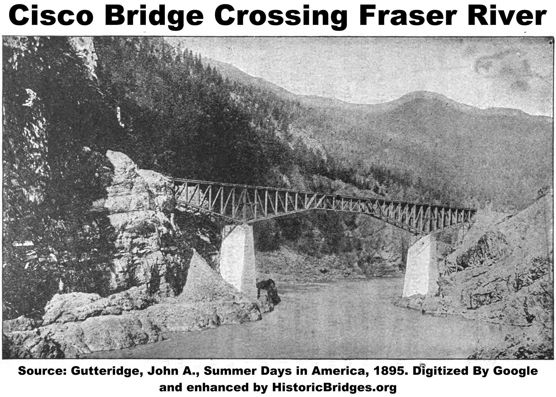
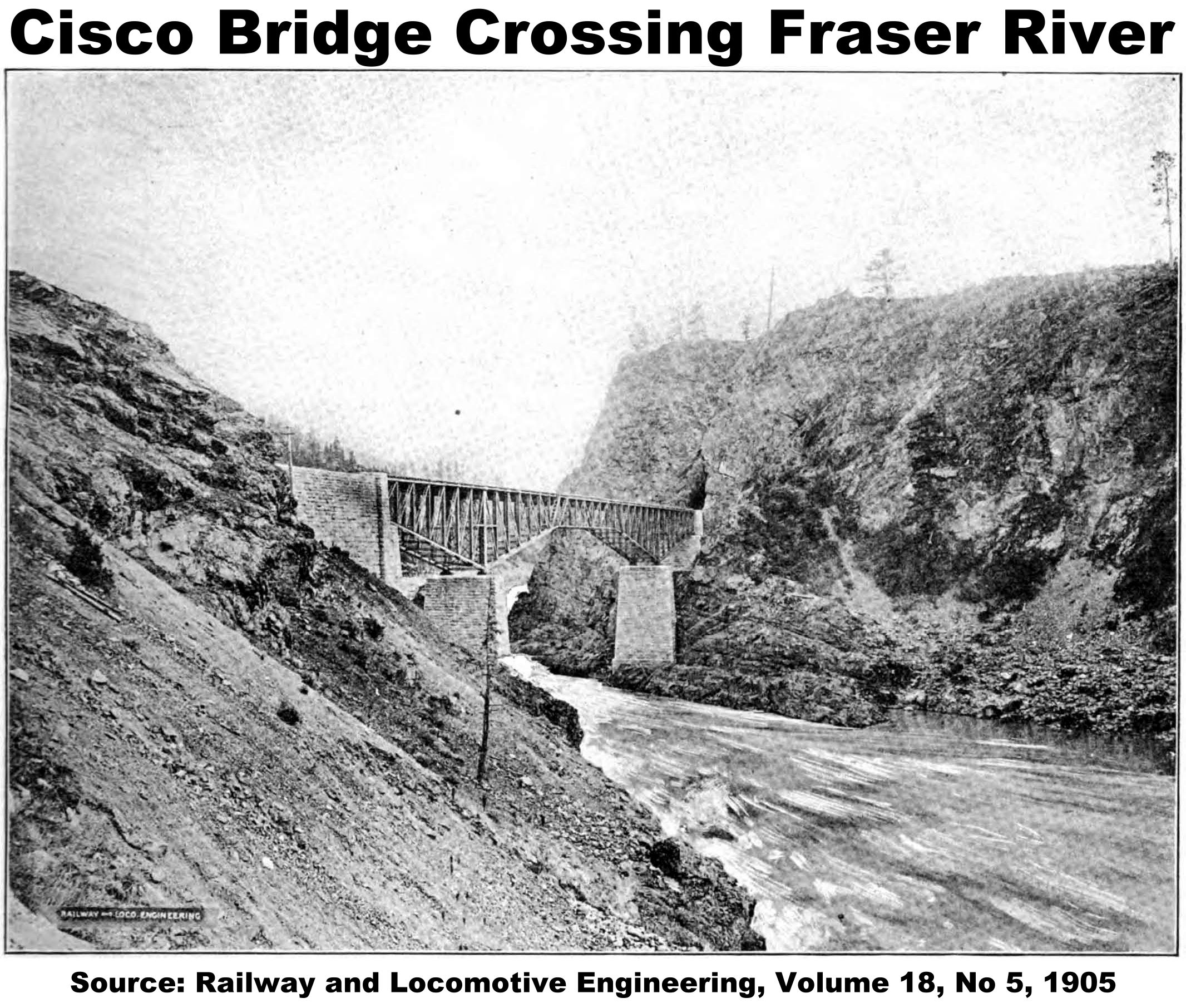
This bridge is a deck truss cantilever bridge that was completed in 1884 to carry the Canadian Pacific Railway over the Fraser River in British Columbia in an area called Cisco. As such, the bridge was known as the Cisco Bridge. According to an 1894 Annual Report of the Department of Railways and Canals of the Dominion of Canada, the bridge was painted white for a time during its service on the Fraser River, which was the same color as other bridges in the railway division.
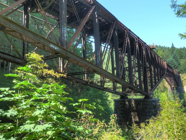
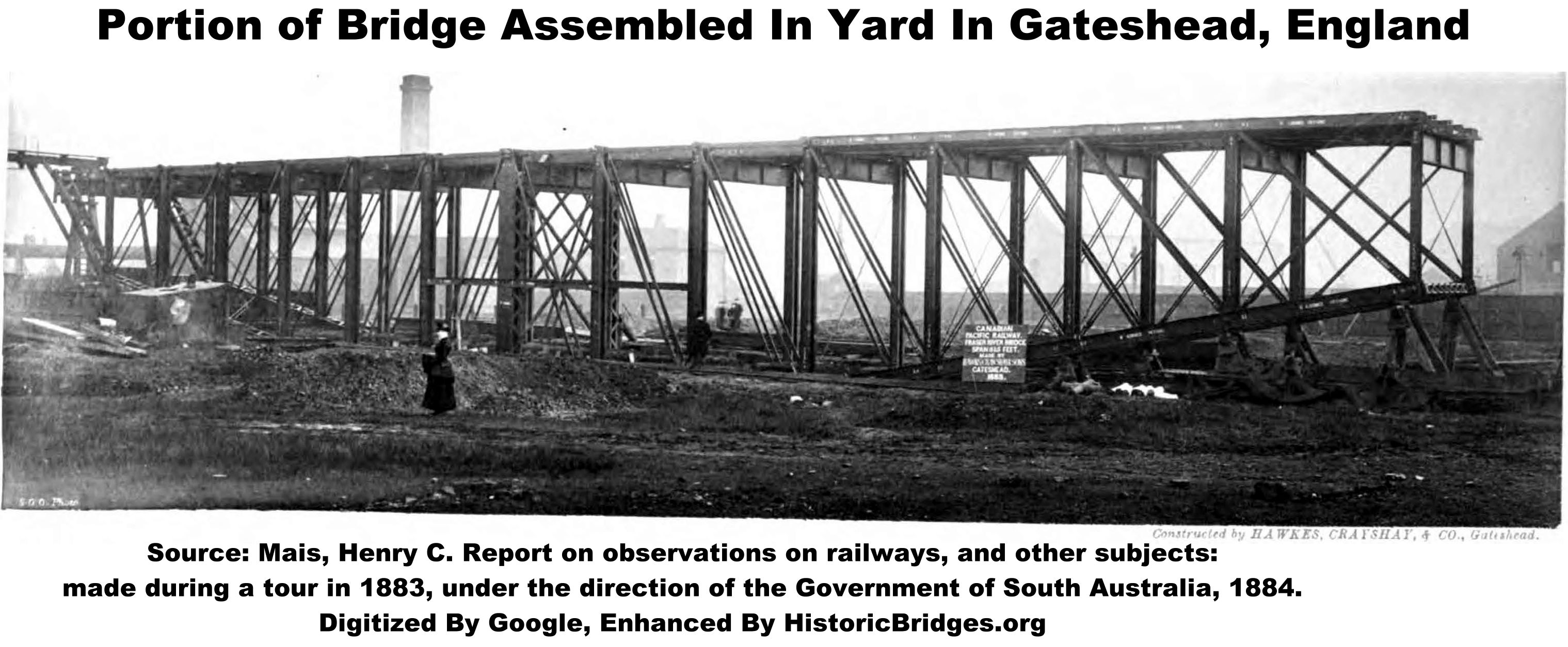
In 1909-1910 the bridge was dismantled, relocated, and reassembled at its current location over Niagara Canyon on Vancouver Island to serve the Esquimalt and Nanaimo Railway, which was also a line of the Canadian Pacific. It has stood there to this day., relocated, and reassembled at its current location over Niagara Canyon on Vancouver Island to serve the Esquimalt and Nanaimo Railway, which was also a line of the Canadian Pacific. It has stood there to this day. When completed, this bridge was among the first cantilever truss bridges to be constructed in North America. This bridge, and the additional small number of cantilever truss bridges which had been built in the world at the time would serve as prototypical models that likely provided the gateway for the design and construction of the many cantilever truss bridges of increasing size that would be built in the years to come.


Above: Bridge in original location as Cisco.

Above: Bridge in original location as Cisco.

Above: This is the bridge as Cisco that replaced the cantilever bridge. Because the replacement bridge was a through truss that reused the existing stone piers, steel extensions had to be added to the two piers to support the through truss design.
This bridge is today located just outside of Goldstream Provincial Park, although the bridge itself and the land immediately around it are private property. Please remain on Goldstream Provincial Park and enjoy the views of the bridge from the park. If you are just driving by and want to make a quick stop at the bridge there are a few things you should know. First, unlike many deck truss bridges, you do not start your walk back to the bridge on the high ground. You start from the bottom of the canyon and must walk a rugged trail up to the deck level of the bridge. Its not a very long hike distance-wise, but it is very steep and primitive in some areas, and constantly going up. You can walk it, but unless you are fit, or enjoy being miserable plan on taking some time to get back to the bridge. Next, to get to where you park, please note that there is an extremely long section of the highway leading before and after the parking lot where you cannot turn around for a very, very long time due to a concrete median barrier. So don't miss the parking lot! If going north, the turn for the parking lot is to the right, and it appears that there is a walkway under the highway. If going south, their is a much smaller and less visible parking lot right next to the waterfall which is near where you begin the hike back, a right hand turn IMMEDIATELY after you cross the creek which is hardly visible from the road. Wherever you park, get to the west side of the highway, walk over the creek, then turn left. If you find yourself at the base of the waterfall, you are in the wrong spot... walk back to the highway and walk along the shoulder across the creek and turn left. The follow the unmarked but heavily walked trail back to the bridge. Along the way back, you will pass by the top of the waterfall, then re-cross the creek. Then, make sure you are generally paralleling the creek as you ascend. Please remain in the park and view the bridge from park property only.


Charles C. Schneider was the engineer who designed the Cisco Bridge. Schneider also designed the somewhat similar Niagara River cantilever truss which was built a year before this bridge to connect Ontario and New York. Schneider would later go on to assist in the design of the second (and successful) Quebec Bridge. Working on these bridges may have given him an early chance to become familiar with the unique aspects of designing and constructing cantilever truss bridges.
The first "modern" cantilever bridge to have been built in the world was the was Hassfurt Bridge (Haßfurter Brücke) over Main River in Germany in 1867. The bridge was the work of Heinrich Gerber and it had a center span of 125 feet (38 meters). Its suspended span was actually a lenticular truss bridge, making this prototypical bridge quite unique in design.
   |
| Heinrich Gerber and his Haßfurter
Brücke, the first modern cantilever truss, built 1867. Source: Portrait: Mehrtens, Georg Christoph. Vorlesungen Über Ingenieur-Wissenschaften, 1908 and bridge photo: Mehrtens, Georg Christoph. Der Deutsche Brückenbau im XIX Jahrhundert, 1900, both digitized by Google. |

The next noteworthy cantilever, and the first in North America, was C. Shaler Smith's Kentucky River Bridge for the Cincinnati Southern Railway built in 1877. This was the world's longest cantilever at the time. It was however an unusual structure, and did not have a traditional cantilever design. In both appearance and design, it was essentially a typical deck truss bridge with a few members and chords removed, which made the bridge function as a cantilever truss with no suspended span. The design appears to have been chosen mainly to allow for better expansion/contraction of the bridge under load and temperature.

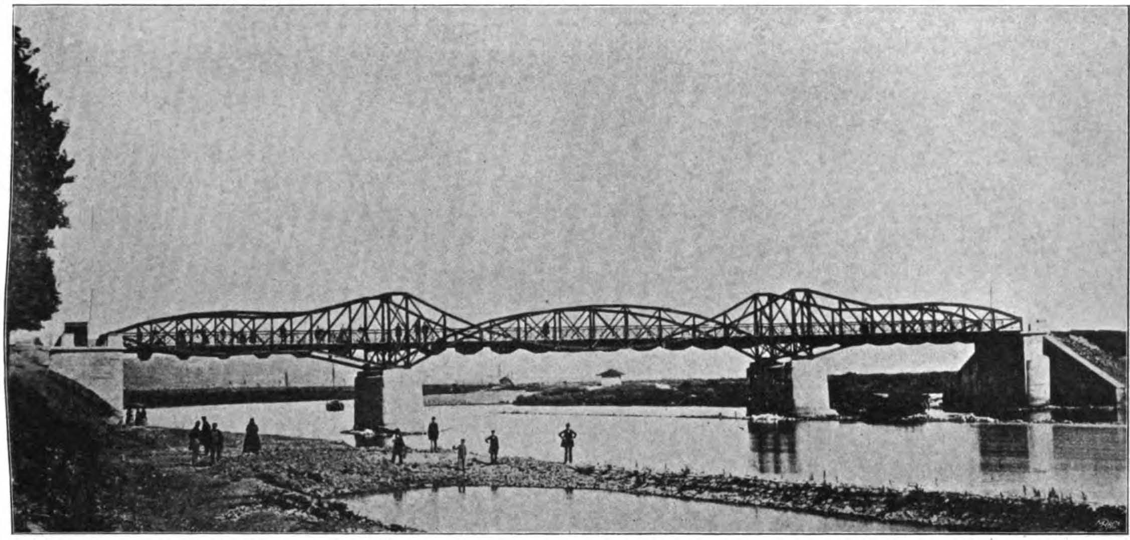
A more traditional cantilever truss, the Niagara Cantilever Bridge, which was erected over the Niagara River at Niagara Falls between New York and Ontario was completed in 1883. It was a cantilever deck truss with two piers supporting anchor arms and cantilever arms, and a suspended span between the cantilever arms. Charles C. Schneider was the designer of the bridge. Read a historical article about it here. For a more detailed discussion, read a detailed discussion by Schneider himself and also view the accompanying image plates and enhanced drawings in this PDF. A year later, the Cisco Bridge, of similar design and appearance as the Niagara River Bridge, was completed, again under the engineering designs of Charles C. Schneider.
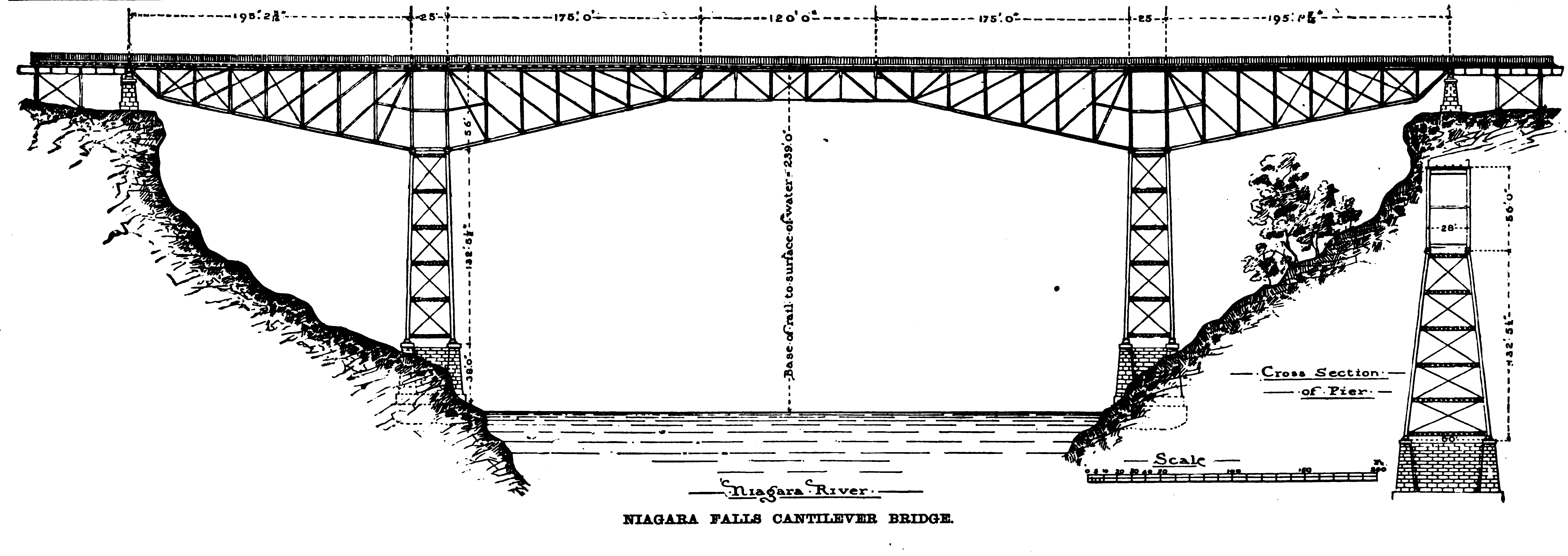 Drawing of the Niagara River Cantilever Bridge at Niagara Falls. Source: Engineering News and American Contractor, Volume 11, 1884 |
Today, both the Kentucky River Bridge and the Niagara River Bridge have been demolished. Therefore, the Cisco Bridge appears to be the oldest surviving cantilever truss bridge in North America. As such, the bridge today is distinguished as one of the most important bridges in North America. Not only does it appear to be the oldest surviving example in North America, it appears to be one of the earliest surviving cantilever truss bridges in the world. As an early cantilever truss bridge, it served as a prototype or model for cantilever bridges built after it. Although it was relocated long ago, the bridge appears to retain integrity of materials and design from the original 1884 construction such that the bridge's significance was not diminished by the relocation.
In May 2011, concerns were raised about a slight sag in the bridge, which has apparently existed since the 1960s but is causing worry among officials today. A bridge typically should have a slight camber to the deck or be level, so the sag would seem to indicate some sort of problem. However if the problem has existed since the 1960s and is not getting worse, it may not be a major issue. It may indicate a settling of the substructure.

The Island Corridor Foundation, who owns the railroad line and bridge today, plans to have an engineering analysis done on the bridge to determine what the condition of the bridge is and what changes might be needed to enable it to continue to carry passenger trains or to perhaps carry some manner of industrial freight as well. A news article said that the foundation does not expect that an analysis would recommend replacement, but commented that if the analysis did recommend replacement that the costs would be significant. This statement does raise some concern. Even though they do not expect to replace the bridge, the phrasing does make it sound like replacement is on the table if need be. If a new bridge is needed, it is absolutely essential that the heritage bridge still be preserved and protected from demolition and/or abandonment at all costs. That could mean building a new bridge on a different alignment and leaving the heritage bridge in place to be restored for pedestrian use. It could even mean relocating the bridge to a new location, just like was done way back in 1909. The significance of this bridge in terms of engineering heritage cannot be understated. Preservation at any cost is a must for this bridge.


![]()
![]()
![]()
Please note that this railway bridge is privately owned and is located on private property. Please do not approach or attempt to trespass on the bridge deck.
Coordinates (Latitude, Longitude):
Search For Additional Bridge Listings:
Additional Maps:
Google Streetview (If Available)
GeoHack (Additional Links and Coordinates)
Apple Maps (Via DuckDuckGo Search)
Apple Maps (Apple devices only)
Android: Open Location In Your Map or GPS App
Flickr Gallery (Find Nearby Photos)
Wikimedia Commons (Find Nearby Photos)
Directions Via Sygic For Android
Directions Via Sygic For iOS and Android Dolphin Browser

© Copyright 2003-2024, HistoricBridges.org. All Rights Reserved. Disclaimer: HistoricBridges.org is a volunteer group of private citizens. HistoricBridges.org is NOT a government agency, does not represent or work with any governmental agencies, nor is it in any way associated with any government agency or any non-profit organization. While we strive for accuracy in our factual content, HistoricBridges.org offers no guarantee of accuracy. Information is provided "as is" without warranty of any kind, either expressed or implied. Information could include technical inaccuracies or errors of omission. Opinions and commentary are the opinions of the respective HistoricBridges.org member who made them and do not necessarily represent the views of anyone else, including any outside photographers whose images may appear on the page in which the commentary appears. HistoricBridges.org does not bear any responsibility for any consequences resulting from the use of this or any other HistoricBridges.org information. Owners and users of bridges have the responsibility of correctly following all applicable laws, rules, and regulations, regardless of any HistoricBridges.org information.
![]()