
View Information About HSR Ratings
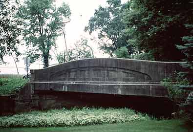
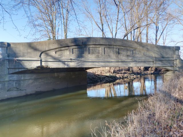
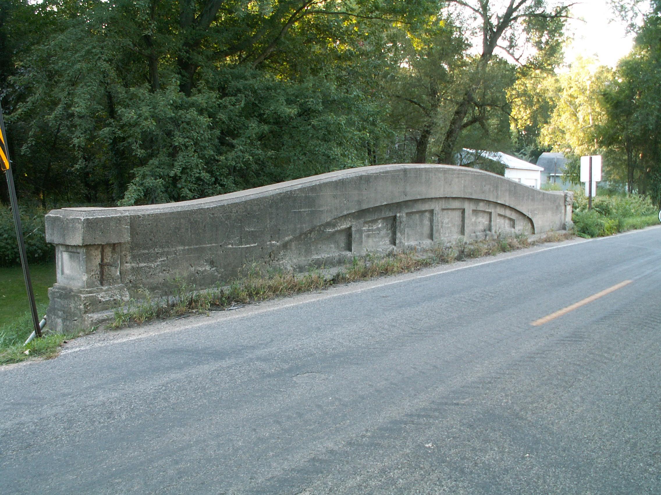
This was a completely different Second Street than the one the truss bridge in Allegan County is on. This bridge was similar in size and style, including its skewed alignment, to the similar bridge a few miles north on this same road. This bridge was extremely significant as a surviving example of a curved chord through girder bridge, commonly called a concrete camelback bridge. A small number of examples remain in Michigan, and only a few states in the entire country ever built any bridges of this type. As such, this bridge type is rare on a statewide and national level. This particular bridge was also significant as being part of a Covert Road, as the plaques on the bridge showed. Read the Historic Bridge Inventory data below for details on the Covert Act. The structure was in relatively good condition, with very little spalling.
With so few remaining examples of this unique and attractive historic bridge type, every effort should be being made to preserve each remaining example. As a bridge associated with an unusual funding program, this bridge was particularly significant. Additionally, the bridge was in decent condition, better than a number of surviving bridges in Michigan. While the road that the bridge was located on was called a "primary" county road, the reported Average Daily Traffic was only 560. This is a very small amount of traffic. The width of the bridge, although narrow for a two-lane bridge compared to modern bridges, was more than sufficient for a quiet county road such as this. Additionally, at 22 feet, this bridge's roadway was wider than many concrete camelback bridges that only have a 20 foot roadway. This was a bridge that deserved preservation. Preservation appears to have been a sensible course of action in terms of the bridge's use and condition.
Despite the above conditions, Allegan County Road Commission made the choice to demolish and replace this historic bridge with a mundane pre-stressed concrete bridge. This is not not only disappointing but is deeply disturbing. It shows a complete lack of interest in the preservation of Michigan's unique historic concrete camelback bridges, even when that preservation is feasible and cost-effective. With so few examples of this bridge type left, each surviving example should be preserved. It is sickening to even think of one of these beautiful historic bridges with a unique appearance that is Michigan's alone would be demolished. These bridges were so heavily overbuilt that their decks have been known to bear heavy loads even after the load-bearing girders are removed. The demolition of this bridge raises serious concerns about the other two concrete camelback bridges in Allegan County. Will the county road commission have a change of heart and choose to commit to the long term preservation of the two remaining examples, or will it choose to annihilate those bridges in the same way, condemning Allegan county to an existence without these beautiful bridges?

Information and Findings From Michigan Historic Bridge Inventory
Narrative Description The Second Street Bridge was built by the Allegan County Road Commission as a covert road bridge in about 1926. The county hired Yost Brothers, contractors from Decatur, Indiana, to erect the structure. The original plans cannot be located, but the design appears to be based on the standard Michigan State Highway Department plan for a curved-chord concrete girder bridge. This structure is a rare example of a bridge with a plate indicating that it was built as part of a covert road. Statement of Significance The Second Street Bridge is eligible for the National Register because it exemplifies the state's pioneering efforts to develop standard plans and implement programs such as the Covert Act. Passed by the state legislature in 1915, the Covert Act required the state, upon request of the appropriate locality, to build all trunk-line roads as well as inter-county non-system roads. Adjacent land owners were assessed for half the cost; road commissions could issue bonds for the remainder. |
![]()
![]()
![]()
![]()
This historic bridge has been demolished. This map is shown for reference purposes only.
Coordinates (Latitude, Longitude):
Search For Additional Bridge Listings:
Bridgehunter.com: View listed bridges within 0.5 miles (0.8 kilometers) of this bridge.
Bridgehunter.com: View listed bridges within 10 miles (16 kilometers) of this bridge.
Additional Maps:
Google Streetview (If Available)
GeoHack (Additional Links and Coordinates)
Apple Maps (Via DuckDuckGo Search)
Apple Maps (Apple devices only)
Android: Open Location In Your Map or GPS App
Flickr Gallery (Find Nearby Photos)
Wikimedia Commons (Find Nearby Photos)
Directions Via Sygic For Android
Directions Via Sygic For iOS and Android Dolphin Browser
USGS National Map (United States Only)
Historical USGS Topo Maps (United States Only)
Historic Aerials (United States Only)
CalTopo Maps (United States Only)

© Copyright 2003-2024, HistoricBridges.org. All Rights Reserved. Disclaimer: HistoricBridges.org is a volunteer group of private citizens. HistoricBridges.org is NOT a government agency, does not represent or work with any governmental agencies, nor is it in any way associated with any government agency or any non-profit organization. While we strive for accuracy in our factual content, HistoricBridges.org offers no guarantee of accuracy. Information is provided "as is" without warranty of any kind, either expressed or implied. Information could include technical inaccuracies or errors of omission. Opinions and commentary are the opinions of the respective HistoricBridges.org member who made them and do not necessarily represent the views of anyone else, including any outside photographers whose images may appear on the page in which the commentary appears. HistoricBridges.org does not bear any responsibility for any consequences resulting from the use of this or any other HistoricBridges.org information. Owners and users of bridges have the responsibility of correctly following all applicable laws, rules, and regulations, regardless of any HistoricBridges.org information.
![]()