
View Information About HSR Ratings
Mill Road is also listed as Avery Road in the National Bridge Inventory and perhaps on some maps as well.
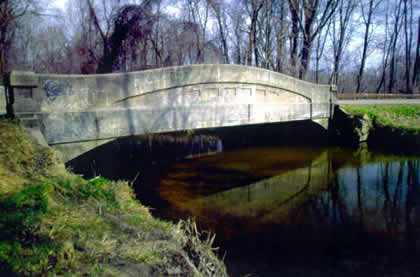
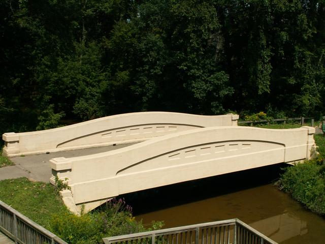
The New Troy Bridge is a gorgeous example of a 60 foot plan curved chord through girder bridge in a scenic location. Most exciting is the fact that this bridge has been preserved in a park setting where it can be enjoyed at leisure, while traffic now crosses on a nearby modern bridge on a new road alignment. In a county where the road commission has managed to obliterate nearly every other historic bridge in the county, a community stepped forward and saved this remaining bridge before it too could be demolished. Michigan has mostly ignored the national significance of each remaining concrete camelback bridge in the state, frequently demolishing the remaining bridges despite their obvious historic significance. These bridges are often needlessly demolished, as owners cite their narrow deck width as reason, ignoring many alternatives to demolition that may exist. The result here at New Troy is an example of one such alternative that is usually ignored that instead was implemented, resulting in a wonderful preservation story. The preservation of this bridge is a major and noteworthy accomplishment.
The bridge is actually almost impossible for northbound traffic on Mill Road to see from the new crossing, but it is there, and well worth a visit. The New Troy Bridge has the distinction of being the first of the small 60 Foot Plan curved chord through girder bridges to be preserved. Just because a bridge is not the largest or the oldest does not mean it has no historic value. Any bridge that has stood for over three quarters of a century certainly has something to contribute to understanding our transportation history. This bridge looks significantly different than the Mottville Bridge for example, although they are the same structural type. Each represents a separate part of our state's history. The Mottville Bridge represents the extraordinary, the largest of the bridge type ever built. The New Troy Bridge represents the mainstream of this bridge design, showcasing the more commonly built shorter spans, like this 60 foot plan design. Each have become rare today, because so many have been ruthlessly demolished, and as such each are historic and more than worthy of any preservation effort. The New Troy Bridge has the added attraction of being a small, quaint bridge that fits well into the small park created around it. Any of Michigan's curved chord through girders offer excellent aesthetic value. The graceful curved design of the bridge, coupled with the simple yet complimentary square designs embossed in the girder form a unique bridge design that is a stark contrast to modern bridges, such as the mundane bridge that currently serves Mill Road next to this historic bridge.
This bridge was built as a State Reward Bridge. Although the plaque no longer remains on the bridge, it was likely similar to that seen on the Yale Road Bridge.
The people of New Troy and Weesaw Township deserve to be thanked for preserving this irreplaceable part of Michigan's transportation heritage. Because of their efforts, future generations will be able to enjoy the beauty and history of this bridge type that played such an important role in the early development of standardized highways in Michigan. This bridge is only four miles from I-94 Exit 12, and as such it is an easy stop for anyone to take a break from driving to Detroit or Chicago or some other place.

Photo Credit: Jason Holloway
Information and Findings From Michigan Historic Bridge InventoryNarrative Description
The Avery Road Bridge is eligible for nomination to the National Register as an excellent example of a 60-foot, curved-chord, through-girder bridge built according to state standard plans. Since the road it carries was constructed in 1922, it is probable that the bridge was also built that year, making the bridge the oldest example left. Due to attrition, relatively few examples of this bridge type are still standing, with an even smaller number of those in good physical condition. The bridge site is located at about the mid-point of the Galien River, near the small village of New Troy. The river, which has its source near Galien, flows in a northerly route towards New Troy, where the east branch of the Galien River joins the main branch just south of the village. Shortly after the convergence, and just east of the bridge, stands a vacant mill once powered by the river. From the bridge site, the river flows in a southwesterly direction to New Buffalo, where it drains into Lake Michigan. A map from 1860 shows that only a small number of roads, including those known as Avery and Glendora roads today, were located in the township. The appearance of a bridge or ford on the map suggests the Avery Road location has been a river crossing since at least that time. With the increased use of the automobile, the early 1920s were a period of great public demand for better roads. Berrien County Road Commission minutes show that bonds were issued for "paving, etc." of Avery Road on 25 March 1921. Road plans, dated July 1922, show a structure at the site of the current bridge which appears to be one lane. Although no mention of a new bridge can be found on the plans, it seems likely that any necessary bridge work would have been completed concurrently with the road improvements. An Historic Bridge Inventory Form completed in 1982 shows 1928 as the date of construction. Since no mention of the bridge can be found in Road Commission minutes from 1926 to 1929, this date appears to be incorrect. The Tenth Biennial Report lists a State Reward Bridge, built by "W. Marshall & Son," of the same type and size and in what appears to be the same location. Since the report covers the biennial period from 1 July 1922 to 30 June 1924, it appears that the bridge was built within that period. Hand-written field notes in the bridge files of the Berrien County Road Commission indicate that a bridge plate (since removed) named "W. Marshall and Sons, Grand Rapids, Mich." as the contractor of the Avery Road Bridge. The plate also noted that it was a "State Reward Bridge, Built Jointly by State Highway Department, Frank F. Rogers, Commissioner; [and the] Board of Berrien County Road Commissioners." This corroborates the circa 1923 construction date. |
This bridge is tagged with the following special condition(s): Unorganized Photos
![]()
![]()
![]()
![]()
Coordinates (Latitude, Longitude):
Search For Additional Bridge Listings:
Bridgehunter.com: View listed bridges within 0.5 miles (0.8 kilometers) of this bridge.
Bridgehunter.com: View listed bridges within 10 miles (16 kilometers) of this bridge.
Additional Maps:
Google Streetview (If Available)
GeoHack (Additional Links and Coordinates)
Apple Maps (Via DuckDuckGo Search)
Apple Maps (Apple devices only)
Android: Open Location In Your Map or GPS App
Flickr Gallery (Find Nearby Photos)
Wikimedia Commons (Find Nearby Photos)
Directions Via Sygic For Android
Directions Via Sygic For iOS and Android Dolphin Browser
USGS National Map (United States Only)
Historical USGS Topo Maps (United States Only)
Historic Aerials (United States Only)
CalTopo Maps (United States Only)

© Copyright 2003-2024, HistoricBridges.org. All Rights Reserved. Disclaimer: HistoricBridges.org is a volunteer group of private citizens. HistoricBridges.org is NOT a government agency, does not represent or work with any governmental agencies, nor is it in any way associated with any government agency or any non-profit organization. While we strive for accuracy in our factual content, HistoricBridges.org offers no guarantee of accuracy. Information is provided "as is" without warranty of any kind, either expressed or implied. Information could include technical inaccuracies or errors of omission. Opinions and commentary are the opinions of the respective HistoricBridges.org member who made them and do not necessarily represent the views of anyone else, including any outside photographers whose images may appear on the page in which the commentary appears. HistoricBridges.org does not bear any responsibility for any consequences resulting from the use of this or any other HistoricBridges.org information. Owners and users of bridges have the responsibility of correctly following all applicable laws, rules, and regulations, regardless of any HistoricBridges.org information.
![]()