

View Information About HSR Ratings
This bridge's song is: Epica - Mirage of Verity
December 2022 Update: The author of this website drove on Okemos Road at night on New Years Eve and found the historic bridge demolished and northbound traffic transferred over to the replacement bridge.
February 2022 Update: The replacement project has begun with equipment on-site. However this bridge will not close yet, and will be demolished at a later date, and for now remains open to traffic. Unknown exact demolition dates. The replacement bridge will have fake, non-structural arches, a copy of those used for the demolished camelback replacement at Thornapple River Drive near Grand Rapids. Its possible this was an attempt to "honor" the historic bridge, but indeed the arch on the replacement bridge looks so little like the camelback bridge that it is unclear what the point of doing this was, as it offers absolutely zero interpretive value as to the bridge being demolished. See the 23 Mile Road Bridge page for an example of a replacement for a smaller camelback that at least was done in a way that looks similar to the demolished historic bridge.
Also, to compliment the demolition of this bridge, Okemos also leveled almost all of its entire historical downtown area with plans to replace it with highrises similar to those recently built in East Lansing (minus the convienient MSU campus access the East Lansing versions enjoy). What was once a quaint little area with hints of its past as a landmark along the Grand River plank road that connected Detroit and Lansing, today in the midst of one of Lansing's biggest suburbs, will now be an attempt to replicate the highrise development seen going on in nearby East Lansing. It is unclear why Okemos was in full support of this plan to turn a former downtown area into just another non-descript mile of Lansing suburb. A preserved camelback bridge would have at least complimented the small parks at this location and maintained the sense of a historical downtown (or remnants of one). However soon there will be no evidence whatsoever that Okemos was anything other than a suburb. These are not the types of decisions that give a community a sense of identity.
The replacement bridge is hideous and even makes a mockery of the camelback bridge by attaching goofy little arches on top of standard New Jersey barrier.


About This Bridge
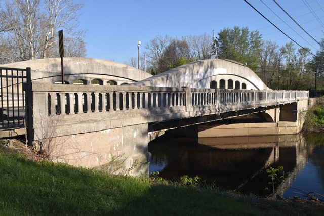
This beautiful and extremely important historic bridge is one of the few rehabilitated examples of this beautiful, unique, and nationally significant structure type that is indigenous to Michigan. Because the bridge has been preserved, the bridge remains in good condition today. The rehabilitation was carried out in good taste and as such the historic significance has not been diminished. This particular example is also one of only two surviving concrete camelback bridges in Michigan to include a cantilevered sidewalk and is the only one with a sidewalk not currently threatened with demolition. The concrete camelback bridges tended to be built in rural locations, which is why few have a sidewalk. Although all of Michigan's surviving camelback bridges should be considered to have a high level of historic and technological significance, this example has added rarity because of its sidewalk, and also stands out as a rare 90 foot span example. It is also noteworthy for its 45 degree skew.

This bridge serves one-way northbound traffic with a 1950s era steel stringer bridge next door carrying the southbound direction of traffic. While not particularly significant from a historical standpoint, the southbound bridge is an attractive companion bridge on account of its retaining Michigan's signature "Type R4" railings. While this "one-way couplet" of bridges was likely created in the 1950s out of a sense of economy rather that historic preservation, these two bridges do clearly demonstrate a technique that can be applied to historic bridges found to be too narrow for the traffic they serve, where a new bridge is built to carry one direction of traffic.
The Okemos Road camelback bridge appears to have been recognized by the local community as the historic landmark it is. A sign welcoming northbound vehicles to downtown Okemos includes a graphic with the bridge at the center of the design. Also, in November 2010, Meridian Township Downtown Development Authority was investigating nominating the bridge for a formal listing in the National Register of Historic Places. While this bridge is already considered "officially historic" by the historic bridge inventory, a formal listing often carries greater weight in the eyes of newspapers and the general public, who may not realize that an eligible finding in a state historic bridge inventory is equivalent to a formal listing in the National Register in terms of available preservation funding and any federal protections such as Section 106.
Moving forward it will be important to ensure that the protective coat of sealant that has been placed on the bridge is maintained to ensure that this bridge remains in good condition. Aesthetically, it would be worth considering the removal of graffiti on the bridge followed by an application of an anti-graffiti coating.

Above: Bridge during a flood in 1975.
Michigan's Concrete Camelback Bridges
All of Michigan's surviving curved chord through girders should be considered historically and technologically significant. The bridges are historically significant because they represent a unique and innovative design developed by the Michigan State Highway Department in its earlier years of bridge construction.
The bridges should be considered technologically significant as well. By incorporating a curve into the design, Michigan State Highway Department not only increased the efficiency of the design, they also greatly increased the aesthetic value of the bridges. The graceful curves of this bridge type, complemented by architectural details such as inset rectangles and pierced openings, make them among the most aesthetically pleasing of bridge types ever encountered. Straight chord through girder bridges are generally considered among the more plain and less visually appealing types of historic bridges. The aesthetic qualities of the curved girder bridge, those qualities being an integral and functional part of the bridge and not a decorative facade, should be considered to be a technologically significant feat: an extremely effective union of function and form.
Also, the 90 foot plan concrete camelbacks, including the Okemos Road Bridge are all noteworthy on a national level because they are among the longest spans seen in concrete through girders throughout the country. They represented the maximum potential of the bridge type, which had a short life because it was limited as a practical structure type in terms of span length and deck width. Most concrete through girders (including the small number of curved chord examples outside Michigan) throughout the country appear to have been limited to no more than 60 feet. With their 90 foot spans, Michigan's 90 foot plan concrete camelbacks push beyond this number considerably.
Statewide, very few examples of this bridge type have been preserved or have evidence of a preservation commitment. Further, the number of examples of this bridge type have been dropping rapidly over the years. Considering that in recent years, Michigan has begun to emerge as a leader in truss bridge preservation, it is reasonable to consider concrete camelback bridges to be the most threatened type of historic bridge in Michigan.
The bridge type has become rare through attrition in Michigan, and the rarity of the bridges today only adds to the significance of those remaining examples.
This bridge is tagged with the following special condition(s): Unorganized Photos
![]()
![]()
![]()

![]()
![]()
![]()

![]()
![]()
This historic bridge has been demolished. This map is shown for reference purposes only.
Coordinates (Latitude, Longitude):
Search For Additional Bridge Listings:
Bridgehunter.com: View listed bridges within 0.5 miles (0.8 kilometers) of this bridge.
Bridgehunter.com: View listed bridges within 10 miles (16 kilometers) of this bridge.
Additional Maps:
Google Streetview (If Available)
GeoHack (Additional Links and Coordinates)
Apple Maps (Via DuckDuckGo Search)
Apple Maps (Apple devices only)
Android: Open Location In Your Map or GPS App
Flickr Gallery (Find Nearby Photos)
Wikimedia Commons (Find Nearby Photos)
Directions Via Sygic For Android
Directions Via Sygic For iOS and Android Dolphin Browser
USGS National Map (United States Only)
Historical USGS Topo Maps (United States Only)
Historic Aerials (United States Only)
CalTopo Maps (United States Only)

© Copyright 2003-2024, HistoricBridges.org. All Rights Reserved. Disclaimer: HistoricBridges.org is a volunteer group of private citizens. HistoricBridges.org is NOT a government agency, does not represent or work with any governmental agencies, nor is it in any way associated with any government agency or any non-profit organization. While we strive for accuracy in our factual content, HistoricBridges.org offers no guarantee of accuracy. Information is provided "as is" without warranty of any kind, either expressed or implied. Information could include technical inaccuracies or errors of omission. Opinions and commentary are the opinions of the respective HistoricBridges.org member who made them and do not necessarily represent the views of anyone else, including any outside photographers whose images may appear on the page in which the commentary appears. HistoricBridges.org does not bear any responsibility for any consequences resulting from the use of this or any other HistoricBridges.org information. Owners and users of bridges have the responsibility of correctly following all applicable laws, rules, and regulations, regardless of any HistoricBridges.org information.
![]()