

View Information About HSR Ratings
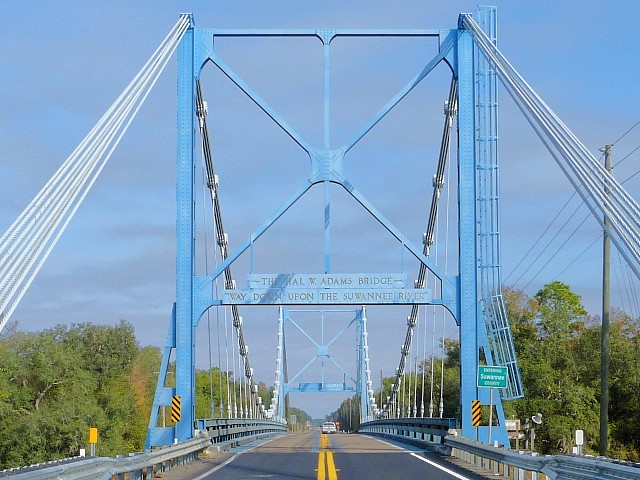
This bridge is the only suspension bridge in Florida, and for that reason it is significant on a state level. The bridge is an icon for the area, and a visually pleasing crossing of the river. As suspension bridges go, usually being reserved for the longest of spans, this is a rare small-scale suspension bridge with a span of only 420 feet. The bridge has riveted steel towers and riveted Warren pony truss stiffening. Uncommon details include the main cable which is composed of eight separate and bare wire cables, rather than a single cable unit with wrapping as is more common. The suspenders are, depending on the panel point, either rod for longer suspenders and bar for shorter suspenders. The anchorages are of simple design with concrete holding eyebars in place which attach to the main cable. The eyebars are not enclosed as in many suspension bridges, and as such the bridge is an uncommon opportunity for visitors to actually see the anchorage's eyebars. The bridge features a series of concrete t-beam approach spans at the northern end only.
![]()
![]()
![]()
Coordinates (Latitude, Longitude):
Search For Additional Bridge Listings:
Bridgehunter.com: View listed bridges within 0.5 miles (0.8 kilometers) of this bridge.
Bridgehunter.com: View listed bridges within 10 miles (16 kilometers) of this bridge.
Additional Maps:
Google Streetview (If Available)
GeoHack (Additional Links and Coordinates)
Apple Maps (Via DuckDuckGo Search)
Apple Maps (Apple devices only)
Android: Open Location In Your Map or GPS App
Flickr Gallery (Find Nearby Photos)
Wikimedia Commons (Find Nearby Photos)
Directions Via Sygic For Android
Directions Via Sygic For iOS and Android Dolphin Browser
USGS National Map (United States Only)
Historical USGS Topo Maps (United States Only)
Historic Aerials (United States Only)
CalTopo Maps (United States Only)

© Copyright 2003-2024, HistoricBridges.org. All Rights Reserved. Disclaimer: HistoricBridges.org is a volunteer group of private citizens. HistoricBridges.org is NOT a government agency, does not represent or work with any governmental agencies, nor is it in any way associated with any government agency or any non-profit organization. While we strive for accuracy in our factual content, HistoricBridges.org offers no guarantee of accuracy. Information is provided "as is" without warranty of any kind, either expressed or implied. Information could include technical inaccuracies or errors of omission. Opinions and commentary are the opinions of the respective HistoricBridges.org member who made them and do not necessarily represent the views of anyone else, including any outside photographers whose images may appear on the page in which the commentary appears. HistoricBridges.org does not bear any responsibility for any consequences resulting from the use of this or any other HistoricBridges.org information. Owners and users of bridges have the responsibility of correctly following all applicable laws, rules, and regulations, regardless of any HistoricBridges.org information.
![]()