

View Information About HSR Ratings
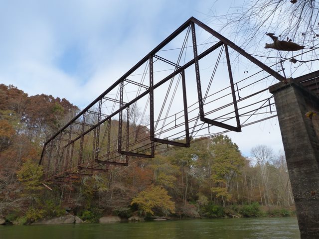
The span length given for this bridge is a rough estimate. Whatever the exact span length is, one thing is clear: this is a very long-span example of a pin-connected Pratt through truss. Typically spans of this length would be something more complicated that a regular Pratt, such as a Whipple or Parker truss. This bridge crosses at a fairly high height over the water, and at the eastern end of the bridge a series of steel stringer approach spans brought the bridge roadway back to ground level.
This bridge was reportedly abandoned in the 1950s. Nothing has been done with the bridge since then. The deck is long-gone, although deck stringers remain for the approach spans. Some of the approach spans are in imminent danger of collapse, and indeed have already partially collapsed with visible sagging. The reason for this is obvious. The steel bent closest to the main span that supports the approach spans has had the concrete foundations they rest on washed away. One of the columns was during the site visible observed to be completely washed out and essentially hanging off the bridge, and others were partially washed out with the foundation tipping over.
For a bridge with obvious historic significance due to its pin-connected design and span length, the neglect is unacceptable. The bridge is actually located in a National Recreation Area, which is managed by the National Park Service. The National Park Service needs to step up and restore this bridge for pedestrian use which would make it an attraction for the area.
![]()
![]()
![]()
Coordinates (Latitude, Longitude):
Search For Additional Bridge Listings:
Bridgehunter.com: View listed bridges within 0.5 miles (0.8 kilometers) of this bridge.
Bridgehunter.com: View listed bridges within 10 miles (16 kilometers) of this bridge.
Additional Maps:
Google Streetview (If Available)
GeoHack (Additional Links and Coordinates)
Apple Maps (Via DuckDuckGo Search)
Apple Maps (Apple devices only)
Android: Open Location In Your Map or GPS App
Flickr Gallery (Find Nearby Photos)
Wikimedia Commons (Find Nearby Photos)
Directions Via Sygic For Android
Directions Via Sygic For iOS and Android Dolphin Browser
USGS National Map (United States Only)
Historical USGS Topo Maps (United States Only)
Historic Aerials (United States Only)
CalTopo Maps (United States Only)

© Copyright 2003-2024, HistoricBridges.org. All Rights Reserved. Disclaimer: HistoricBridges.org is a volunteer group of private citizens. HistoricBridges.org is NOT a government agency, does not represent or work with any governmental agencies, nor is it in any way associated with any government agency or any non-profit organization. While we strive for accuracy in our factual content, HistoricBridges.org offers no guarantee of accuracy. Information is provided "as is" without warranty of any kind, either expressed or implied. Information could include technical inaccuracies or errors of omission. Opinions and commentary are the opinions of the respective HistoricBridges.org member who made them and do not necessarily represent the views of anyone else, including any outside photographers whose images may appear on the page in which the commentary appears. HistoricBridges.org does not bear any responsibility for any consequences resulting from the use of this or any other HistoricBridges.org information. Owners and users of bridges have the responsibility of correctly following all applicable laws, rules, and regulations, regardless of any HistoricBridges.org information.
![]()