

View Information About HSR Ratings

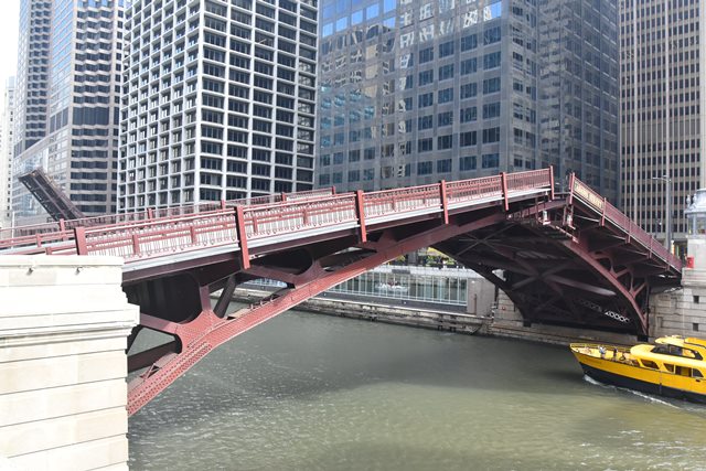
A number of Chicago bridges have most of the trusses below the deck yet part of those trusses remain above the deck as in the State Street Bridge meaning the bridge has some characteristics of a deck truss as well as a pony truss, and were known as railing height trusses. The Adams Street Bridge is however one of the bridges in which the trusses are completely below the deck, making it a true deck truss. This configuration allows the trusses to be more visible to people rather than partially obscured by the deck of the bridge.
Because this bridge was built in a congested area with additional obstacles such as a railroad along the west side of the river the construction details for the trunnion and counterweight pit are not identical at each end, since engineers had to work around unique constraints at each end of the bridge. The 1926 Annual Report of the Public Works indicated that contractors also had to work around two buildings (described as the Farwell building and Ryerson building) that sat directly next to the abutments for the east end of the bridge. Some of the supports for the Ryerson buildings were modified to accommodate the bridge, while the Farwell building received a new foundation.
The bridge replaced a center pier swing bridge at this location.

The clear span of the bridge is 173 Feet with the trunnion-to-trunnion length being 199 feet. The bridge is 64 feet wide. Navigational vertical clearance is 15.74 Feet.
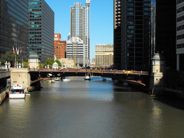
In 1955 Adams Street was converted into a one way road, which made the street the westbound alignment for US-66. As such, this bridge is today a part of Historic Route 66.
In 2012, the sidewalk decks were replaced. At the time, the decks were reinforced concrete. The new sidewalk deck is a lightweight fiberglass material that has been employed on other Chicago bridges in recent years. The curb railings, which did not appear to be original and were as tall as the original sidewalk railings, were replaced. The new curb guardrails are a low profile two-tube guardrail.

A 1949 photo of the bridge tender house control room interior that included labels is shown above. Click the image to view an enlarged image where the labels are legible.
August 26, 2012 marked the 85th anniversary for this bridge. Click here to view a press release article about the 85th Anniversary from Chicago Loop Bridges.
Long ago, it may have been more obvious, but it is hard to tell today that immediately west of the bascule bridge is an approach viaduct that carries Adams Street over the many railroad tracks at Union Station, specifically, the tracks at the north side of the station. As of 2013, apparently a project is being planned to rehabilitate and replace portions of this approach viaduct. These changes are not planned to alter the historic significance of the bascule bridge however.

The first documented bridge at Adams Street was built in 1869 as a hand-turned iron/wood combination bridge by Fox and Howard. The bridge was 160 feet long and 31 feet wide. It was destroyed by the Great Fire of 1871.

Above: This photo shows the second documented Adams Street Bridge. It was built in 1872 by the Keystone Bridge Company. The hand-turned iron swing bridge was 160 feet long and 32 feet wide.


Above: These photos include views of the third documented Adams Street Bridge, which preceded the existing bascule bridge. This bridge was built in 1889 and was a steel swing bridge built by the King Bridge Company of Cleveland, Ohio. The bridge was 259 feet long and 59 feet wide.
|
Main Plaque WM HALE THOMPSONMAYOR
CHICAGO PLAN COMMISSION BENNETT PARSONS & FROST CONSULTING ARCHITECTS CHICAGO CHAPER OF AMERICAN INSTITUTE OF ARCHITECTS ILLINOIS SOCIETY OF ARCHITECTS CHICAGO ART COMMISSON
|
![]()


Chicago and Cook County are home to one of the largest collections of historic bridges in the country, and no other city in the world has more movable bridges. HistoricBridges.org is proud to offer the most extensive coverage of historic Chicago bridges on the Internet.
General Chicago / Cook County Bridge Resources
Chicago's Bridges - By Nathan Holth, author of HistoricBridges.org, this book provides a discussion of the history of Chicago's movable bridges, and includes a virtual tour discussing all movable bridges remaining in Chicago today. Despite this broad coverage, the book is presented in a compact format that is easy to take with you and carry around for reference on a visit to Chicago. The book includes dozens of full color photos. Only $9.95 U.S! ($11.95 Canadian). Order Now Direct From The Publisher! or order on Amazon.
Chicago River Bridges - By Patrick T. McBriarty, this is a great companion to Holth's book shown above. This much larger book offers an extremely in-depth exploration of Chicago's movable highway bridges, including many crossings that have not existed for many years. Order Now Direct From The Publisher! or order on Amazon.
View Historic American Engineering Record (HAER) Overview of Chicago Bascule Bridges (HAER Data Pages, PDF)
Chicago Loop Bridges - Chicago Loop Bridges is another website on the Internet that is a great companion to the HistoricBridges.org coverage of the 18 movable bridges within the Chicago Loop. This website includes additional information such as connections to popular culture, overview discussions and essays about Chicago's movable bridges, additional videos, and current news and events relating to the bridges.
Additional Online Articles and Resources - This page is a large gathering of interesting articles and resources that HistoricBridges.org has uncovered during research, but which were not specific to a particular bridge listing.
This bridge is tagged with the following special condition(s): Unorganized Photos
![]()
![]()
![]()
![]()
![]()

![]()

![]()
Coordinates (Latitude, Longitude):
Search For Additional Bridge Listings:
Bridgehunter.com: View listed bridges within 0.5 miles (0.8 kilometers) of this bridge.
Bridgehunter.com: View listed bridges within 10 miles (16 kilometers) of this bridge.
Additional Maps:
Google Streetview (If Available)
GeoHack (Additional Links and Coordinates)
Apple Maps (Via DuckDuckGo Search)
Apple Maps (Apple devices only)
Android: Open Location In Your Map or GPS App
Flickr Gallery (Find Nearby Photos)
Wikimedia Commons (Find Nearby Photos)
Directions Via Sygic For Android
Directions Via Sygic For iOS and Android Dolphin Browser
USGS National Map (United States Only)
Historical USGS Topo Maps (United States Only)
Historic Aerials (United States Only)
CalTopo Maps (United States Only)

© Copyright 2003-2024, HistoricBridges.org. All Rights Reserved. Disclaimer: HistoricBridges.org is a volunteer group of private citizens. HistoricBridges.org is NOT a government agency, does not represent or work with any governmental agencies, nor is it in any way associated with any government agency or any non-profit organization. While we strive for accuracy in our factual content, HistoricBridges.org offers no guarantee of accuracy. Information is provided "as is" without warranty of any kind, either expressed or implied. Information could include technical inaccuracies or errors of omission. Opinions and commentary are the opinions of the respective HistoricBridges.org member who made them and do not necessarily represent the views of anyone else, including any outside photographers whose images may appear on the page in which the commentary appears. HistoricBridges.org does not bear any responsibility for any consequences resulting from the use of this or any other HistoricBridges.org information. Owners and users of bridges have the responsibility of correctly following all applicable laws, rules, and regulations, regardless of any HistoricBridges.org information.
![]()