

View Information About HSR Ratings
About Lakeshore Drive and Lincoln Park

Lakeshore Drive is a major non-interstate limited access highway which follows the Lake Michigan Shoreline in Chicago. The highway is historically significant as an early example of a limited access highway. As evidence of how early an example it is, portions of the highway are also historically significant for being constructed under a Depression-era Works Progress Administration project conducted between 1937 and 1941. The highway passes through Lincoln Park, which is a large park that runs along Lake Michigan for a significant distance in the area of Chicago which is itself known as the Lincoln Park neighborhood. Lincoln Park is considered historically significant and the park is home to a large Historic District included on the National Register of Historic Places. The section of Lakeshore Drive which passes through Lincoln Park is a section that was constructed as part of the aforementioned 1937-1941 WPA project. The project included a number of bridges which incorporate architectural/aesthetic detailing and design, most in an architectural style based on the ideas of Art Deco. As such, many of those bridges which survive today are considered contributing structures to the Lincoln Park Historic District. These bridges should also be considered historically significant as surviving infrastructure from an early limited access highway as well.
About This Bridge
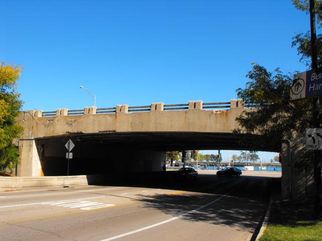
The Belmont Avenue Overpass stands out among the surviving Lakeshore Drive Bridges as unique. The curved t-beams beams are dissimilar in appearance and design to many of the bridges on Lakeshore Drive. Further, the aesthetic detailing, most notably the railing, is quite different as well. The railings on the Belmont Avenue Overpass contain short, wide concrete posts that are linked together by two concrete poles. Overall, this bridge appears to retain good historic integrity.
To the right, a historical photo shows an aerial view of the Belmont Avenue Overpass.
Information and Findings From Lincoln Park National Register Historic District NominationDiscussion of Bridge South of Addison St., Lake Shore Dr. makes an incline above grade to the next structure that allows automobiles to pass underneath, the Belmont Dr. Bridge. This reinforced concrete bridge is Art Deco in style, although it is very simple and stark. The bridge has a flattened arch opening and its rail is a solid concrete face. The abutment wall has a gentle concave curve that meets with short straight sections of approach wall. Along the span of the opening, the rail is not completely solid. Rather, it has crenelated concrete forms that have horizontal double bands. This detail is repeated at the approach wall. The Belmont Dr. bridge was recently repaired and patched by the City of Chicago. Discussion of Lakeshore Drive The widening and improving of Lake Shore Dr. into a limited access highway between 1937 and 1941 was probably the most ambitious of all of the WPA projects in Lincoln Park. The intent was to create a continuous route for heavy traffic that would segregate" persons passing through the park as a matter of convenience and those who come to it to enjoy its many attractions and recreation facilities" (CPO Annual Report 1937,106). This included a grade separation system that resulted in stylized Art Deco concrete bridge overpasses at the La Salle Dr. extension, Fullerton Pkwy., Diversey Pkwy., Belmont Dr., Lawrence Dr. and Wilson Dr., most of which had attractive engaged lighting fixtures. There are also a number of underpass bridges that allow pedestrian access beneath Lake Shore Dr. Some are utilitarian concrete structures that are essentially unadorned. An underpass that allows pedestrians to cross beneath Lake Shore Dr. at Barry Ave. is a stylized Deco structure that was likely designed by Buchsbaum. It is documented that four simple lannon stone pedestrian underpass bridges in the Montrose Ave. extension east of Lake Shore Dr. were designed by Buchsbaum. There were also some small sections of Art Deco retaining walls on Lake Shore Dr. that can probably be attributed to Buchsbaum. There is a remaining section of wall at the Lake Shore Dr. curve east of the Oak Street triangle. Based on "modern principles of highway design" the Lake Shore Dr. improvements allowed for a straight two-way route which totaled eight lanes at its widest point between the La Salle Dr. extension and Belmont Dr. (CPO Seventh Annual Report 1941,157). This southern area of the drive included a flexible rush-hour traffic system of hydraulic lane separators. This mechanical system of concrete "movable fins," would raise to configure various lanes of traffic at different times of day (ibid.). The hydraulic separators did not continue north of Belmont Dr. to Foster Dr. This area had a width of only six lanes, allowing for a center island landscape that followed the earlier stylistic treatment of the boulevard system. Lake Shore Drive's grade separation system continued north from the La Salle Dr. extension. The section between Belmont Dr. and Foster Dr. had four cloverleaf ramps linking the drive with the park and city streets. Today, Lake Shore Dr. is a major arterial spine that extends through the entire seven mile length of Lincoln Park. The drive's current appearance primarily resulted from a WPA funded project between 1937 and 1941. Lake Shore Drive was developed as a limited access highway that would provide a continuous traffic route through the park. Re-grading was done and a number of bridges were constructed so that many portions of the new drive were elevated above the roads and paths that allowed access throughout Lincoln Park. |
![]()


Chicago and Cook County are home to one of the largest collections of historic bridges in the country, and no other city in the world has more movable bridges. HistoricBridges.org is proud to offer the most extensive coverage of historic Chicago bridges on the Internet.
General Chicago / Cook County Bridge Resources
Chicago's Bridges - By Nathan Holth, author of HistoricBridges.org, this book provides a discussion of the history of Chicago's movable bridges, and includes a virtual tour discussing all movable bridges remaining in Chicago today. Despite this broad coverage, the book is presented in a compact format that is easy to take with you and carry around for reference on a visit to Chicago. The book includes dozens of full color photos. Only $9.95 U.S! ($11.95 Canadian). Order Now Direct From The Publisher! or order on Amazon.
Chicago River Bridges - By Patrick T. McBriarty, this is a great companion to Holth's book shown above. This much larger book offers an extremely in-depth exploration of Chicago's movable highway bridges, including many crossings that have not existed for many years. Order Now Direct From The Publisher! or order on Amazon.
View Historic American Engineering Record (HAER) Overview of Chicago Bascule Bridges (HAER Data Pages, PDF)
Chicago Loop Bridges - Chicago Loop Bridges is another website on the Internet that is a great companion to the HistoricBridges.org coverage of the 18 movable bridges within the Chicago Loop. This website includes additional information such as connections to popular culture, overview discussions and essays about Chicago's movable bridges, additional videos, and current news and events relating to the bridges.
Additional Online Articles and Resources - This page is a large gathering of interesting articles and resources that HistoricBridges.org has uncovered during research, but which were not specific to a particular bridge listing.
![]()
![]()
![]()
Coordinates (Latitude, Longitude):
Search For Additional Bridge Listings:
Bridgehunter.com: View listed bridges within 0.5 miles (0.8 kilometers) of this bridge.
Bridgehunter.com: View listed bridges within 10 miles (16 kilometers) of this bridge.
Additional Maps:
Google Streetview (If Available)
GeoHack (Additional Links and Coordinates)
Apple Maps (Via DuckDuckGo Search)
Apple Maps (Apple devices only)
Android: Open Location In Your Map or GPS App
Flickr Gallery (Find Nearby Photos)
Wikimedia Commons (Find Nearby Photos)
Directions Via Sygic For Android
Directions Via Sygic For iOS and Android Dolphin Browser
USGS National Map (United States Only)
Historical USGS Topo Maps (United States Only)
Historic Aerials (United States Only)
CalTopo Maps (United States Only)

© Copyright 2003-2024, HistoricBridges.org. All Rights Reserved. Disclaimer: HistoricBridges.org is a volunteer group of private citizens. HistoricBridges.org is NOT a government agency, does not represent or work with any governmental agencies, nor is it in any way associated with any government agency or any non-profit organization. While we strive for accuracy in our factual content, HistoricBridges.org offers no guarantee of accuracy. Information is provided "as is" without warranty of any kind, either expressed or implied. Information could include technical inaccuracies or errors of omission. Opinions and commentary are the opinions of the respective HistoricBridges.org member who made them and do not necessarily represent the views of anyone else, including any outside photographers whose images may appear on the page in which the commentary appears. HistoricBridges.org does not bear any responsibility for any consequences resulting from the use of this or any other HistoricBridges.org information. Owners and users of bridges have the responsibility of correctly following all applicable laws, rules, and regulations, regardless of any HistoricBridges.org information.
![]()