HistoricBridges.org Menu: HistoricBridges.org Menu:


We Recommend:
Bach Steel - Experts at historic truss bridge restoration.

HistoricBridges.org: Bridge Browser

I-270 Chain of Rocks Canal Bridge

I-270 Chain of Rocks Canal Bridge

Primary Photographer(s): Nathan Holth

Bridge Documented: November 3, 2013

View Photos
and Videos
View Maps
and Links

Facility Carried / Feature Intersected
I-270 Over Chain of Rocks Canal
Location
Granite City: Madison County, Illinois: United States
Structure Type
Metal Cantilever 16 Panel Bolt-Connected Warren Through Truss, Fixed and Approach Spans: Metal Continuous Stringer (Multi-Beam),
Construction Date and Builder / Engineer
1963 By Builder/Contractor: American Bridge Company of New York, New York and Engineer/Design: Sverdrup and Parcel of St. Louis, Missouri
Rehabilitation Date
Not Available or Not Applicable
Main Span Length
480.0 Feet (146.3 Meters)
Structure Length
1,990.3 Feet (606.6 Meters)
Roadway Width
30 Feet (9.14 Meters)
Spans
3 Main Span(s) and 9 Approach Span(s)
Inventory Number
60003614266

Historic Significance Rating (HSR)
View Information About HSR Ratings

Bridge Documentation

This bridge no longer exists!

View Archived National Bridge Inventory Report - Has Additional Details and Evaluation

Download Original And Rehab Plans For This Historic Bridge

This historic bridge was demolished and replaced January-February 2015 By IDOT!

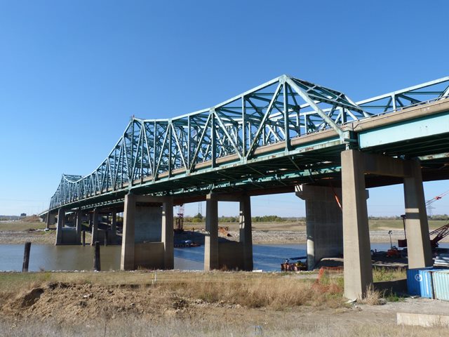
Although this bridge was a late example of cantilever truss bridge technology, it was an attractive structure that made an otherwise boring expressway drive something noteworthy. Indeed the ugliness of the steel stringer bridge that has replaced this truss bridge makes a great argument for preserving truss bridges for the sake of beauty alone. The bridge was noteworthy as a good representation of truss bridge construction in the 1960s. The use of bolts for field connections instead of rivets is indicative of the decline in use of rivets during this period, and the lack of v-lacing and lattice in the bridge's built-up beams is also indicative of a transition away from more complex forms of built-up beams during this period.


Divider

Photo Galleries and Videos: I-270 Chain of Rocks Canal Bridge


View Photo Gallery

Bridge Photo-Documentation

Original / Full Size Photos
A collection of overview and detail photos. This gallery offers photos in the highest available resolution and file size in a touch-friendly popup viewer.
Alternatively, Browse Without Using Viewer

Divider

View Photo Gallery

Bridge Photo-Documentation

Mobile Optimized Photos
A collection of overview and detail photos. This gallery features data-friendly, fast-loading photos in a touch-friendly popup viewer.
Alternatively, Browse Without Using Viewer

Divider

View Video

CarCam: Eastbound Crossing

Full Motion Video
Note: The downloadable high quality version of this video (available on the video page) is well worth the download since it offers excellent 1080 HD detail and is vastly more impressive than the compressed streaming video. Streaming video of the bridge. Also includes a higher quality downloadable video for greater clarity or offline viewing.

Divider

Maps and Links: I-270 Chain of Rocks Canal Bridge

This historic bridge has been demolished. This map is shown for reference purposes only.

Coordinates (Latitude, Longitude):

Search For Additional Bridge Listings:

Bridgehunter.com: View listed bridges within 0.5 miles (0.8 kilometers) of this bridge.

Bridgehunter.com: View listed bridges within 10 miles (16 kilometers) of this bridge.

HistoricBridges.org Bridge Browser: View listed bridges within 0.5 miles (0.8 kilometers) of this bridge.

HistoricBridges.org Bridge Browser: View listed bridges within 10 miles (16 kilometers) of this bridge.

2021 National Bridge Inventory: View listed bridges within 0.5 miles (0.8 kilometers) of this bridge.

Additional Maps:

Google Maps

Google Streetview (If Available)

Bing Maps

OpenStreetMap

GeoHack (Additional Links and Coordinates)

Apple Maps (Via DuckDuckGo Search)

Apple Maps (Apple devices only)

MapQuest

HERE We Go Maps

ACME Mapper

Waze Map

Android: Open Location In Your Map or GPS App

Flickr Gallery (Find Nearby Photos)

Wikimedia Commons (Find Nearby Photos)

Directions Via Sygic For Android

Directions Via Sygic For iOS and Android Dolphin Browser

USGS National Map (United States Only)

Historical USGS Topo Maps (United States Only)

Historic Aerials (United States Only)

CalTopo Maps (United States Only)


Divider
 
Home Top

Divider

About - Contact

© Copyright 2003-2024, HistoricBridges.org. All Rights Reserved. Disclaimer: HistoricBridges.org is a volunteer group of private citizens. HistoricBridges.org is NOT a government agency, does not represent or work with any governmental agencies, nor is it in any way associated with any government agency or any non-profit organization. While we strive for accuracy in our factual content, HistoricBridges.org offers no guarantee of accuracy. Information is provided "as is" without warranty of any kind, either expressed or implied. Information could include technical inaccuracies or errors of omission. Opinions and commentary are the opinions of the respective HistoricBridges.org member who made them and do not necessarily represent the views of anyone else, including any outside photographers whose images may appear on the page in which the commentary appears. HistoricBridges.org does not bear any responsibility for any consequences resulting from the use of this or any other HistoricBridges.org information. Owners and users of bridges have the responsibility of correctly following all applicable laws, rules, and regulations, regardless of any HistoricBridges.org information.

Admin Login

Divider