

View Information About HSR Ratings
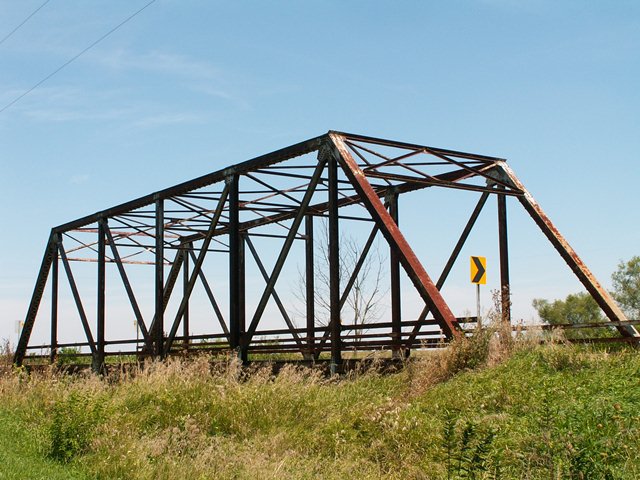
This Pratt through truss is a bridge showing both rivets and bolts. The connections are bolted, but all built-up beams are riveted. The 1955 construction date given for the bridge seemed like it matched up with the rivet/bolt combination design of this Iroquois County bridge, however HistoricBridges.org located a Cambria steel stamp on the bridge. Bethlehem Steel acquired all the Cambria steel property in 1923, so the name was likely faded out rather soon after that date, and certainly wouldn't be around in 1955. This bridge is suspiciously similar to the 1900 Bridge which had a 1916 construction date listed. The only real difference between the two bridges is the connections on the 1900 bridge are riveted. A guess for the history of the 1850 bridge is that the bridge might have been built around 1915-1920, and in 1955 received heavy renovations which included replacing riveted connections with bolts.
This bridge features a portal bracing that uses the exact same layout as its sway bracing. There are six panels to the structure. There are channel railings on this bridge, which are very similar to those seen on Iroquois County's older pin-connected truss bridges, which make one wonder if the railings, which looked original on those older Iroquois County bridges, might in fact be clever replacement railings that are really not original to any of these bridges. The reason for this suspicion is because it would be odd that all of Iroquois County's bridges have these channel railings regardless of construction date.
![]()
![]()
![]()
This historic bridge has been demolished. This map is shown for reference purposes only.
Coordinates (Latitude, Longitude):
Search For Additional Bridge Listings:
Bridgehunter.com: View listed bridges within 0.5 miles (0.8 kilometers) of this bridge.
Bridgehunter.com: View listed bridges within 10 miles (16 kilometers) of this bridge.
Additional Maps:
Google Streetview (If Available)
GeoHack (Additional Links and Coordinates)
Apple Maps (Via DuckDuckGo Search)
Apple Maps (Apple devices only)
Android: Open Location In Your Map or GPS App
Flickr Gallery (Find Nearby Photos)
Wikimedia Commons (Find Nearby Photos)
Directions Via Sygic For Android
Directions Via Sygic For iOS and Android Dolphin Browser
USGS National Map (United States Only)
Historical USGS Topo Maps (United States Only)
Historic Aerials (United States Only)
CalTopo Maps (United States Only)

© Copyright 2003-2024, HistoricBridges.org. All Rights Reserved. Disclaimer: HistoricBridges.org is a volunteer group of private citizens. HistoricBridges.org is NOT a government agency, does not represent or work with any governmental agencies, nor is it in any way associated with any government agency or any non-profit organization. While we strive for accuracy in our factual content, HistoricBridges.org offers no guarantee of accuracy. Information is provided "as is" without warranty of any kind, either expressed or implied. Information could include technical inaccuracies or errors of omission. Opinions and commentary are the opinions of the respective HistoricBridges.org member who made them and do not necessarily represent the views of anyone else, including any outside photographers whose images may appear on the page in which the commentary appears. HistoricBridges.org does not bear any responsibility for any consequences resulting from the use of this or any other HistoricBridges.org information. Owners and users of bridges have the responsibility of correctly following all applicable laws, rules, and regulations, regardless of any HistoricBridges.org information.
![]()