

View Information About HSR Ratings
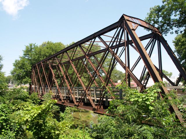
This bridge is an excellent example of a truss bridge with a lattice type truss configuration. Although the deck has been converted for pedestrian use, the truss itself is largely unaltered and in good condition.
Tom Winkle did some excellent research and investigation into this bridge and was able to learn about the railroad this bridge originally served. His research also suggests that this bridge dates to before 1909. His comments are below.
I stopped into the Grundy County Historical Museum to see if they might
know anything about the bridge. (The museum is just west of the bridge at the
end of Illinois Avenue.) The gentleman I talked to first seemed to think it was
a bridge across the canal for the first highway bridge across the Illinois,
which was connected to Calhoun St. I said that it looked too narrow and too tall
to be a road bridge, and that it might have been a single track rail bridge, but
I could not see any evidence of a rail grade to the west of the bridge.
This prompted them to get out some old plat map books that they had. In the 1872
plat book, there was no evidence of anything there at all. However, in the 1909
book, it was there. It was part of the Morris Terminal R.R., which served a
tannery located between the canal and the river, and businesses and warehouses
on Illinois Avenue. The terminal line branched off of the Rock Island east of
Morris, served a box plant at that end of town, crossed the canal, proceeded
west on the south bank and crossed the canal again via the lattice truss bridge
to get to Illinois Avenue. The eastern end bridge is gone. My contact said that
there is evidence of a grade there with old ties scattered all over.
![]()
![]()
![]()
Coordinates (Latitude, Longitude):
Search For Additional Bridge Listings:
Bridgehunter.com: View listed bridges within 0.5 miles (0.8 kilometers) of this bridge.
Bridgehunter.com: View listed bridges within 10 miles (16 kilometers) of this bridge.
Additional Maps:
Google Streetview (If Available)
GeoHack (Additional Links and Coordinates)
Apple Maps (Via DuckDuckGo Search)
Apple Maps (Apple devices only)
Android: Open Location In Your Map or GPS App
Flickr Gallery (Find Nearby Photos)
Wikimedia Commons (Find Nearby Photos)
Directions Via Sygic For Android
Directions Via Sygic For iOS and Android Dolphin Browser
USGS National Map (United States Only)
Historical USGS Topo Maps (United States Only)
Historic Aerials (United States Only)
CalTopo Maps (United States Only)

© Copyright 2003-2024, HistoricBridges.org. All Rights Reserved. Disclaimer: HistoricBridges.org is a volunteer group of private citizens. HistoricBridges.org is NOT a government agency, does not represent or work with any governmental agencies, nor is it in any way associated with any government agency or any non-profit organization. While we strive for accuracy in our factual content, HistoricBridges.org offers no guarantee of accuracy. Information is provided "as is" without warranty of any kind, either expressed or implied. Information could include technical inaccuracies or errors of omission. Opinions and commentary are the opinions of the respective HistoricBridges.org member who made them and do not necessarily represent the views of anyone else, including any outside photographers whose images may appear on the page in which the commentary appears. HistoricBridges.org does not bear any responsibility for any consequences resulting from the use of this or any other HistoricBridges.org information. Owners and users of bridges have the responsibility of correctly following all applicable laws, rules, and regulations, regardless of any HistoricBridges.org information.
![]()