

View Information About HSR Ratings
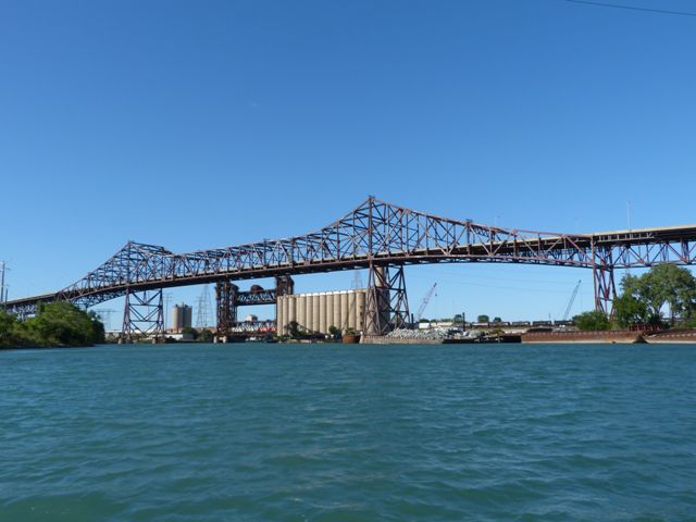
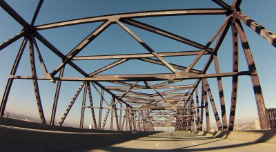
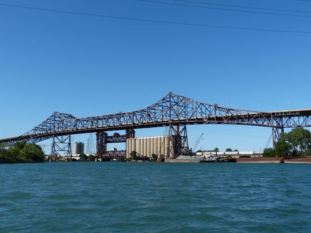
This bridge is an early example of a bridge whose design did not use any of the v-lacing and lattice that was popular in decades past and still occasionally used in the 1950s, instead using rolled beams or built-up beams of more simple appearance. This tends to make this bridge look newer than it is, perhaps more like a bridge from the 1970s. The bridge also has an overall design that makes it appear somewhat more modern because of its slender steel piers and shallow rise of trusses over the roadway.

The bridge and viaduct system including all approaches totals 7.8 miles in length. The listed navigational vertical clearance for the bridge is 125 feet. The bridge's 650 foot main span is flanked by 325 foot spans on each side.
The bridge's toll plaza retains much of its original overall appearance and design, something not frequently seen on toll roads and bridges.
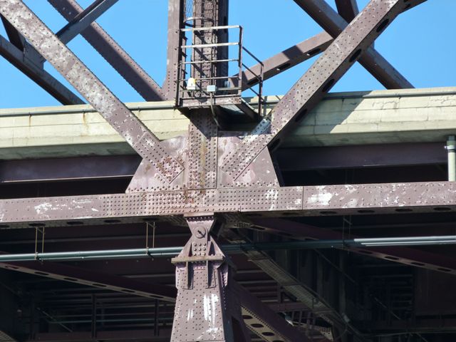
The Mount Vernon Bridge Company, Bethlehem Steel, and U.S. Steel (American Bridge) all played a role in fabricating parts of the bridge and approach system. The designed was JE Greiner Company, which was a firm created by John Edwin Greiner. He worked with the Baltimore and Ohio Railroad until leaving to form his own consulting company around 1908. He opened offices in Baltimore, Maryland as well as Chicago and New York City. John Greiner and his firm were noted for the construction of large and long-span bridges, like the Skyway Bridge. One of J.E. Greiner Company's more contemporary noteworthy achievements was the invention of the single-point urban interchange (SPUI) in Florida in the 1970s. The company remained an independent business until 1996, until the company, then called simply Greiner Engineering, became part of URS Corporation.
The bridge was originally built and owned by the City of Chicago. The bridge and the approaching roadway leading up to it were all legally described as a bridge because the city's laws allowed the city to own toll bridges but not toll roads. In a physical sense much of the approaching roadway is indeed a bridge, with the Chicago Skyway essentially configured as an elevated road. The toll project was never as profitable for them as hoped. In 2006, the publically owned bridge was sold by the City of Chicago and it became foreign-owned private property owned under a 99 year lease by Spanish and Australian interests who formed a company called Skyway Concession Company to own the bridge. This company continues to provide tolled public access to the bridge and roadway in much the same way that the city once did. It is unclear what this ownership change might mean for the preservation of this bridge.
This bridge is extremely difficult to photograph on land, therefore requiring a boat to get a full photo-documentation of the bridge. Thanks to Tom Winkle for providing boat transportation to assist in the photo-documentation of this historic bridge.
The 1954 Chicago Annual Report of the Public Works Department states that the design speed of the Chicago Skyway Toll Bridge including its approaches were designed for speeds of 60 miles per hour. However, the posted speed limit over the bridge today is only 45 miles per hour.


|
Main Plaque CALUMET SKYWAYTOLL BRIDGE CITY OF CHICAGO RICHARD J. DALEY MAYOR BUILT BY DEPARTMENT OF PUBLIC WORKS GEORGE L. DeMENT . . . . COMMISSIONER JOHN G. DUBA . . . ADMINISTRATIVE ENGINEER JOHN C. MELANIPHY . CORPORATION COUNSEL JOHN F. WARD . . . . . PURCHASING AGENT CARL H. CHATTERS . . . . . . COMPTROLLER DeLEUW, CATHER & COMPANY CONSULTING ENGINEERS SECTION ENGINEERS
1955-1958 |

Above: Historical advertisement featuring bridge.


![]()


Chicago and Cook County are home to one of the largest collections of historic bridges in the country, and no other city in the world has more movable bridges. HistoricBridges.org is proud to offer the most extensive coverage of historic Chicago bridges on the Internet.
General Chicago / Cook County Bridge Resources
Chicago's Bridges - By Nathan Holth, author of HistoricBridges.org, this book provides a discussion of the history of Chicago's movable bridges, and includes a virtual tour discussing all movable bridges remaining in Chicago today. Despite this broad coverage, the book is presented in a compact format that is easy to take with you and carry around for reference on a visit to Chicago. The book includes dozens of full color photos. Only $9.95 U.S! ($11.95 Canadian). Order Now Direct From The Publisher! or order on Amazon.
Chicago River Bridges - By Patrick T. McBriarty, this is a great companion to Holth's book shown above. This much larger book offers an extremely in-depth exploration of Chicago's movable highway bridges, including many crossings that have not existed for many years. Order Now Direct From The Publisher! or order on Amazon.
View Historic American Engineering Record (HAER) Overview of Chicago Bascule Bridges (HAER Data Pages, PDF)
Chicago Loop Bridges - Chicago Loop Bridges is another website on the Internet that is a great companion to the HistoricBridges.org coverage of the 18 movable bridges within the Chicago Loop. This website includes additional information such as connections to popular culture, overview discussions and essays about Chicago's movable bridges, additional videos, and current news and events relating to the bridges.
Additional Online Articles and Resources - This page is a large gathering of interesting articles and resources that HistoricBridges.org has uncovered during research, but which were not specific to a particular bridge listing.
![]()
![]()
![]()
![]()
![]()

![]()
Coordinates (Latitude, Longitude):
Search For Additional Bridge Listings:
Bridgehunter.com: View listed bridges within 0.5 miles (0.8 kilometers) of this bridge.
Bridgehunter.com: View listed bridges within 10 miles (16 kilometers) of this bridge.
Additional Maps:
Google Streetview (If Available)
GeoHack (Additional Links and Coordinates)
Apple Maps (Via DuckDuckGo Search)
Apple Maps (Apple devices only)
Android: Open Location In Your Map or GPS App
Flickr Gallery (Find Nearby Photos)
Wikimedia Commons (Find Nearby Photos)
Directions Via Sygic For Android
Directions Via Sygic For iOS and Android Dolphin Browser
USGS National Map (United States Only)
Historical USGS Topo Maps (United States Only)
Historic Aerials (United States Only)
CalTopo Maps (United States Only)

© Copyright 2003-2024, HistoricBridges.org. All Rights Reserved. Disclaimer: HistoricBridges.org is a volunteer group of private citizens. HistoricBridges.org is NOT a government agency, does not represent or work with any governmental agencies, nor is it in any way associated with any government agency or any non-profit organization. While we strive for accuracy in our factual content, HistoricBridges.org offers no guarantee of accuracy. Information is provided "as is" without warranty of any kind, either expressed or implied. Information could include technical inaccuracies or errors of omission. Opinions and commentary are the opinions of the respective HistoricBridges.org member who made them and do not necessarily represent the views of anyone else, including any outside photographers whose images may appear on the page in which the commentary appears. HistoricBridges.org does not bear any responsibility for any consequences resulting from the use of this or any other HistoricBridges.org information. Owners and users of bridges have the responsibility of correctly following all applicable laws, rules, and regulations, regardless of any HistoricBridges.org information.
![]()