

View Information About HSR Ratings
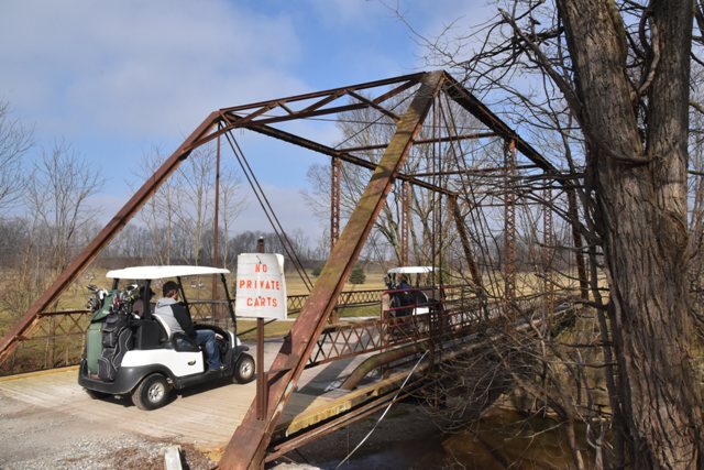
This is a traditionally composed Pratt through truss. It does have uncommon cast iron connectors on the floorbeams for the lateral bracing rods. The bridge is in its original location, but the road it served has been converted to an integral part of a golf course, a nice reuse for the bridge that it handles well. The bridge can still be driven to for viewing from the road leading east of the bridge.
Information and Findings From DHPA Historic Bridge SurveyStatement of Significance When in a joint board meeting in September 1900 the commissioners of Carroll and Clinton counties decided to build a bridge over Middle Fork Creek on the county line, they appointed Charles Huffine, the Clinton County Surveyor, to prepare plans and specifications for the structure, and they announced a letting the following month at the Clinton County courthouse. By bringing in "the lowest and best bid" at $4190, James M. Peirce of Carroll County won the contract for the complete structure. Peirce completed the cut-stone abutments and wingwalls by the end of the year and erected the superstructure soon thereafter. He built the earthen approach to the north on a separate contract with Carroll County in the first half of 1901. The webbing of this pin-connected Pratt through-span is quite light. A pair of die-forged eyebars provide each hip vertical and laced channels the intermediate ones. A pair of die-forged eyebars serve as diagonal sets in the second and fourth panels, and a pair of adjustable and cylindrical rods supply the diagonal and counter set in the most central panel. The I floor-beams are U-bolted to the lower pins. The trusses have been supported with cables running below the floor-beams from abutment to abutment. The bridge carries a 16-ft. asphalt and metal pan deck with 14 feet of vertical roadway clearance. Seated upon cut stone abutments and wingwalls, this single-span, pin-connected Pratt through span extends 86' in five panels. A pair of laced channels provides each set of intermediate verticals, a pair of die-forged eyebars serve as diagonal sets in the second and fourth panels, and a pair of adjustable and cylindrical rods supply the diagonal and counter set in the most central panel. The I floor-beams are U-bolted to the lower pins and have been reinforced with cables run from abutment to abutment. The bridge carries a 16' asphalt and metal pan deck. Adjacent to an old sawmill, Hufford's ford had been an established part of the two-county transportation network since before the 1870's. The builder of Hufford's Ford Bridge, James M. Peirce, won many bridge contracts in Carroll County in the 1890s and later, especially for substructures. He was a particularly prolific builder of cut-stone abutments like those for this structure. The Pratt superstructure was designed to be light, making it easy for the fabricator to get transported to the bridge site for the contractor to assemble. This bridge retains its original members, including latticed guardrails. The structure is of rather standard design. This bridge retains its original members, including latticed guardrails, although the deck has been supported. Other Information References Charles J. Ritzler, Bridge Inspection Report: Carroll County (Delphi, 1974-75). Carroll Co., "Commissioners Record," 20: 323, 370, 394-5, 444. Clinton Co., "Commissioners Record," 25: 194, 210-11. Carroll Co. Citizen-Times, 6, 13 October 1900. Bridge Considered Historic By Survey: Yes |
![]()
![]()
![]()
Approach this bridge from the south and west. The north approach is not open to the public.
Coordinates (Latitude, Longitude):
Search For Additional Bridge Listings:
Bridgehunter.com: View listed bridges within 0.5 miles (0.8 kilometers) of this bridge.
Bridgehunter.com: View listed bridges within 10 miles (16 kilometers) of this bridge.
Additional Maps:
Google Streetview (If Available)
GeoHack (Additional Links and Coordinates)
Apple Maps (Via DuckDuckGo Search)
Apple Maps (Apple devices only)
Android: Open Location In Your Map or GPS App
Flickr Gallery (Find Nearby Photos)
Wikimedia Commons (Find Nearby Photos)
Directions Via Sygic For Android
Directions Via Sygic For iOS and Android Dolphin Browser
USGS National Map (United States Only)
Historical USGS Topo Maps (United States Only)
Historic Aerials (United States Only)
CalTopo Maps (United States Only)

© Copyright 2003-2024, HistoricBridges.org. All Rights Reserved. Disclaimer: HistoricBridges.org is a volunteer group of private citizens. HistoricBridges.org is NOT a government agency, does not represent or work with any governmental agencies, nor is it in any way associated with any government agency or any non-profit organization. While we strive for accuracy in our factual content, HistoricBridges.org offers no guarantee of accuracy. Information is provided "as is" without warranty of any kind, either expressed or implied. Information could include technical inaccuracies or errors of omission. Opinions and commentary are the opinions of the respective HistoricBridges.org member who made them and do not necessarily represent the views of anyone else, including any outside photographers whose images may appear on the page in which the commentary appears. HistoricBridges.org does not bear any responsibility for any consequences resulting from the use of this or any other HistoricBridges.org information. Owners and users of bridges have the responsibility of correctly following all applicable laws, rules, and regulations, regardless of any HistoricBridges.org information.
![]()