

View Information About HSR Ratings
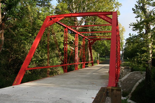
This bridge is a beautiful example of the Massillon Bridge Company's work. The bridge is noted for its attractive and unusual portal bracing, composed of plate with flower-shaped cutouts. The bridge was restored in 2011, with no substantial loss to the bridge excellent historic integrity. The bridge's built-up floor beams remain in place. The abutments for the bridge are stone. The bridge has simple channel railings.
Information and Findings From DHPA Historic Bridge SurveyStatement of Significance A prolific Ohio firm, the Massillon Bridge Company used a fairly conventional design for this quite old Pratt truss span. The truss webbing is fairly light. The span retains its original members, including its nicely-decorated portals and bracing. Architectural Description The Massillon Bridge Company of Massillon, Ohio, erected this single-span, pin-connected Pratt through structure upon cut-stone abutments and wingwalls. The trusses span 81' in six panels. The lower-chord members are composed of a pair of rectangular eyebars, lighter in the outer than in the inner panels. Laced channels of a single size provide the intermediate verticals, and a pair of small rectangular eyebars supply the hip-vertical suspenders. Each panel beyond the outer or endpost ones carries diagonals: they consist of a pair of nearly-square 1.25" eyebars. The two most central panels are each countered with a 1"-square and adjustable bar. U-bolted to the lower pins, girder floor beams carry a concrete deck with a 15'9" roadway. Decorated portals and bracing support the trusses. Other Information The Johnson county commissioners decided in August of 1885 to build a wooden or iron bridge on a stone substructure over Nineveh Creek to make it easier for the Elliotts and Pritchards to get to church, post office, and the other amenities of the villages of Nineveh and Williamsburg. At the September letting, the Board received two bids for the substructure and four for the superstructure. Nearly always finding the lowest bid as best, the commissioners contracted with James H. Pudney at $8.25 per yard for the masonry and with the Massillon Bridge Company at $1,205.40 for the iron superstructure. Pudney finished the stone work by the end of 1885, and Massillon Bridge erected the trusses early in 1886. The pin-connected Pratt through-truss span extends 81-ft. subdivided into six panels. The end-posts and top-chord members consist of a pair of laced channels and cover plate. A pair of rectangular, die-forged eyebars, lighter in the outer than in the inner panels, supply the lower- chord members. A pair of small rectangular eyebars hang as hip-verticals. Laced channels of a single size provide the intermediate ones. The diagonals consist of a pair of nearly-square 1.25-in. eyebars. The two most central panels are each countered with a 1 in. square and adjustable bar. To address sway, the portals carry struts made from a pair of angles and plate--with flower punch-outs for decoration--and reinforced with knee braces of angles and plate. The intermediate struts consist of a pair of small channels riveted to each other. In addition, round rods threaded at their ends for adjustment provide upper and lower lateral bracing. U-bolted to the lower pins, rectangular girder floor-beams support I-beam stringers. The beams and stringers together carry the 16-ft. concrete roadway. A small channel lines each truss as a rail. Bridge Considered Historic By Survey: Yes |
![]()
![]()
![]()
Coordinates (Latitude, Longitude):
Search For Additional Bridge Listings:
Bridgehunter.com: View listed bridges within 0.5 miles (0.8 kilometers) of this bridge.
Bridgehunter.com: View listed bridges within 10 miles (16 kilometers) of this bridge.
Additional Maps:
Google Streetview (If Available)
GeoHack (Additional Links and Coordinates)
Apple Maps (Via DuckDuckGo Search)
Apple Maps (Apple devices only)
Android: Open Location In Your Map or GPS App
Flickr Gallery (Find Nearby Photos)
Wikimedia Commons (Find Nearby Photos)
Directions Via Sygic For Android
Directions Via Sygic For iOS and Android Dolphin Browser
USGS National Map (United States Only)
Historical USGS Topo Maps (United States Only)
Historic Aerials (United States Only)
CalTopo Maps (United States Only)

© Copyright 2003-2024, HistoricBridges.org. All Rights Reserved. Disclaimer: HistoricBridges.org is a volunteer group of private citizens. HistoricBridges.org is NOT a government agency, does not represent or work with any governmental agencies, nor is it in any way associated with any government agency or any non-profit organization. While we strive for accuracy in our factual content, HistoricBridges.org offers no guarantee of accuracy. Information is provided "as is" without warranty of any kind, either expressed or implied. Information could include technical inaccuracies or errors of omission. Opinions and commentary are the opinions of the respective HistoricBridges.org member who made them and do not necessarily represent the views of anyone else, including any outside photographers whose images may appear on the page in which the commentary appears. HistoricBridges.org does not bear any responsibility for any consequences resulting from the use of this or any other HistoricBridges.org information. Owners and users of bridges have the responsibility of correctly following all applicable laws, rules, and regulations, regardless of any HistoricBridges.org information.
![]()