

View Information About HSR Ratings
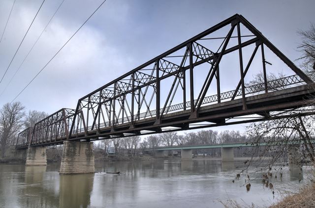
This bridge is a traditionally composed riveted Pratt through truss. It was bypassed by a new bridge and closed to traffic. It remains open to pedestrians with an unimproved trail leading south of the bridge, down the steep remains of what was originally a high earthen approach to the bridge for vehicular traffic. The bridge has a ten degree skew.
Information and Findings From DHPA Historic Bridge SurveyStatement of Significance As early as the 1820s, this crossing of the Wabash just north of Lafayette served as the only direct link between Lafayette and Battle Ground as well as the northern part of Tippecanoe county and northeastward to Logansport. The ferry operated from the 1820s until 1912 when the current bridge was constructed. In 1911, the Tippecanoe county commissioners hired Everett B. Vawter to draft plans for bridges at Davis Ferry and Jewettsport, in December paid him $1,000 for his work, and in February 1912, adopted his proposed plans. The board set letting for March at which point it received a number of bids on the county and two alternative plans--one in steel by the Lafayette Engineering Co. and one in concrete by Daniel Luten. The board accepted both alternative plans and awarded a contract to the lowest bidder, Lafayette Engineering on its own plan for $45,493. Lafayette Engineering sublet the contract abutments and piers to James M. Peirce of Delphi. In its plan, Lafayette Engineering followed Vawter's proposed structure of three 177-ft. 9-in. spans on a 10-degree skew for a total structure length of 540 ft. 9 in. Where Vawter designed for 2,200 lbs. of dead load and 1520 lbs. of live load per lineal foot, Lafayette Engineering planned for 1,950 lbs. of dead load and 1,280 lbs. of live load. Each of Lafayette's all-riveted, full-hip, Pratt through-trusses has a depth of 28 ft. and is subdivided into nine panels. The end-posts and top-chord members were fabricated from a pair of 12-in. channels (@20.5#), cover plate (16"x5/16"), and battens. The pair of channels in the lower-chord members grow in weight from the outer (@15#) to the central (@25#) panels. The truss webbing relies on connected angles. Laced double angles supply the verticals: the hip ones (2.5"x2.5") being lighter than the intermediate ones (5"x3"). Angles riveted together with stay plates provide the diagonals and are decreased in size toward midspan (from 6"x4" to 3"x2.5"). The trusses are stiffened with braced- A portal struts; 5-ft. deep latticed intermediate ones with knee braces; plus angle upper and lower lateral bracing. Riveted to the verticals above the lower chord, 20-in. I floor-beams (@65#) support six rows of 10-in. I beam stringers (@30#). Together the beams and stringers carry the 16-ft. concrete roadway. Latticed railings line the trusses. Although retired from vehicular service some years ago from a, long-standing, historically- significant crossing of the Wabash, this bridge retains its original members. The superstructure is rather unadorned, except for functionally/decoratively latticed struts and guardrails. The design is fairly standard for an early riveted truss except that the struts are heavier than usual. Angles have clearly replaced eyebars throughout. The skew is noteworthy. An important engineering firm revised the design of the structure and constructed the bridge. A key regional mason built the concrete substructure. Not listed in Mead & Hunt statewide inventory. Other Information References "Construction News, Engineering News-Record, 67: 171. Lafayette Engineering Co., Plan 2, Bridge Plans: Davis Ferry Bridge (Tippecanoe County Highway Department). James Peirce vs Lafayette Engineering, (31 January 1914), Box 76 (Tippecanoe County Historical Society). Tippecanoe County, "Commissioners Record," 30: 2, 133, 187, 332, 409, 449, 490-494; 31: 91, 95-96; 34: 338, 352. Everett B. Vawter, Bridge at Davis Ferry, (5 February 1912), Tippecanoe County Bridge Drawings (Tippecanoe County Historical Society). Dorothy Walden, "Davis Ferry part of history," Vertical File: Lafayette Bridges (Tippecanoe County Public Library). Bridge Considered Historic By Survey: Yes |
![]()
![]()
![]()
Coordinates (Latitude, Longitude):
Search For Additional Bridge Listings:
Bridgehunter.com: View listed bridges within 0.5 miles (0.8 kilometers) of this bridge.
Bridgehunter.com: View listed bridges within 10 miles (16 kilometers) of this bridge.
Additional Maps:
Google Streetview (If Available)
GeoHack (Additional Links and Coordinates)
Apple Maps (Via DuckDuckGo Search)
Apple Maps (Apple devices only)
Android: Open Location In Your Map or GPS App
Flickr Gallery (Find Nearby Photos)
Wikimedia Commons (Find Nearby Photos)
Directions Via Sygic For Android
Directions Via Sygic For iOS and Android Dolphin Browser
USGS National Map (United States Only)
Historical USGS Topo Maps (United States Only)
Historic Aerials (United States Only)
CalTopo Maps (United States Only)

© Copyright 2003-2024, HistoricBridges.org. All Rights Reserved. Disclaimer: HistoricBridges.org is a volunteer group of private citizens. HistoricBridges.org is NOT a government agency, does not represent or work with any governmental agencies, nor is it in any way associated with any government agency or any non-profit organization. While we strive for accuracy in our factual content, HistoricBridges.org offers no guarantee of accuracy. Information is provided "as is" without warranty of any kind, either expressed or implied. Information could include technical inaccuracies or errors of omission. Opinions and commentary are the opinions of the respective HistoricBridges.org member who made them and do not necessarily represent the views of anyone else, including any outside photographers whose images may appear on the page in which the commentary appears. HistoricBridges.org does not bear any responsibility for any consequences resulting from the use of this or any other HistoricBridges.org information. Owners and users of bridges have the responsibility of correctly following all applicable laws, rules, and regulations, regardless of any HistoricBridges.org information.
![]()