

View Information About HSR Ratings
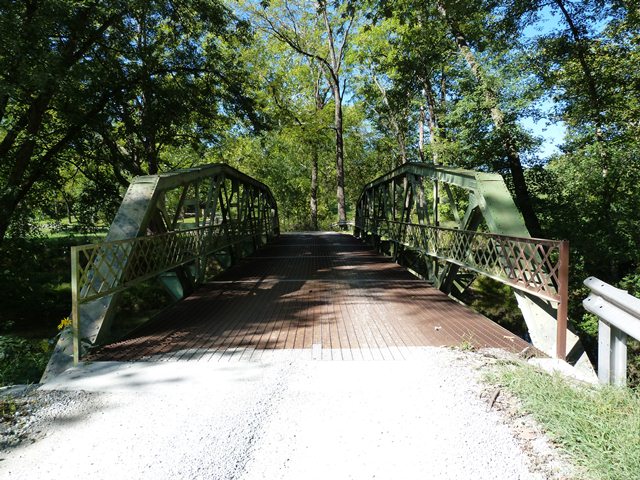
This bridge has an unusual shape and appearance due to the configuration of its panels. If it were a Pratt, it would be a Camelback truss with five slopes. The bridge is also unusual because its connections are bolted, rather than riveted as was more common at the time this bridge was built.
Information and Findings From DHPA Historic Bridge SurveyStatement of Significance Unusual as a form of the Warren pony, this bridge is rare for the parallel elements of the chords and atypical for the use of bolts and the integration of the verticals with the sway braces. The structure retains its original members, including the latticed guardrails. At 18', the panels of this bridge are tied for the widest on a Warren polygonal chord pony. Architectural Description The designers of this single-span Warren pony truss used a polygonal top chord. Parallel with the lower chord in the two most central panels, the top chord slopes once in each direction before meeting the endposts. Seated upon concrete abutments and wingwalls, the largely-bolted structure extends 90' in five panels. Its all-interior verticals and external sway braces are combined into a single member, using pairs of angles riveted together with stay plates. The diagonals are manufactured from a pair of angles (lighter ones toward midspan) riveted together with stay plates. The I floor beams are attached to gussets at the lower chord and carry the 14'9" concrete deck. Bridge Considered Historic By Survey: Yes |
![]()
![]()
![]()

![]()
![]()
![]()
Coordinates (Latitude, Longitude):
Search For Additional Bridge Listings:
Bridgehunter.com: View listed bridges within 0.5 miles (0.8 kilometers) of this bridge.
Bridgehunter.com: View listed bridges within 10 miles (16 kilometers) of this bridge.
Additional Maps:
Google Streetview (If Available)
GeoHack (Additional Links and Coordinates)
Apple Maps (Via DuckDuckGo Search)
Apple Maps (Apple devices only)
Android: Open Location In Your Map or GPS App
Flickr Gallery (Find Nearby Photos)
Wikimedia Commons (Find Nearby Photos)
Directions Via Sygic For Android
Directions Via Sygic For iOS and Android Dolphin Browser
USGS National Map (United States Only)
Historical USGS Topo Maps (United States Only)
Historic Aerials (United States Only)
CalTopo Maps (United States Only)

© Copyright 2003-2024, HistoricBridges.org. All Rights Reserved. Disclaimer: HistoricBridges.org is a volunteer group of private citizens. HistoricBridges.org is NOT a government agency, does not represent or work with any governmental agencies, nor is it in any way associated with any government agency or any non-profit organization. While we strive for accuracy in our factual content, HistoricBridges.org offers no guarantee of accuracy. Information is provided "as is" without warranty of any kind, either expressed or implied. Information could include technical inaccuracies or errors of omission. Opinions and commentary are the opinions of the respective HistoricBridges.org member who made them and do not necessarily represent the views of anyone else, including any outside photographers whose images may appear on the page in which the commentary appears. HistoricBridges.org does not bear any responsibility for any consequences resulting from the use of this or any other HistoricBridges.org information. Owners and users of bridges have the responsibility of correctly following all applicable laws, rules, and regulations, regardless of any HistoricBridges.org information.
![]()