

View Information About HSR Ratings

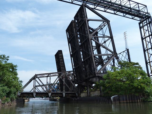
This is a pair of identical bridges that sit directly beside each other, today abandoned in the raised position. This pair of bridges was built ca. 1909, along with two more identical bridges which have since been demolished. The four bridges were built by three different railroad companies that had agreed to seek a common builder for their bridges. These railroad companies included the Pittsburgh, Fort Wayne, and Chicago Railway (Pennsylvania Railroad), Baltimore and Ohio Railroad, and the Lake Shore and Michigan Southern Railway (New York Central). Two bridges were built for the Lake Shore and Michigan Southern Railway, and those are the two which stand today. The three railroad companies settled on building Rall bascule bridges.

Rall bascule bridges were invented by Theodor Rall. Exact design of a Rall bascule bridge can vary, but should include some of the characteristics in one of the two patents filed by Mr. Rall, which include patent #669,348 and #817,516, which are listed above. The key feature among all known surviving Rall bascule bridges is a trunnion that is set inside a roller that moves along a track during bridge operation, which means under operation the bridge has a moving center of gravity. The rights to build Rall bascule bridges were held by the Strobel Steel Construction Company of Chicago, Illinois, which was a company that both designed and contracted for bridge projects. As such, most Rall bridges were both designed and built by Strobel Steel Construction Company. Currently, there are five known Rall bascule bridges: One in Chicago, Illinois, these two bridges in East Chicago, Indiana, one in Portland, Oregon, and one in Baltimore, Maryland. A full list can be viewed on BridgeHunter. Because of their highly unusual design as well as their rarity, each surviving Rall bascule bridge should be considered to have an extremely high level of significance and should be given a high level of preservation priority.
These two bridges crossing the canal have a design that draws features from both the first and second Rall bascule bridge patents. The design of a trunnion positioned inside a roller that runs along a track as defined in the first patent is followed here. However, the bridge also has some details that are only shown in the second patent, and indeed these bridges are the only known Rall bascule bridges that display some features shown in the second Rall bascule patent. These details include an extremely unusual pair of operating struts that stick out away from the rest of the bridge. When raised, these operating struts actually stick straight up into the air. Just like it shows in the patent, these operating struts have a lattice portal bracing that connects the to the two struts. The operating struts contain a rack that is engaged by an operating pinion. Also as shown in the second patent, the truss includes a curved detail that allows the truss to bear on a substructure over a "shoe pin" on the machinery end of the leaf when the bridge is lowered. The far end of the leaf rests on a fixed bearing when lowered. As such, when lowered the fixed bearings at each end of the leaf take the entire load, which would free the roller and allow the roller to be replaced while the bridge is lowered. These bridges however do not follow the roller design shown in the second patent, and instead stick to the design shown in the original patent. The second patent outlined a roller that was only a partial circle and therefore would not have rotated 360 degrees during operation. This partial circle design would have made that portion of the bridge look somewhat like a Scherzer rolling lift bascule.
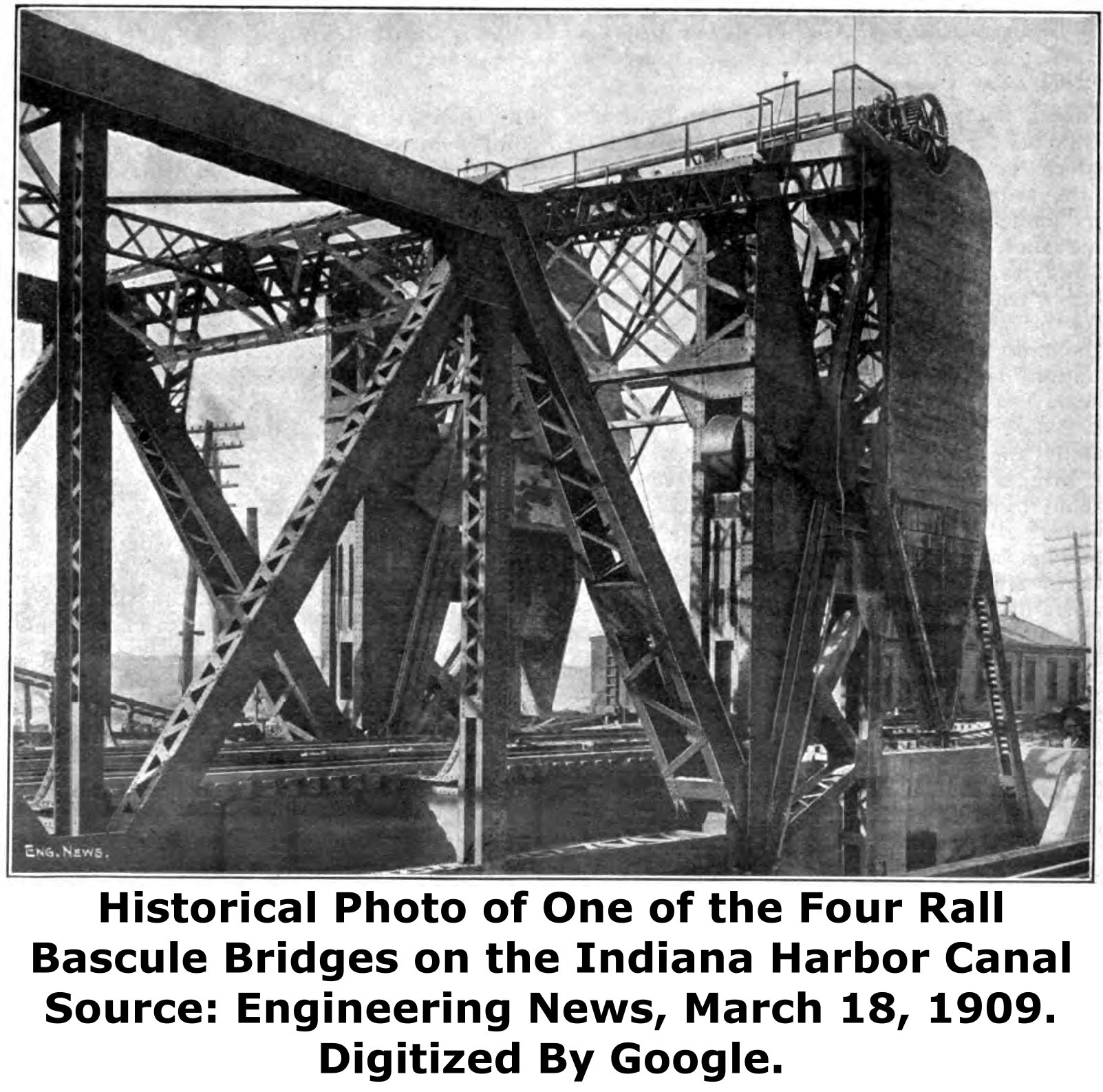
Some other design details of these two bridges are noteworthy. The lower portion of the counterweight was designed with cast iron blocks, but the upper portion was designed of concrete with pig iron embedded. The main rollers for the bridge have a diameter of 55 inches and are 25 inches wide. The bridge was originally operated with two 35 horsepower 220 volt d/c motors. However, only 25 horsepower was normally required to operate the bridge. Strobel Steel Construction Company both designed and built the bridges. The Pennsylvania Steel Company of Steelton, Pennsylvania fabricated the structural steel. The machinery and electrical contractor was George P. Nichols and Brother of Chicago, Illinois. The substructures for the bridges were designed by the respective railroad companies. Albert Lucius of New York, New York served as a joint consulting engineer for all the railroad companies.
These bridges have been abandoned. They are located deep in a privately owned area of heavy industry, along with several other nearby historic railroad bridges. The only reliable, legal way for the public to visit them is to take a boat on the canal, or briefly glance them out of the typically dirty windows of the Amtrak trains that cross a nearby bridge. Because abandoned railroad bridges located in inaccessible industrial areas tend to generate little public awareness, and because railroad bridge owners often do not see the substantial cultural value in leaving an abandoned historic bridge standing, these extremely significant historic bridges should be considered to be at some risk for demolition. The loss of these bridges would be devastating given their rarity nationwide and the fact that these bridges have some design details not found in the few other Rall bascule bridges that survive.

These bridges were built before the canal began operation and so temporary fixed bridges provided a railroad crossing during construction.
The northeastern-most Rall bascule bridge was lowered at least as recently as 1993 according to this photo.
Thanks to Tom Winkle for providing boat transportation to assist in the photo-documentation of this historic bridge.

![]()
![]()
![]()
Coordinates (Latitude, Longitude):
Search For Additional Bridge Listings:
Bridgehunter.com: View listed bridges within 0.5 miles (0.8 kilometers) of this bridge.
Bridgehunter.com: View listed bridges within 10 miles (16 kilometers) of this bridge.
Additional Maps:
Google Streetview (If Available)
GeoHack (Additional Links and Coordinates)
Apple Maps (Via DuckDuckGo Search)
Apple Maps (Apple devices only)
Android: Open Location In Your Map or GPS App
Flickr Gallery (Find Nearby Photos)
Wikimedia Commons (Find Nearby Photos)
Directions Via Sygic For Android
Directions Via Sygic For iOS and Android Dolphin Browser
USGS National Map (United States Only)
Historical USGS Topo Maps (United States Only)
Historic Aerials (United States Only)
CalTopo Maps (United States Only)

© Copyright 2003-2024, HistoricBridges.org. All Rights Reserved. Disclaimer: HistoricBridges.org is a volunteer group of private citizens. HistoricBridges.org is NOT a government agency, does not represent or work with any governmental agencies, nor is it in any way associated with any government agency or any non-profit organization. While we strive for accuracy in our factual content, HistoricBridges.org offers no guarantee of accuracy. Information is provided "as is" without warranty of any kind, either expressed or implied. Information could include technical inaccuracies or errors of omission. Opinions and commentary are the opinions of the respective HistoricBridges.org member who made them and do not necessarily represent the views of anyone else, including any outside photographers whose images may appear on the page in which the commentary appears. HistoricBridges.org does not bear any responsibility for any consequences resulting from the use of this or any other HistoricBridges.org information. Owners and users of bridges have the responsibility of correctly following all applicable laws, rules, and regulations, regardless of any HistoricBridges.org information.
![]()