

View Information About HSR Ratings
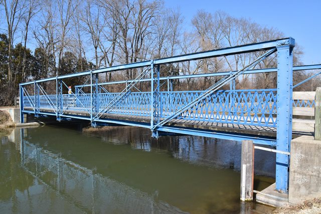
This is one of the oldest and most impressive examples of a rare bedstead truss bridge in the country. Most bedstead truss bridges date from 1890 to 1910. This 1879 example is well before that period and dates to the historically noteworthy experimental period of metal truss bridge design. It is also notable as a work of the Wrought Iron Bridge Company, which does not appear to have built this bridge type frequently especially in this period. The bridge is also noted as a longer example of a bedstead pony truss spans. This bridge type was normally used for very short truss spans.
This bridge has been relocated and beautifully preserved here in Indianapolis.
Information and Findings From DHPA Historic Bridge SurveyStatement of Significance Montgomery County Locations CR 475E, which crossed Lye Creek, had linked Darlington with the Lye Creek Prairie and its churches since the mid-nineteenth century. Lye Creek near Jonathan Winter's residence was probably spanned with a timber structure before 1889 when the county commissioners decided to move an 1879 Wrought Iron Bridge Company bedstead here and to append an I-beam approach to it. The board first hired Daniel Milner to build an abutment on the northwest of boulders laid in cement. The county furnished the stone and the cement, and Milner laid the masonry for $1.75 per cubic yard. Then the board contracted with I. A. Shriver for $298 to erect the bedstead with one set of legs astride Milner's stone abutment and the other anchored to bedrock as a pier to which the I-beam approach was attached. The southeast end of the structure rested directly on an out-cropping of bedrock. Exactly where in the county the Wrought Iron Bridge Company had originally erected the bedstead remains a mystery. The pin-connected truss leg or Pratt bedstead pony trusses were made of wrought iron members connected with a number of cast iron shoes and blocks. The span extends 70 ft. in five panels and has a 19-ft. I-beam approach added to the southeast. The vertical end-posts and top chord members of the pony are fabricated of a pair of channels riveted together with a cover plate and battens. The outer panel of the lower chord also relies on a pair of angles and battens; the interior ones rely on a pair of die-forged eyebars. The verticals consist of latticed Ts riveted on their ends to pin plates. A pair of die-forged rectangular eyebars supply the diagonals except in the center panel where round rod with turnbuckles and loop-welded ends double as diagonal and counter. Variable-depth girders are U-bolted to the lower pins as floor-beams. They supported rows of steel stringers which carried the 16-ft. timber roadway. Latticed rails lined the trusses; double-sized ones bordered the outer approach perimeter. The floor-beams and the truss legs were X- braced with round, adjustable rod as some protection against sway. This fairly long wrought and cast iron bedstead, designed and fabricated by a major Ohio firm, is probably the oldest extant one in Indiana. The structure retains its original members, including latticed guardrails of different sizes for the two spans. Indianapolis Greenways Location The pony-truss span was removed from its second home in 1999 to be restored and relocated in 2000 on the Indianapolis Greenways system. Restoration of the superstructure retained all the original truss members and floor-beams with modest repairs and shortening of the legs for seating on new concrete abutments. The stringers and deck are new. The original approach rails served as a model for replacements modified to meet contemporary code for pedestrian use by moving the lattice bars closer together. The cast iron name and date plates are replicas of the originals. Other Information References: Montgomery County Records Butler, Fairman and Seufert, Inc., Bridge Inspection/Reinspection Report: Montgomery County (Indianapolis, 1973, 1978). bridge name and date plates. Indiana Historic Sites & Structures Inventory, Montgomery County: Interim Report (Indianapolis, 1986), 30-31. Montgomery Co., "Commissioners Record," 19: 90-91, 97, 99. Bridge Considered Historic By Survey: Yes |
![]()
![]()
![]()
Coordinates (Latitude, Longitude):
Search For Additional Bridge Listings:
Bridgehunter.com: View listed bridges within 0.5 miles (0.8 kilometers) of this bridge.
Bridgehunter.com: View listed bridges within 10 miles (16 kilometers) of this bridge.
Additional Maps:
Google Streetview (If Available)
GeoHack (Additional Links and Coordinates)
Apple Maps (Via DuckDuckGo Search)
Apple Maps (Apple devices only)
Android: Open Location In Your Map or GPS App
Flickr Gallery (Find Nearby Photos)
Wikimedia Commons (Find Nearby Photos)
Directions Via Sygic For Android
Directions Via Sygic For iOS and Android Dolphin Browser
USGS National Map (United States Only)
Historical USGS Topo Maps (United States Only)
Historic Aerials (United States Only)
CalTopo Maps (United States Only)

© Copyright 2003-2024, HistoricBridges.org. All Rights Reserved. Disclaimer: HistoricBridges.org is a volunteer group of private citizens. HistoricBridges.org is NOT a government agency, does not represent or work with any governmental agencies, nor is it in any way associated with any government agency or any non-profit organization. While we strive for accuracy in our factual content, HistoricBridges.org offers no guarantee of accuracy. Information is provided "as is" without warranty of any kind, either expressed or implied. Information could include technical inaccuracies or errors of omission. Opinions and commentary are the opinions of the respective HistoricBridges.org member who made them and do not necessarily represent the views of anyone else, including any outside photographers whose images may appear on the page in which the commentary appears. HistoricBridges.org does not bear any responsibility for any consequences resulting from the use of this or any other HistoricBridges.org information. Owners and users of bridges have the responsibility of correctly following all applicable laws, rules, and regulations, regardless of any HistoricBridges.org information.
![]()