

View Information About HSR Ratings

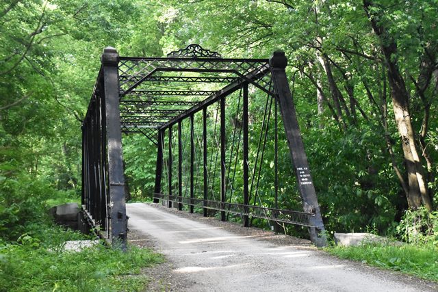
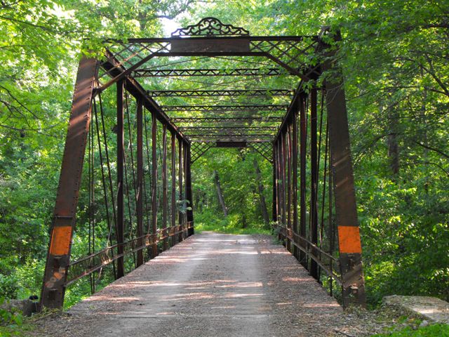
This bridge is an extremely rare surviving example of a hybrid truss that combines the Whipple and Pratt truss configuration. The main diagonals follow the Pratt configuration, with the counters following the Whipple configuration. This truss design was part of an 1876 patent filed by Wrought Iron Bridge Company owner David Hammond. The company built many truss bridges that list this patent on them, but most of them do not actually follow the hybrid truss configuration displayed in the original patent file, and instead display either a true Whipple or Pratt.
Traditional information sources do not specify a specific name for the truss configuration, however since most truss configurations are named after the person who patented them, HistoricBridges.org lists the truss configuration as the "Hammond" truss configuration.
Be sure to view the Bertram Road Bridge page for the most complete discussion of the Wrought Iron Bridge Company and the Hammond truss configuration.
The CR-325 West Bridge is an excellent example of this extremely rare truss configuration in Indiana. It retains good historic integrity including original floorbeams that follow a design used by the company for bridges it built in the 1870s. These floorbeams include decorative flower castings at the ends of each beam. The railings are an unusual lightweight hub-guard design.
Needless to say, this nationally significant bridge, one of the last surviving examples of a design patented by the leading iron bridge builder, should receive the highest preservation priority.
In 2015, this bridge was thankfully restored. The bridge remains in good condition today, with the exception of one vertical member which is bent.
The river this bridge crosses was the subject of a project to create a straighter channel, which resulted in a second bridge being built a short distance north of this bridge in 1924. Today, these two bridges form a Historic District.
Information and Findings From DHPA Historic Bridge SurveyStatement of Significance Built on a patented design by a prolific and famous Ohio firm, this structure is the best of two such hybrids remaining in the state. It retains most of its original members including decoratively latticed portals with bracing and a cast iron decoration above the nameplate. Architectural Description Designed after the Wrought Iron Bridge Company's patent of 21 Nov. 1876, this structure combines certain features of the standard single and double intersection through trusses. In particular, its diagonals extend across two panels when angled towards the span's end and only one when angled towards the span's center. Most two-panel diagonals are cylindrical with turnbuckles; most single-panel diagonals are doubled and square. The 120' span of nine panels has intermediate verticals of crafted and rolled I beams which are lighter toward center span. U-bolted to the lower pins, the girder floor beams support a wooden deck with a 13'9" roadway and 15'5" of vertical clearance. Abutments and wingwalls are concrete. Bibliography: Morrison, Lowell E., Bridge Inspection Survey and
Report of Gibson County (Princeton, 1974). Additional Notes From Dr. James Cooper on Previous Bridges At This Location: Another tidbit that surfaced when I was combing through some of my old notes the other day was this fragmentary mention, in Nora Hawbaker's chapter on "Transportation" in Ruth McClellan's Pike County History Bicentennial Edition: "In 1846 a resolution was adopted to build a bridge across the Patoka River on the Evansville road, not to exceed $250.00. In 1860 Pike County paid $530.95 for building a bridge across the Patoka River at Dongola. In 1881, Gibson and Pike county built bridges over stream (sic) on county lines." God only knows what sources she was using for this information -- the author herself doesn't tell us. But it is interesting to think the county was building a bridge at Dongola in 1860 -- and that it MIGHT have replaced an even earlier structure, if one was in fact built as an immediate follow-up to the "resolution" of 1846...(maybe some of those fireworks Cockrum and company were using to scare slave-hunters got out of control...). -- Edith Sarra, December 2012 e-mail. Pike County paid Jonathan Loveless $68.58 in December 1874 for labor and materials "on Dongola Bridge." J. J. Bowman received $1 at the same time "for nails furnished for Dongola Bridge." The nails underline the likelihood that this was at least in part a timber structure. In June 1875, Pike paid J. Morris $15 "for clearing drift away from Bridge across the Patoka River at Dongola." Drift was a particular issue for timber beam structures that obstructed the waterway more than trussed ones. In October, 1875, the Pike County commissioners authorized one of their own -- John J. Bowman -- "to build a culvert near the Dongola Bridge in Logan township." More "repairs on Pakoka Bridge near Dongola" occurred in 1877. Pike County paid Jonathan Loveless $20.80 for same in March. Additional Notes From Dr. James Cooper on Current Bridge At This Location: The decision to replace the old Dongola Bridge occurred in fits and starts over a number of years. In September 1877, for example, the Pike County Commissioners received a call for a joint-board meeting in the following month with the Gibson County board to consider "the erection of a new Bridge across the Patoka River at Dongola." Dongola folk probably spear-headed the successful March 1881 petition drive to the commissioners. The Gibson board subsequently had the auditor notify their Pike county counterparts again of willingness to build a new bridge across the Patoka. The Pike board responded favorably and apparently presumed that the Gibson commissioners were thinking of a timber structure on the county line. The two boards met jointly in early September 1881. "There being a highway on both sides of said river which would be connected by said bridge," the general location was clear enough. But there was much left to be discussed and agreed upon. The boards appointed Alexander H. Polk, the Gibson county surveyor, to prepare estimates, plans, and specifications for a new structure and to present them at a joint-board meeting scheduled for later in the month at the home of Thomas Jones who lived south of the Patoka. The boards would then jointly "determine the kind of bridge that shall be erected; also ... appoint one or more persons as superintendents of said proposed work; also ... make the necessary appropriations for building the same in equitable proportion to the whole amount of taxable property in said counties." The location of the meetings and the agent put in charge show clearly that Gibson was acting as the lead county, a matter that all probably regarded as appropriate since Gibson had the lion's share of the "taxable property." The boards jointly settled the outstanding issues at the 20th of September meeting. The structure would be "an Iron truss bridge with stone abutments" built to A. H. Polk's plans and specifications. Polk was named to "superintend erection of same." Gibson would pay 75% and Pike 25% of the estimated $7,000 cost. The County Line Bridge (as the Gibson authorities called it) or the Dongola Bridge (as Pike county officials preferred) dropped out of the records for some time after the decisions of late September 1881. Indeed, the minutes of neither board of commissioners provide much significant information about contracting. Polk's role of superintendent of erection must have included arrangements for bidding and contracting for the substructure and superstructure as well as oversight of construction itself, and he did not seem to be in any hurry. The first reference in any minutes appear in December 1883 when the Gibson board approved, first, payment of $150 to Polk "for his services as superintendent" on the County Line Bridge, and, then, of $65 "for services as engineer and superintendent of earth work and masonry at Severns and County Line Bridges." If the bridge substructure was being built in the second half of 1883, maybe not even the contracting was completed in 1882. In an early July 1884 accounting to the Gibson board, Polk identified "Messrs Godman and Winslow as the contractors for said substructure." A month later, he speaks of the "Wrought Iron Bridge Company." Out of the overall budget of $7,000 for the County Line Bridge, Polk placed the cost of the substructure, which must have been of cut stone, at $3,556. It remains unclear to whom Godman and Winslow subcontracted the masonry abutments. In his final and brief accounting, Polk noted $2,864,03 as "yet due to the Wrought Iron Bridge Company" which was either the full or part-payment owned for the superstructure. The "masonry and superstructure of said bridge has been completed (the earth work being in course of construction)," Polk reported in early August of 1884. Designed after the Wrought Iron Bridge Company's patent of 21 Nov. 1876, the structure constructed combines certain features of the standard single and double intersection through trusses. In particular, its diagonals extend across two panels when angled towards the span's end and only one when angled towards the span's center. Most two-panel diagonals are cylindrical with turnbuckles; most single-panel diagonals are doubled and square. The trusses have intermediate verticals of crafted and rolled I beams which are lighter toward center span. U-bolted to the lower pins, the girder floor-beams support runs of steel stringers -- replacements for the original timber ones -- and a timber roadway between latticed hub-guards and with 15-feet and 5-inches of vertical clearance. The original stone abutments and and wing-walls have been encased in or replaced with concrete. For more detailed structural description, see Cooper, "Crossing Patoka Bottoms." Major repairs were made to this bridge in 1910 when Alonzo W. Kinman of Peterburg won a $3,660 contract which included flooring and I-beams. The job probably included shifting from timber to metal stringers, replacing the timber deck, and, possibly, encasing the cut-stone abutments in concrete. There was a small repair to the Dongola Bridge in 1924. Downey Coleman of Gibson County won a contract for $320. Built on a patented design by a prolific and famous Ohio firm, this structure is the best of two such hybrids remaining in the state. It retains most of its original members including decoratively latticed portals with bracing and a cast iron decoration above the nameplate. References Morrison, Lowell E., Bridge Inspection Survey and Report of Gibson County (Princeton, 1974). United Consulting Engineers, Inc., Bridge Reinspection Report for Pike County (Indianapolis, 1980). Gibson County, "Commissioners Record," I: 278, 370-371, 400; J: 419, 427; L: 78, 104, 146; Y: 123. Pike County, "Commissioners Record," J: 93, 97, 245, 335; K: 7, 113; L: 380-382, 442, 498-499; M: 450; T: 372-378; Y: 203-208. bridge nameplate. Edith Serra, "The Patoka River bridges at Dongola, Indiana: Historical contexts." James L. Cooper, "Crossing the Patoka Bottoms: The Dongola Bridges" (2003). Local Matters," Princeton Clarion, 22 September 1881: p4 c2. Bridge Considered Historic By Survey: Yes |
![]()
![]()
![]()
![]()
![]()
Coordinates (Latitude, Longitude):
Search For Additional Bridge Listings:
Bridgehunter.com: View listed bridges within 0.5 miles (0.8 kilometers) of this bridge.
Bridgehunter.com: View listed bridges within 10 miles (16 kilometers) of this bridge.
Additional Maps:
Google Streetview (If Available)
GeoHack (Additional Links and Coordinates)
Apple Maps (Via DuckDuckGo Search)
Apple Maps (Apple devices only)
Android: Open Location In Your Map or GPS App
Flickr Gallery (Find Nearby Photos)
Wikimedia Commons (Find Nearby Photos)
Directions Via Sygic For Android
Directions Via Sygic For iOS and Android Dolphin Browser
USGS National Map (United States Only)
Historical USGS Topo Maps (United States Only)
Historic Aerials (United States Only)
CalTopo Maps (United States Only)

© Copyright 2003-2024, HistoricBridges.org. All Rights Reserved. Disclaimer: HistoricBridges.org is a volunteer group of private citizens. HistoricBridges.org is NOT a government agency, does not represent or work with any governmental agencies, nor is it in any way associated with any government agency or any non-profit organization. While we strive for accuracy in our factual content, HistoricBridges.org offers no guarantee of accuracy. Information is provided "as is" without warranty of any kind, either expressed or implied. Information could include technical inaccuracies or errors of omission. Opinions and commentary are the opinions of the respective HistoricBridges.org member who made them and do not necessarily represent the views of anyone else, including any outside photographers whose images may appear on the page in which the commentary appears. HistoricBridges.org does not bear any responsibility for any consequences resulting from the use of this or any other HistoricBridges.org information. Owners and users of bridges have the responsibility of correctly following all applicable laws, rules, and regulations, regardless of any HistoricBridges.org information.
![]()