

View Information About HSR Ratings

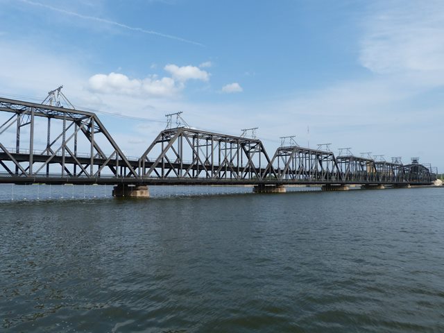
This highly significant and unusual bridge is a double-deck structure. It carries two railroad lines on top, and vehicular/pedestrian traffic on the lower deck. The bridge is configured as follows: One pin connected Pratt through truss, carrying only the railroad (9 panels, 198.5 feet), five double-deck pin-connected Baltimore through truss spans (end spans 12 panels, 258 feet, middle three spans 10 panels, 216 feet), one double-deck pin-connected Baltimore through truss swing span (16 panels, 365.6 feet), and one pin connected Pratt through truss, carrying only the railroad (5 panels, 98.7 feet). The end truss spans enable the separation/merging of the upper and lower decks of the bridge into the same footprint. Because this was both a wide and heavy bridge, the typical rack and pinion method for operating the swing span was not used out of fear that the stress on the teeth to move such a big bridge would cause them to break. Instead, a giant chain gear system was used. This type of system is not commonly found on swing bridges. Constructed in 1896, the bridge is an old, and highly complex historic truss bridge that has a high level of technological significance.

The bridge is also historically significant because it was designed by Ralph Modjeski. It was the first major bridge that he was chief engineer for. In the 20th Century Ralph Modjeski became a famous bridge engineer and designed some of the greatest bridges in the country. Even many large bridges that he did not design directly would still be influenced by him since engineers would hire him as a consultant to review their plans. This bridge is therefore significant becuase it represents the beginning of an important bridge engineer's career. The mechanical aspects of the bridge were designed by Byron B. Carter who worked for Modjeski. This is also noteworthy because Carter was along with Modjeski one of the three consulting engineers who recommended the fixed trunnion type of bascule bridge to the City of Chicago a general design that was soon after adopted by many communities across the country.

The bridge replaced an existing bridge at the exact same location. The substructure from the previous bridge was strengthened, modified and reused for the new bridge. Erection of the truss was accomplished by use of a traveler. The bridge was built one span at a time, replacing the old bridge spans one at a time as well, to minimize traffic disruption on the railroad line. Railroad closure for the whole project was only five days and this was due to a disaster that occurred during construction. Ice built up against the falsework that was holding up the under-construction swing span. The men working on the bridge were ordered off just in time as the ice swept away the falsework, carrying away the partially completed swing span and the traveler as well. Although railroad traffic was only interrupted for five days before falsework could be erected, this delayed the overall project by a few months and a temporary lift span was installed to accommodate boats during this period.
The bridge is unusual because it was ordered built by the U.S. Army who continues to own the bridge to this day. Despite the army ownership, the bridge is open to the public.
This swing span is reportedly operated in a manner where it rotates 360 degrees. This is highly unusual for a swing bridge. Usually they only rotate 90 degrees, and therefore must reverse their movement to close. This 360 operation was reportedly made possible in case wind conditions made it difficult to operate it in a particular direction. The design also might have helped it open and close more quickly.
As is typical with large bridges, a variety of sources give a variety of dimensions for the bridge. Additionally, the length of this bridge can vary depending on whether you measure the railroad deck of the lower deck. The measurements for total length given by HistoricBridges.org are for the upper deck. The total length measurement and the span lengths given by HistoricBridges.org all came from the report compiled by Ralph Modjeski. Since he designed the bridge, these seemed to be the most reliable measurements to use.

Above: This photo shows the previous bridge at this location.

Above: This photo shows to the right the new spans being constructed, the old spans of the previous bridge to the left, and in the center the traveler resting on temporary falsework as a new fixed truss span was being built.


Above: These photos show the construction traveler used to build the bridge. In the photo to the right a partially completed truss span is clearly visible. To the right of the partially completed truss section you can see eyebars for a diagonal member that have yet to be attached to other members.


Above: The photo to the left shows the under-construction swing span after it was destroyed by an icy flood. To the right is the temporary lift span in raised position that was used following the collapse.


This bridge is tagged with the following special condition(s): Double-Deck
![]()
![]()
![]()
Coordinates (Latitude, Longitude):
Search For Additional Bridge Listings:
Bridgehunter.com: View listed bridges within 0.5 miles (0.8 kilometers) of this bridge.
Bridgehunter.com: View listed bridges within 10 miles (16 kilometers) of this bridge.
Additional Maps:
Google Streetview (If Available)
GeoHack (Additional Links and Coordinates)
Apple Maps (Via DuckDuckGo Search)
Apple Maps (Apple devices only)
Android: Open Location In Your Map or GPS App
Flickr Gallery (Find Nearby Photos)
Wikimedia Commons (Find Nearby Photos)
Directions Via Sygic For Android
Directions Via Sygic For iOS and Android Dolphin Browser
USGS National Map (United States Only)
Historical USGS Topo Maps (United States Only)
Historic Aerials (United States Only)
CalTopo Maps (United States Only)

© Copyright 2003-2024, HistoricBridges.org. All Rights Reserved. Disclaimer: HistoricBridges.org is a volunteer group of private citizens. HistoricBridges.org is NOT a government agency, does not represent or work with any governmental agencies, nor is it in any way associated with any government agency or any non-profit organization. While we strive for accuracy in our factual content, HistoricBridges.org offers no guarantee of accuracy. Information is provided "as is" without warranty of any kind, either expressed or implied. Information could include technical inaccuracies or errors of omission. Opinions and commentary are the opinions of the respective HistoricBridges.org member who made them and do not necessarily represent the views of anyone else, including any outside photographers whose images may appear on the page in which the commentary appears. HistoricBridges.org does not bear any responsibility for any consequences resulting from the use of this or any other HistoricBridges.org information. Owners and users of bridges have the responsibility of correctly following all applicable laws, rules, and regulations, regardless of any HistoricBridges.org information.
![]()