

View Information About HSR Ratings
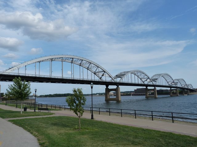
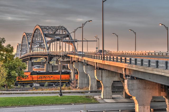
This impressive and distinctive landmark bridge was the first tied arch bridge to cross the Mississippi River. Many tied arch bridges only have a single main span, therefore this bridge is unusual among tied arch bridges because it has five spans. From north to south there are two 395 foot arch spans, two 538 foot arch spans, and one 395 foot arch span. The bridge also features a series of steel stringer approach spans. The northern (Iowa) approach is quite a bit longer. This bridge was designed by the firm Howard, Needles, Tammen, and Bergendoff. However, one of this firm's employees, Ned L. Ashton played a major role in the design of this bridge and is considered a noteworthy bridge engineer in Iowa history.
This bridge was originally a toll bridge when built. Tolls were apparently collected right in the middle of the bridge. Today, only the canopy that was built over the toll booths remains today. The five arches of this bridge are reportedly used to symbolize the five largest cities in the "Quad Cities" area with the largest two spans representing specifically the two largest cities which are Davenport and Rock Island, and which this bridge also connects. This bridge was originally going to be named the Galbraith Bridge after Robert Galbraith, the Rock Island mayor at the time. The official name of the bridge is the Rock Island Centennial Bridge.
Couse and Saunders of Detroit, Michigan was the contractor for the original concrete deck. This bridge was rehabilitated in 1996 and again in 2005.
In 2005, the bridge was given by the city of Rock Island to the Illinois Department of Transportation. It is hoped that IDOT will maintain and preserve this historic bridge. Currently in good condition, this is a rare historic bridge and a symbol for the area. It does not deserve to have its maintenance deferred and later be demolished and replaced like many of the bridges that IDOT is responsible for.
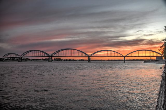
Information and Findings From Iowa's Historic Bridge InventoryDiscussion of Bridge Of the myriad bridges crossing the wide murky Mississippi river, the Centennial Bridge, connecting Davenport, Iowa, and Rock Island, Illinois, claims the distinction of being the first tie-arch form bridge across the Mississippi River. Furthermore, the project's design, construction, and financial backing define its significance on several distinct levels. Approval by the commission of the bridge design drawn up by the Kansas City engineering firm of Howard, Needles, Tammen, and Bergendoff was finalized in late winter of 1939. In April the commission let the foundation contract to McCarthy Improvement Company of Davenport, Iowa. Construction began the same month and McCarthy was fortunate to discover, during the pier-building process, that individual piers could be founded on solid bedrock, either limestone or blue shale rock. Progressing rapidly, American finished its work early in 1940 and the bridge officially opened for traffic on 21 July 1940. Since its construction, the Centennial Bridge's only major alteration of note is that it currently operates as a free crossing instead of a toll bridge. Barring this planned conversion, the Mississippi River bridge carries heavy traffic while retaining an exceptionally high degree of structural and historical integrity. One of the primary designers working for Howard, Needles, Tammen, and Bergendoff of Kansas City, Edward Ashton of Iowa City, was responsible of many of Centennial Bridge's unique attributes. This structure combined Ashton's inherent thriftiness with his vision of simplistic beauty. The clean lines and lack of ornamentation of the tied arch configuration proved to be both cost efficient and visually striking. As far as aesthetics was concerned, Ashton particularly admired the view of the trusses as one approached the main spans. The simple massiveness of the structure makes a strong statement about how Ashton felt bridges should appear. The Centennial Bridge is a significant Iowa highway-related resource for several reasons. The structure is historically important as in important crossing of a major Midwestern river. The Centennial Bridge is technologically significant as the first tied-arch span across the Mississippi River--a nationally important example of this inherently long-span design. And, considered by Ashton to be the best bridge he had ever designed, this gracefully proportioned structure is significant for its association with one of Iowa's most influential engineers [adapted from Crow-Dolby 1992]. Bridge Considered Historic By Survey: Yes |
This bridge is tagged with the following special condition(s): Unorganized Photos
![]()
![]()
![]()
![]()
![]()
Coordinates (Latitude, Longitude):
Search For Additional Bridge Listings:
Bridgehunter.com: View listed bridges within 0.5 miles (0.8 kilometers) of this bridge.
Bridgehunter.com: View listed bridges within 10 miles (16 kilometers) of this bridge.
Additional Maps:
Google Streetview (If Available)
GeoHack (Additional Links and Coordinates)
Apple Maps (Via DuckDuckGo Search)
Apple Maps (Apple devices only)
Android: Open Location In Your Map or GPS App
Flickr Gallery (Find Nearby Photos)
Wikimedia Commons (Find Nearby Photos)
Directions Via Sygic For Android
Directions Via Sygic For iOS and Android Dolphin Browser
USGS National Map (United States Only)
Historical USGS Topo Maps (United States Only)
Historic Aerials (United States Only)
CalTopo Maps (United States Only)

© Copyright 2003-2024, HistoricBridges.org. All Rights Reserved. Disclaimer: HistoricBridges.org is a volunteer group of private citizens. HistoricBridges.org is NOT a government agency, does not represent or work with any governmental agencies, nor is it in any way associated with any government agency or any non-profit organization. While we strive for accuracy in our factual content, HistoricBridges.org offers no guarantee of accuracy. Information is provided "as is" without warranty of any kind, either expressed or implied. Information could include technical inaccuracies or errors of omission. Opinions and commentary are the opinions of the respective HistoricBridges.org member who made them and do not necessarily represent the views of anyone else, including any outside photographers whose images may appear on the page in which the commentary appears. HistoricBridges.org does not bear any responsibility for any consequences resulting from the use of this or any other HistoricBridges.org information. Owners and users of bridges have the responsibility of correctly following all applicable laws, rules, and regulations, regardless of any HistoricBridges.org information.
![]()