

View Information About HSR Ratings
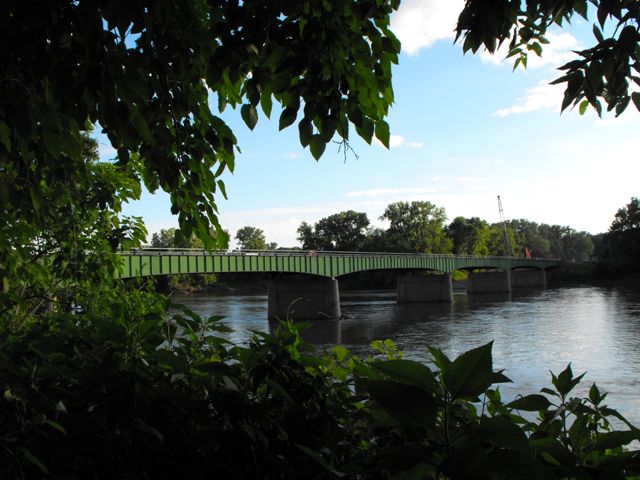
The Farmington Bridge is an excellent example of a standard plan deck plate girder with haunched girders that give the bridge a highly attractive arched appearance. Iowa appears to have built a number of girder bridges following this plan, but the Farmington Bridge appears to be among the largest remaining examples. The bridge also has excellent historic integrity. Iowa's deck plate girder bridge design as seen here positions the girders in an uncommon configuration where the girders are placed outside the edge of the deck, allowing for them to rise up above the deck slightly. This is done to allow them to double as the base of a guardrail system. The tops of the girders have pole rails mounted on them, completing the guardrail function.
There is a similarly designed and configured structure of this type at the other corner of the county, crossing Des Moines River between the communities of Leando and Douds. However that bridge was built in 1954, while the Farmington Bridge was built in 1948 making it the older of the two At least some of the largest and most impressive examples of this bridge type should be selected for preservation. The graceful arch-like shapes and the riveted girders make these bridges more attractive than a modern bridge and represent a bridge type and construction that is no longer employed today.
The Farmington Road Bridge was demolished and replaced in 2013. This is most unfortunate since the bridge is an attractive structure that documents mid-20th Century bridge construction in Iowa quite well.
![]()
![]()
![]()
This historic bridge has been demolished. This map is shown for reference purposes only.
Coordinates (Latitude, Longitude):
Search For Additional Bridge Listings:
Bridgehunter.com: View listed bridges within 0.5 miles (0.8 kilometers) of this bridge.
Bridgehunter.com: View listed bridges within 10 miles (16 kilometers) of this bridge.
Additional Maps:
Google Streetview (If Available)
GeoHack (Additional Links and Coordinates)
Apple Maps (Via DuckDuckGo Search)
Apple Maps (Apple devices only)
Android: Open Location In Your Map or GPS App
Flickr Gallery (Find Nearby Photos)
Wikimedia Commons (Find Nearby Photos)
Directions Via Sygic For Android
Directions Via Sygic For iOS and Android Dolphin Browser
USGS National Map (United States Only)
Historical USGS Topo Maps (United States Only)
Historic Aerials (United States Only)
CalTopo Maps (United States Only)

© Copyright 2003-2024, HistoricBridges.org. All Rights Reserved. Disclaimer: HistoricBridges.org is a volunteer group of private citizens. HistoricBridges.org is NOT a government agency, does not represent or work with any governmental agencies, nor is it in any way associated with any government agency or any non-profit organization. While we strive for accuracy in our factual content, HistoricBridges.org offers no guarantee of accuracy. Information is provided "as is" without warranty of any kind, either expressed or implied. Information could include technical inaccuracies or errors of omission. Opinions and commentary are the opinions of the respective HistoricBridges.org member who made them and do not necessarily represent the views of anyone else, including any outside photographers whose images may appear on the page in which the commentary appears. HistoricBridges.org does not bear any responsibility for any consequences resulting from the use of this or any other HistoricBridges.org information. Owners and users of bridges have the responsibility of correctly following all applicable laws, rules, and regulations, regardless of any HistoricBridges.org information.
![]()