

View Information About HSR Ratings
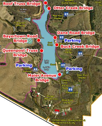
This webpage and narrative you are currently viewing is for one of the seven historic bridges that have been relocated to F. W. Kent Park on the Rod Dunlap Memorial Bridge Trail. This page provides a discussion of the individual bridge. Please also view the Dane Road Bridge page which includes a general overview discussion of F. W. Kent Park on the Rod Dunlap Memorial Bridge Trail. The map on this page shows F. W. Kent Park with all seven bridges labeled. You can click on the name of a bridge to switch to a particular bridge's page. Visit the official page for the park here. If you want to view an enlarged version of the bridge map to the left, click here.
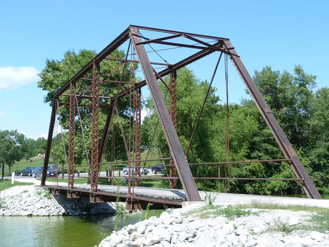
This bridge was first erected in 1902 over Old Man's Creek near Iowa City on Maier Avenue. The bridge was reportedly relocated to the park in 2003, however the abutments the bridge sits on have 1996 carved into them, suggesting either this date is incorrect or that the abutments were built many years before the bridge was moved here.
The truss bridge was reported to be built by the Pratt Bridge Company. The unusual name which does not appear to be associated with the inventors of the Pratt truss (Thomas and Caleb Pratt). The company does not appear to have been very large or prolific. The only information found during online research was that The Pratt Bridge Company was based out of Coffeyville, Kansas and established a branch of its works at Denver, Colorado in 1887.
This is the only through truss in the park. The bridge is described on park signage as a high truss bridge. This term is a less common term that means the same thing as "through truss." Similarly, pony truss bridges were sometimes called "low" truss bridges. The bridge is a good representative example of a pin-connected through truss. It is traditionally composed and features an a-frame portal bracing.
When it was relocated to the park, the bridge was made more narrow. When pony truss bridges are made more narrow, depending on the extent, it may not have a major visual effect. However, with a through truss making the bridge more narrow requires a complete reconfiguration and alteration of all overhead bracing on the bridge. Because this bracing's arrangement has been changed, it can substantially change the appearance of the bridge. As such, this bridge will have an unusual appearance to anyone familiar with viewing pin-connected highway truss bridges. In general, HistoricBridges.org recommends avoiding making through truss bridges more narrow for these reasons if it is reasonable to avoid doing so. Apparently one of the reasons for making this particular bridge more narrow was to make it lighter, and allow for its unusual form of transportation to the park. The narrowed truss was brought to the park in a pre-assembled condition by way of Chinook Helicopter which flew the bridge into the park and onto its abutments. The helicopter service was provided by the Iowa National Guard's Company F 106 Aviation Unit.
![]()
![]()
![]()
Coordinates (Latitude, Longitude):
Search For Additional Bridge Listings:
Bridgehunter.com: View listed bridges within 0.5 miles (0.8 kilometers) of this bridge.
Bridgehunter.com: View listed bridges within 10 miles (16 kilometers) of this bridge.
Additional Maps:
Google Streetview (If Available)
GeoHack (Additional Links and Coordinates)
Apple Maps (Via DuckDuckGo Search)
Apple Maps (Apple devices only)
Android: Open Location In Your Map or GPS App
Flickr Gallery (Find Nearby Photos)
Wikimedia Commons (Find Nearby Photos)
Directions Via Sygic For Android
Directions Via Sygic For iOS and Android Dolphin Browser
USGS National Map (United States Only)
Historical USGS Topo Maps (United States Only)
Historic Aerials (United States Only)
CalTopo Maps (United States Only)

© Copyright 2003-2024, HistoricBridges.org. All Rights Reserved. Disclaimer: HistoricBridges.org is a volunteer group of private citizens. HistoricBridges.org is NOT a government agency, does not represent or work with any governmental agencies, nor is it in any way associated with any government agency or any non-profit organization. While we strive for accuracy in our factual content, HistoricBridges.org offers no guarantee of accuracy. Information is provided "as is" without warranty of any kind, either expressed or implied. Information could include technical inaccuracies or errors of omission. Opinions and commentary are the opinions of the respective HistoricBridges.org member who made them and do not necessarily represent the views of anyone else, including any outside photographers whose images may appear on the page in which the commentary appears. HistoricBridges.org does not bear any responsibility for any consequences resulting from the use of this or any other HistoricBridges.org information. Owners and users of bridges have the responsibility of correctly following all applicable laws, rules, and regulations, regardless of any HistoricBridges.org information.
![]()