

View Information About HSR Ratings
 This bridge was originally located over Otter Creek in the
town of Elgin, Iowa. It was relocated to its current location in 1926. As a
result, this bridge is sometimes called the Old Elgin Creamery Bridge, in
addition to the above listed names.
This bridge was originally located over Otter Creek in the
town of Elgin, Iowa. It was relocated to its current location in 1926. As a
result, this bridge is sometimes called the Old Elgin Creamery Bridge, in
addition to the above listed names.
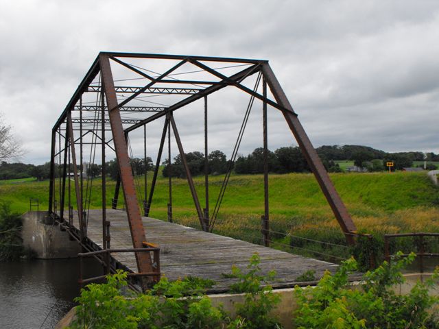
The bridge is an extremely rare example of a pin-connected Warren truss bridge. The Pratt was the far more common truss configuration used in trapezoidal truss bridges with pinned connections. The Warren only took off as a popular truss form when riveted connections became common in the early 20th century.
This bridge has been bypassed by a modern bridge, and the historic bridge was left abandoned for its aesthetic and historic value. While floods have washed away the soil around the abutments, the truss itself remains with good historic and structural integrity.
The Chicago Bridge and Iron Company was organized by a number of people including Horace E. Horton. He was president of the company in 1897 when he bought the entire company out and reorganized it as the Chicago Bridge and Iron Works, a company which remains in business today.

Information and Findings From Iowa's Historic Bridge InventoryDiscussion of Bridge This single-span truss crosses the Turkey River at
the northern edge of Fayette County, in Section 3 of Auburn Township.
Known locally as the Mill Race Bridge, presumably for its proximity to a
riverside mill, the structure is configured as a six-panel Warren truss
with pinned connections. The existing concrete abutments are evidently
replacements of an earlier substructure. Although county records are
somewhat sketchy, the Mill Race Bridge appears to have been erected n
1890. In January of that year the county board of supervisors received a
citizens' petition for a permanent bridge at this location. The petition
was referred, along with six others, to a committee of the whole, after
which a contract was awarded to build the bridge. Fayette County had
dealt almost exclusively with Horace E. Horton, a brilliant civil
engineer from Minneapolis, for its wagon bridges in the 1880s. When
Horton moved to the Chicago Bridge and Iron Company in the late 1880s,
he brought the county with him as a client, and the latter firm was
largely responsible for the county's bridges in the 1890s. The Mill Race
Bridge was probably fabricated and erected by Chicago B&I for the county
in 1890. Other than the subsequent replacement of its substructure, it
remains in essentially unaltered condition today. Bridge Considered Historic By Survey: Yes |
![]()
![]()
![]()
Coordinates (Latitude, Longitude):
Search For Additional Bridge Listings:
Bridgehunter.com: View listed bridges within 0.5 miles (0.8 kilometers) of this bridge.
Bridgehunter.com: View listed bridges within 10 miles (16 kilometers) of this bridge.
Additional Maps:
Google Streetview (If Available)
GeoHack (Additional Links and Coordinates)
Apple Maps (Via DuckDuckGo Search)
Apple Maps (Apple devices only)
Android: Open Location In Your Map or GPS App
Flickr Gallery (Find Nearby Photos)
Wikimedia Commons (Find Nearby Photos)
Directions Via Sygic For Android
Directions Via Sygic For iOS and Android Dolphin Browser
USGS National Map (United States Only)
Historical USGS Topo Maps (United States Only)
Historic Aerials (United States Only)
CalTopo Maps (United States Only)

© Copyright 2003-2024, HistoricBridges.org. All Rights Reserved. Disclaimer: HistoricBridges.org is a volunteer group of private citizens. HistoricBridges.org is NOT a government agency, does not represent or work with any governmental agencies, nor is it in any way associated with any government agency or any non-profit organization. While we strive for accuracy in our factual content, HistoricBridges.org offers no guarantee of accuracy. Information is provided "as is" without warranty of any kind, either expressed or implied. Information could include technical inaccuracies or errors of omission. Opinions and commentary are the opinions of the respective HistoricBridges.org member who made them and do not necessarily represent the views of anyone else, including any outside photographers whose images may appear on the page in which the commentary appears. HistoricBridges.org does not bear any responsibility for any consequences resulting from the use of this or any other HistoricBridges.org information. Owners and users of bridges have the responsibility of correctly following all applicable laws, rules, and regulations, regardless of any HistoricBridges.org information.
![]()