

View Information About HSR Ratings
2021 Update: This bridge is to be adaptively reused in a rather unique way with a trail but also an event area right on the bridge deck. Official Website: https://rockislandkc.com/ and also see this article: https://www.enr.com/articles/52307-developer-plans-to-transform-abandoned-kansas-city-rail-bridge-into-a-destination

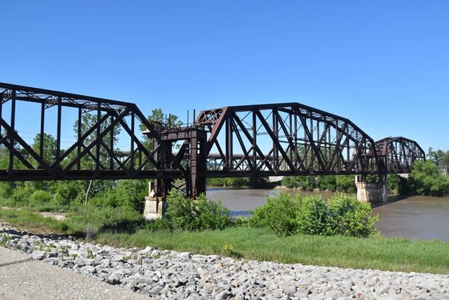
This bridge was abandoned when nearby Kemper Arena was constructed. Approach spans have been removed leaving only the truss spans. Perhaps the original approach spans extended across the state line into Missouri, but today the bridge is entirely within the borders of Kansas. This bridge is one of several bridges in Kansas City with a unique alteration: a special lift jacking system that allowed the truss spans to be raised a small amount to provide clearance during flood events. With this bridge, it appears the bridge was jacked up permanantly and new supports were added. The jacking towers and system remains in place on this bridge, and is a screw jack system, and was never replaced with a hydraulic system as was the case with some other bridges in the city.
This bridge would be a great candidate for reuse as a pedestrian crossing.

Above: Abandoned machinery remains for the screw jack lifting system.
![]()
![]()
![]()
Coordinates (Latitude, Longitude):
Search For Additional Bridge Listings:
Bridgehunter.com: View listed bridges within 0.5 miles (0.8 kilometers) of this bridge.
Bridgehunter.com: View listed bridges within 10 miles (16 kilometers) of this bridge.
Additional Maps:
Google Streetview (If Available)
GeoHack (Additional Links and Coordinates)
Apple Maps (Via DuckDuckGo Search)
Apple Maps (Apple devices only)
Android: Open Location In Your Map or GPS App
Flickr Gallery (Find Nearby Photos)
Wikimedia Commons (Find Nearby Photos)
Directions Via Sygic For Android
Directions Via Sygic For iOS and Android Dolphin Browser
USGS National Map (United States Only)
Historical USGS Topo Maps (United States Only)
Historic Aerials (United States Only)
CalTopo Maps (United States Only)

© Copyright 2003-2024, HistoricBridges.org. All Rights Reserved. Disclaimer: HistoricBridges.org is a volunteer group of private citizens. HistoricBridges.org is NOT a government agency, does not represent or work with any governmental agencies, nor is it in any way associated with any government agency or any non-profit organization. While we strive for accuracy in our factual content, HistoricBridges.org offers no guarantee of accuracy. Information is provided "as is" without warranty of any kind, either expressed or implied. Information could include technical inaccuracies or errors of omission. Opinions and commentary are the opinions of the respective HistoricBridges.org member who made them and do not necessarily represent the views of anyone else, including any outside photographers whose images may appear on the page in which the commentary appears. HistoricBridges.org does not bear any responsibility for any consequences resulting from the use of this or any other HistoricBridges.org information. Owners and users of bridges have the responsibility of correctly following all applicable laws, rules, and regulations, regardless of any HistoricBridges.org information.
![]()