

View Information About HSR Ratings

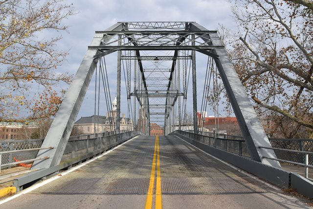
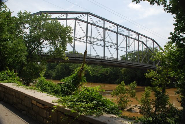
This is both a beautiful and a highly significant historic bridge. Built in 1893 and with a main span of 405 feet, this is an extremely long simple span truss bridge for its age. It represents a significant engineering achievement for its period. The King Bridge Company was a noteworthy and prolific bridge builder and the company actually built a number of fairly large simple span truss bridges that followed the Pennsylvania truss configuration. Nearly all examples of these long-span bridges built by King have been demolished. Thus, this bridge is distinguished as one of the last surviving long-span truss bridges built by King. Because of its span length, this bridge has a very tall and impressive appearance to it. Yet, as an 19th Century pin-connected truss bridge, it also has the lightweight, delicate appearance associated with that type of bridge. It is a visually pleasing bridge. Fortunately, this bridge has been preserved for vehicular use. It was rehabilitated in 1956 and in 2010.
This bridge originally had a large plaque on its portal, as well as ornamental portal cresting and finials. It also had a beautiful gothic arch lattice railing. All of these have been lost over the years.

![]()
![]()
![]()
![]()
![]()
Coordinates (Latitude, Longitude):
Search For Additional Bridge Listings:
Bridgehunter.com: View listed bridges within 0.5 miles (0.8 kilometers) of this bridge.
Bridgehunter.com: View listed bridges within 10 miles (16 kilometers) of this bridge.
Additional Maps:
Google Streetview (If Available)
GeoHack (Additional Links and Coordinates)
Apple Maps (Via DuckDuckGo Search)
Apple Maps (Apple devices only)
Android: Open Location In Your Map or GPS App
Flickr Gallery (Find Nearby Photos)
Wikimedia Commons (Find Nearby Photos)
Directions Via Sygic For Android
Directions Via Sygic For iOS and Android Dolphin Browser
USGS National Map (United States Only)
Historical USGS Topo Maps (United States Only)
Historic Aerials (United States Only)
CalTopo Maps (United States Only)

© Copyright 2003-2024, HistoricBridges.org. All Rights Reserved. Disclaimer: HistoricBridges.org is a volunteer group of private citizens. HistoricBridges.org is NOT a government agency, does not represent or work with any governmental agencies, nor is it in any way associated with any government agency or any non-profit organization. While we strive for accuracy in our factual content, HistoricBridges.org offers no guarantee of accuracy. Information is provided "as is" without warranty of any kind, either expressed or implied. Information could include technical inaccuracies or errors of omission. Opinions and commentary are the opinions of the respective HistoricBridges.org member who made them and do not necessarily represent the views of anyone else, including any outside photographers whose images may appear on the page in which the commentary appears. HistoricBridges.org does not bear any responsibility for any consequences resulting from the use of this or any other HistoricBridges.org information. Owners and users of bridges have the responsibility of correctly following all applicable laws, rules, and regulations, regardless of any HistoricBridges.org information.
![]()