

View Information About HSR Ratings
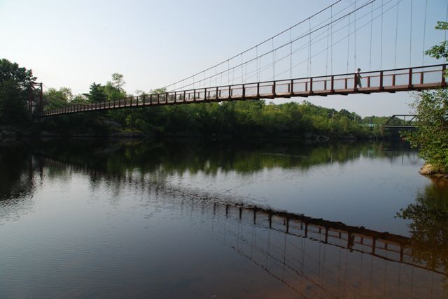
This is an impressive suspension foot bridge. Like many such structures, this bridge is known as a "swinging bridge," a name that many suspension foot bridges take on because they are not designed to be as stiff as a vehicular suspension bridge and they often move noticeably under the weight of people walking on them.
This bridge has a colorful history that comes at the cost of historic integrity. To say this is an altered bridge is an understatement. The construction date is listed as 1892, and this is when the bridge was first built. Its purpose was to let people who lives in Topsham to get to Cabot Mill in Brunswick. The original bridge had timber towers. In the early 1900s, the timber towers were demolished with riveted steel towers. In 1936, a flood destroyed the stiffening system and deck of the bridge, but left the 1892 cables and the early 1900s tower intact. A new deck and stiffening system was installed using federal Depression era relief funds. Finally, in 2007, miscellaneous rehabilitation of the bridge was undertaken. According to the Brunswick Downtown Association, the cables on the bridge are the original 1892 cables. Assuming this is true, the has three different construction dates for major parts of the bridge.
![]()
![]()
![]()
Coordinates (Latitude, Longitude):
Search For Additional Bridge Listings:
Bridgehunter.com: View listed bridges within 0.5 miles (0.8 kilometers) of this bridge.
Bridgehunter.com: View listed bridges within 10 miles (16 kilometers) of this bridge.
Additional Maps:
Google Streetview (If Available)
GeoHack (Additional Links and Coordinates)
Apple Maps (Via DuckDuckGo Search)
Apple Maps (Apple devices only)
Android: Open Location In Your Map or GPS App
Flickr Gallery (Find Nearby Photos)
Wikimedia Commons (Find Nearby Photos)
Directions Via Sygic For Android
Directions Via Sygic For iOS and Android Dolphin Browser
USGS National Map (United States Only)
Historical USGS Topo Maps (United States Only)
Historic Aerials (United States Only)
CalTopo Maps (United States Only)

© Copyright 2003-2024, HistoricBridges.org. All Rights Reserved. Disclaimer: HistoricBridges.org is a volunteer group of private citizens. HistoricBridges.org is NOT a government agency, does not represent or work with any governmental agencies, nor is it in any way associated with any government agency or any non-profit organization. While we strive for accuracy in our factual content, HistoricBridges.org offers no guarantee of accuracy. Information is provided "as is" without warranty of any kind, either expressed or implied. Information could include technical inaccuracies or errors of omission. Opinions and commentary are the opinions of the respective HistoricBridges.org member who made them and do not necessarily represent the views of anyone else, including any outside photographers whose images may appear on the page in which the commentary appears. HistoricBridges.org does not bear any responsibility for any consequences resulting from the use of this or any other HistoricBridges.org information. Owners and users of bridges have the responsibility of correctly following all applicable laws, rules, and regulations, regardless of any HistoricBridges.org information.
![]()