

View Information About HSR Ratings
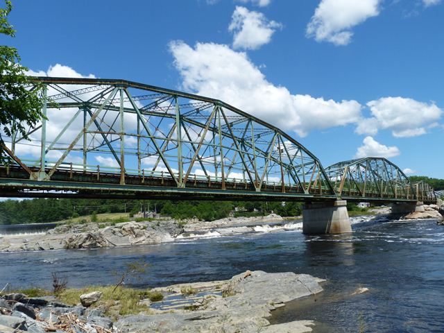
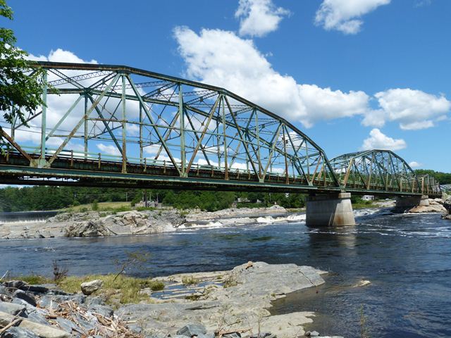
In general, this bridge is an example of a traditionally composed state-designed 1930s truss bridge in Maine. It has a large central through truss span with a single shorter through truss spans at each end. The bridge has considerable historic and technological significance. This bridge is among the larger of Maine's surviving metal truss bridges both in terms of its 310 foot central span and an overall 815 foot length. Additionally, it has the unusual design detail in that the southernmost bridge pier is skewed, however the other pier and both abutments are not skewed. As such, the only evidence of skew in the superstructure is that the southern end of the central span and the northern end of the southern span displays offset end posts. The skew is not carried through the rest of the truss like in a traditional skewed bridge. It is not known why the one pier is skewed except that is may be so that it lines up with the flow of the water in the river, to reduce pressure on the pier from flowing water. The northern pier rests on exposed rock and does not appear to be in the water normally, so this would explain why it is not skewed.
When HistoricBridges.org visited this bridge it was found to be extremely busy with nearly non-stop traffic on it.
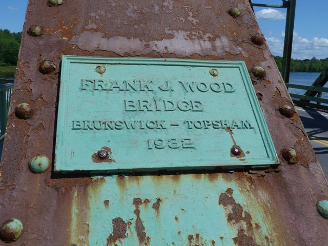
Information and Findings From Maine's Historic Bridge InventoryDiscussion of Bridge The 1932, riveted, Warren thru truss is not individually significant. It is a later example of a common bridge type, and it has no innovative or distinctive details. It is, however, located in a National Register-eligible textile mill historic district in Brunswick-Topsham. Since the bridge is located within the historic district, was built within its period of significance, and is complete, it is a contributing resource to the industrial historic district. The bridge carried a street railway at one time. The bridge is judged to have average preservation priority because an example of a common bridge type and is located in a non-transportation related historic district. Bridge Considered Historic By Survey: Yes |
![]()
![]()
![]()
![]()
![]()
Coordinates (Latitude, Longitude):
Search For Additional Bridge Listings:
Bridgehunter.com: View listed bridges within 0.5 miles (0.8 kilometers) of this bridge.
Bridgehunter.com: View listed bridges within 10 miles (16 kilometers) of this bridge.
Additional Maps:
Google Streetview (If Available)
GeoHack (Additional Links and Coordinates)
Apple Maps (Via DuckDuckGo Search)
Apple Maps (Apple devices only)
Android: Open Location In Your Map or GPS App
Flickr Gallery (Find Nearby Photos)
Wikimedia Commons (Find Nearby Photos)
Directions Via Sygic For Android
Directions Via Sygic For iOS and Android Dolphin Browser
USGS National Map (United States Only)
Historical USGS Topo Maps (United States Only)
Historic Aerials (United States Only)
CalTopo Maps (United States Only)

© Copyright 2003-2024, HistoricBridges.org. All Rights Reserved. Disclaimer: HistoricBridges.org is a volunteer group of private citizens. HistoricBridges.org is NOT a government agency, does not represent or work with any governmental agencies, nor is it in any way associated with any government agency or any non-profit organization. While we strive for accuracy in our factual content, HistoricBridges.org offers no guarantee of accuracy. Information is provided "as is" without warranty of any kind, either expressed or implied. Information could include technical inaccuracies or errors of omission. Opinions and commentary are the opinions of the respective HistoricBridges.org member who made them and do not necessarily represent the views of anyone else, including any outside photographers whose images may appear on the page in which the commentary appears. HistoricBridges.org does not bear any responsibility for any consequences resulting from the use of this or any other HistoricBridges.org information. Owners and users of bridges have the responsibility of correctly following all applicable laws, rules, and regulations, regardless of any HistoricBridges.org information.
![]()