

View Information About HSR Ratings
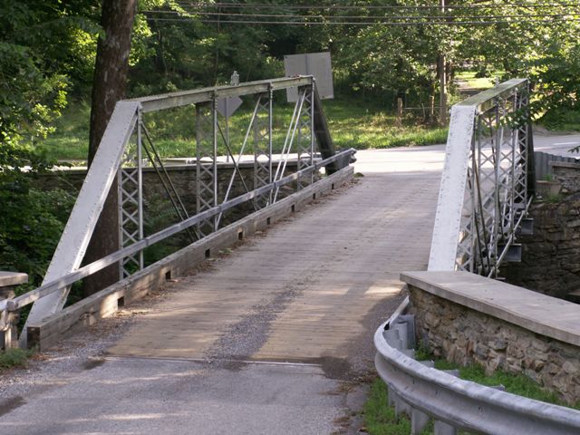
This bridge is a small pony truss with a special attraction, which is the top-chord-mounted builder plaque. Groton Bridge Company was the builder, and this company was noted for doing this on its pony truss bridges. The plaque stands out and is more decorative in this fashion.
As the road's name suggests, this is a rocky area. The bridge sits on stone abutments, but part of one of the abutments is actually a natural and undisturbed rock outcropping upon which the bridge was placed, adding to the interest of the bridge. For all the criticism historians give the period in which this bridge was built for polluting and destroying the environment, bridge erection itself in this period was often done in harmony with nature. Bridges were often built to cross the river at the easiest or shortest point, and bridges might have an odd angle to the approaching roadway to meet this goal. Natural materials might be used, whether cementing rubble together to form an abutment, or as in the case of this bridge, using a natural rock outcropping for the abutment. Today, if the bridge was replaced, engineers and contractors would blast all this natural rock apart, tear out all the trees and half the river bank, and build a big concrete abutment.
However, Frederick Count instead rehabilitated this bridge, setting an example for other locations to follow. While some integrity was lost, notably in the replacement of floorbeams, the trusses retain integrity and the overall appearance of the structure remains historic and attractive.
![]()
![]()
![]()
Coordinates (Latitude, Longitude):
Search For Additional Bridge Listings:
Bridgehunter.com: View listed bridges within 0.5 miles (0.8 kilometers) of this bridge.
Bridgehunter.com: View listed bridges within 10 miles (16 kilometers) of this bridge.
Additional Maps:
Google Streetview (If Available)
GeoHack (Additional Links and Coordinates)
Apple Maps (Via DuckDuckGo Search)
Apple Maps (Apple devices only)
Android: Open Location In Your Map or GPS App
Flickr Gallery (Find Nearby Photos)
Wikimedia Commons (Find Nearby Photos)
Directions Via Sygic For Android
Directions Via Sygic For iOS and Android Dolphin Browser
USGS National Map (United States Only)
Historical USGS Topo Maps (United States Only)
Historic Aerials (United States Only)
CalTopo Maps (United States Only)

© Copyright 2003-2024, HistoricBridges.org. All Rights Reserved. Disclaimer: HistoricBridges.org is a volunteer group of private citizens. HistoricBridges.org is NOT a government agency, does not represent or work with any governmental agencies, nor is it in any way associated with any government agency or any non-profit organization. While we strive for accuracy in our factual content, HistoricBridges.org offers no guarantee of accuracy. Information is provided "as is" without warranty of any kind, either expressed or implied. Information could include technical inaccuracies or errors of omission. Opinions and commentary are the opinions of the respective HistoricBridges.org member who made them and do not necessarily represent the views of anyone else, including any outside photographers whose images may appear on the page in which the commentary appears. HistoricBridges.org does not bear any responsibility for any consequences resulting from the use of this or any other HistoricBridges.org information. Owners and users of bridges have the responsibility of correctly following all applicable laws, rules, and regulations, regardless of any HistoricBridges.org information.
![]()