

View Information About HSR Ratings
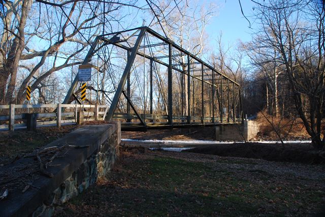
This is a well-preserved and relatively long span example of a pin-connected Pratt truss highway bridge.
The Historic Bridge Inventory listed an 1883 construction date for this bridge. The bridge has a modern plaque on it which was added in recent times and is not an original. The plaque has an 1883 date on it. The plaque is clearly designed to resemble this bridge's original plaque. However, the plaque design was only used by the Wrought Iron Bridge Company in the 1890s. This bridge's a-frame portal bracing is a design detail that the Wrought Iron Bridge Company did not start using until ca. 1889-1890. It is the strong opinion of HistoricBridges.org that this bridge was not built in 1883. It does not look like any Wrought Iron Bridge Company bridge built in the early 1880s, yet it follows the design of many 1890s Wrought Iron Bridge Company bridges in precise detail. It is not known how 1883 got associated with this bridge. Perhaps old/unclear historical photos of this bridge had a photo of the plaque and a "9" was mistaken for an "8." Also of interest, despite the 1883 plaque on the bridge, the National Bridge Inventory lists an 1890 construction date for the bridge. Either 1893 and 1890 would make a lot more sense for this bridge.
None of this changes the fact that this is an outstanding example of a Wrought Iron Bridge Company Pratt truss bridge, and thus whatever the construction date of the bridge, this is a beautiful historic bridge.
![]()
![]()
![]()
Coordinates (Latitude, Longitude):
Search For Additional Bridge Listings:
Bridgehunter.com: View listed bridges within 0.5 miles (0.8 kilometers) of this bridge.
Bridgehunter.com: View listed bridges within 10 miles (16 kilometers) of this bridge.
Additional Maps:
Google Streetview (If Available)
GeoHack (Additional Links and Coordinates)
Apple Maps (Via DuckDuckGo Search)
Apple Maps (Apple devices only)
Android: Open Location In Your Map or GPS App
Flickr Gallery (Find Nearby Photos)
Wikimedia Commons (Find Nearby Photos)
Directions Via Sygic For Android
Directions Via Sygic For iOS and Android Dolphin Browser
USGS National Map (United States Only)
Historical USGS Topo Maps (United States Only)
Historic Aerials (United States Only)
CalTopo Maps (United States Only)

© Copyright 2003-2024, HistoricBridges.org. All Rights Reserved. Disclaimer: HistoricBridges.org is a volunteer group of private citizens. HistoricBridges.org is NOT a government agency, does not represent or work with any governmental agencies, nor is it in any way associated with any government agency or any non-profit organization. While we strive for accuracy in our factual content, HistoricBridges.org offers no guarantee of accuracy. Information is provided "as is" without warranty of any kind, either expressed or implied. Information could include technical inaccuracies or errors of omission. Opinions and commentary are the opinions of the respective HistoricBridges.org member who made them and do not necessarily represent the views of anyone else, including any outside photographers whose images may appear on the page in which the commentary appears. HistoricBridges.org does not bear any responsibility for any consequences resulting from the use of this or any other HistoricBridges.org information. Owners and users of bridges have the responsibility of correctly following all applicable laws, rules, and regulations, regardless of any HistoricBridges.org information.
![]()