

View Information About HSR Ratings
Location:
Phoenix, Baltimore County, Maryland. A few miles east of
Interstate 83, about 15 miles north of Baltimore and 20 miles south of the
Maryland/Pennsylvania state line.
Setting:
Rural, crosses reservoir surrounded by wooded hills.
Access:
Shawan
Road/Hunt Valley exit from I-83. No parking available, and there is limited
ability to park on the shoulder of Paper Mill Road, which has fairly heavy
traffic. Even if you can pull over and risk the traffic to get to the end of the
bridge, you cannot walk onto it.
Crosses:
Loch Raven Reservoir
Current Status:
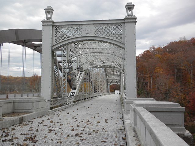
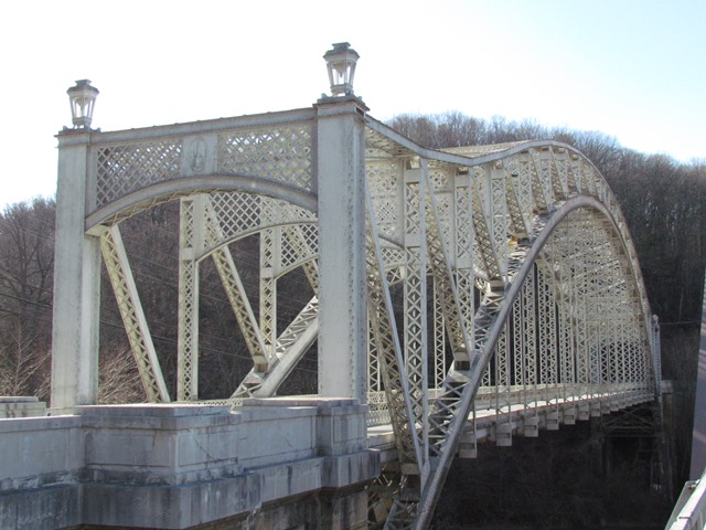
Closed to traffic. It formerly was a one-lane bridge, steel
grid deck, carrying traffic on Paper Mill Road, a narrow, winding two-lane road.
Although you can walk up to the western end of the bridge, you cannot walk onto
or around it, which is a shame, because it is gorgeous. The ends are blocked by
steel grates. Also, there is no parking available, and the bridge is not on any
trails. Given this lack of access, the presence of historical exhibit panels at
the western end of the bridge is interesting, since it is not clear how people
are supposed to get there to see them. There is construction equipment present,
and it is possible that work is being done to connect the bridge to trails, and
it will be accessible in the future. However, there are no nearby trails, and
the shoulder of the road is too narrow to safely access by foot or bicycle.
A new bridge was built right next to it (within 25 feet) in 2001, and the
old bridge was rehabilitated in 2007.
Decorations/Plaques:
Plaque on
truss over roadway is the Seal of the City of Baltimore, which built and owns
the bridge. Interestingly, the bridge is not within the city limits, but crosses
a reservoir built and owned by the city. The seal lists the date of 1797, which
is the date for the founding of the City of Baltimore, not the date for the
bridge. The bridge itself has no date plaque, but the historical exhibit panel
installed at the western end of the bridge provides the date, as well as some
construction information. The end truss of the bridge is beautifully decorated
with a diagonal steel lattice, and the vertical girders on the sides of the end
truss are capped with lovely lanterns.
Threats:
Threats are unlikely,
since the bridge was bypassed in 2001, and then rehabilitated for preservation
purposes in 2007. However, even though the bridge has been preserved, no attempt
has been made to make it accessible. The ends are blocked by unattractive
grates, there is no parking available, and there are no hiking or bike trails
that go over it. There is currently construction equipment staged at one end of
the bridge. This may be staged only because it is a convenient place for a local
project, but it is possible that work is going to be undertaken to make the
bridge accessible.
This unique bridge was designed by Hershel Hethcote Allen of the J. E. Greiner Company. J. E. stands for John Edwin Greiner, a well-known bridge engineer. This bridge is noted for its ornamental portal bracing and rare through arch design. It has been bypassed and abandoned, but was rehabilitated before abandonment, so it remains in great condition and is a historic landmark. A similarly ornamented bridge, but with a truss design, remains open to traffic on Warren Road.
Even though it isn't in the city of Baltimore, the city is noted on the portal bracing because this bridge was built as part of the reservoir created for the city.
This bridge is tagged with the following special condition(s): Unorganized Photos
![]()
![]()
![]()
![]()
![]()
Coordinates (Latitude, Longitude):
Search For Additional Bridge Listings:
Bridgehunter.com: View listed bridges within 0.5 miles (0.8 kilometers) of this bridge.
Bridgehunter.com: View listed bridges within 10 miles (16 kilometers) of this bridge.
Additional Maps:
Google Streetview (If Available)
GeoHack (Additional Links and Coordinates)
Apple Maps (Via DuckDuckGo Search)
Apple Maps (Apple devices only)
Android: Open Location In Your Map or GPS App
Flickr Gallery (Find Nearby Photos)
Wikimedia Commons (Find Nearby Photos)
Directions Via Sygic For Android
Directions Via Sygic For iOS and Android Dolphin Browser
USGS National Map (United States Only)
Historical USGS Topo Maps (United States Only)
Historic Aerials (United States Only)
CalTopo Maps (United States Only)

© Copyright 2003-2024, HistoricBridges.org. All Rights Reserved. Disclaimer: HistoricBridges.org is a volunteer group of private citizens. HistoricBridges.org is NOT a government agency, does not represent or work with any governmental agencies, nor is it in any way associated with any government agency or any non-profit organization. While we strive for accuracy in our factual content, HistoricBridges.org offers no guarantee of accuracy. Information is provided "as is" without warranty of any kind, either expressed or implied. Information could include technical inaccuracies or errors of omission. Opinions and commentary are the opinions of the respective HistoricBridges.org member who made them and do not necessarily represent the views of anyone else, including any outside photographers whose images may appear on the page in which the commentary appears. HistoricBridges.org does not bear any responsibility for any consequences resulting from the use of this or any other HistoricBridges.org information. Owners and users of bridges have the responsibility of correctly following all applicable laws, rules, and regulations, regardless of any HistoricBridges.org information.
![]()