

View Information About HSR Ratings

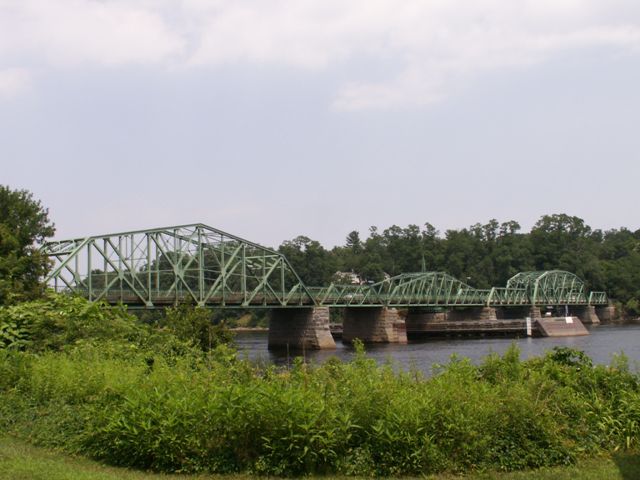
This bridge is an extremely important and extremely bizarre bridge. Nearly every span is a unique form of truss bridge, and the spans were built over three different dates. As such, this bridge has a unique and striking appearance.
From west to east, the spans on this bridge are as follows. A riveted Pennsylvania through truss, built in 1895. A riveted, double-intersection Warren pony truss, built in 1883. A through truss swing span built in 1883. A riveted Pratt pony truss, built in 1914. A riveted Pennsylvania through truss, built in 1914. A riveted Pratt pony truss, built in 1914. As such, there are a total of five unique spans on this bridge. The only identical spans are the riveted Pratt pony spans.
The western 1895 Pennsylvania through truss is very unusual because its polygonal top chord only features four slopes including endposts. It is in effect, in between being a standard trapezoidal truss and a Camelback. The swing span is an extremely old surviving example of a highway swing bridge, which the oldest known example in the entire country dating to 1879.
The 1883 swing span and the double-intersection Warren pony truss spas are the oldest examples of a highway truss with riveted connections in the state. Indeed, they may be among the oldest examples of this kind in the entire country. 1883 was early in the pin-connected truss era, and riveted connections did not become common, especially in highway bridges, until after 1900. The 1883 swing span is also the oldest known example of the Boston Bridge Works, an important Massachusetts bridge company that was extremely prolific, especially in its home state.
Information and Findings From Massachusetts's Historic Bridge InventoryStructure Description Date Built: 1883, 1895, 1914 Structure Type Span 1: riveted Pennsylvania through truss, built
1895. Span 2: riveted, 2 intersection Warren pony truss, built 1883.
Span 3: Rim-bearing, swing, through truss built in 1883. Span 4: riveted
Pratt pony truss, built in 1914. Span 5: riveted Pennsylvania through
truss, built in 1914. Span 6: riveted Pratt pony truss, built in 1914. History of Bridge Seat's Ferry was in operation on or near this crossing in the early 18th century; in 1794 the Massachusetts Legislature incorporated the Merrimack Bridge proprietors and approved construction of a bridge on this site. This was apparently built within the next year. The original bridge had been destroyed by 1828 when the legislature approved construction of a new bridge on the old foundations, to be 22 feet above high water at the Haverhill end. In 1862 the County commissioners were authorized to relocate and reconstruct the draw (implying that a drawspan of some kind has previously been in use here) and the present iron spans 2 & 3 were the result (the bridge had been made public in 1868). The County Commissioners were authorized to build a new iron westerly span and new abutments in 1894; the result is the structure of span 1. From 1868-1909, the towns of Haverhill & W. Newbury split the maintenance on the bride; in 1909 the County assumed full responsibility. The Legislature approved construction of the 3 eastern steel truss spans (spans 4, 5, and 6) to replace the two old wooden spans between the draw span and the West Newbury shore in 1913. Significance of Bridge The Rocks Village Bridge contains the oldest movable
span among all the bridges presently under MassHighway purview. It is
located adjacent to the Rocks Village National Register Historic
District, on a site which has been utilized as a major Merrimack River
crossing since at least as the early 18th century. Bridge Considered Historic By Survey: Yes |
![]()
![]()
![]()
Coordinates (Latitude, Longitude):
Search For Additional Bridge Listings:
Bridgehunter.com: View listed bridges within 0.5 miles (0.8 kilometers) of this bridge.
Bridgehunter.com: View listed bridges within 10 miles (16 kilometers) of this bridge.
Additional Maps:
Google Streetview (If Available)
GeoHack (Additional Links and Coordinates)
Apple Maps (Via DuckDuckGo Search)
Apple Maps (Apple devices only)
Android: Open Location In Your Map or GPS App
Flickr Gallery (Find Nearby Photos)
Wikimedia Commons (Find Nearby Photos)
Directions Via Sygic For Android
Directions Via Sygic For iOS and Android Dolphin Browser
USGS National Map (United States Only)
Historical USGS Topo Maps (United States Only)
Historic Aerials (United States Only)
CalTopo Maps (United States Only)

© Copyright 2003-2024, HistoricBridges.org. All Rights Reserved. Disclaimer: HistoricBridges.org is a volunteer group of private citizens. HistoricBridges.org is NOT a government agency, does not represent or work with any governmental agencies, nor is it in any way associated with any government agency or any non-profit organization. While we strive for accuracy in our factual content, HistoricBridges.org offers no guarantee of accuracy. Information is provided "as is" without warranty of any kind, either expressed or implied. Information could include technical inaccuracies or errors of omission. Opinions and commentary are the opinions of the respective HistoricBridges.org member who made them and do not necessarily represent the views of anyone else, including any outside photographers whose images may appear on the page in which the commentary appears. HistoricBridges.org does not bear any responsibility for any consequences resulting from the use of this or any other HistoricBridges.org information. Owners and users of bridges have the responsibility of correctly following all applicable laws, rules, and regulations, regardless of any HistoricBridges.org information.
![]()