

View Information About HSR Ratings
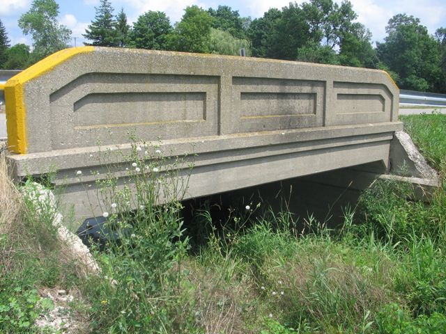
This single bridge page has photos for three tiny bridges that are absolutely identical in design and size. They are located a short distance from each other on Ball Creek Road and they all cross Ball Creek which weaves back and forth under the road. They all retain excellent historic integrity and they document their type well. They are identified on HistoricBridges.org as the Western Bridge, the Central Bridge, and the Eastern Bridge.
Tiny structures like these three bridges still occasionally dot Michigan's landscape in many places. It is the unique railing design that identifies these bridges which were built in the 1920s and 1930s for very short single span crossings. Most of these bridges tend to be shorter than these three bridges and are often under 20 feet long. For the longest examples which may exceed 20 feet by a few additional feet, a slightly different architectural detailing was used on the railings, but the overall design of the railing remains the same. Examples of the shorter designs can be seen on Fisher Road in St. Clair County. The smaller examples are much more numerous in Michigan today. The larger examples like these three bridges crossing Ball Creek are more uncommon. The shorter bridges are usually reinforced concrete slab bridges, while the larger bridges like the Ball Creek Road Bridges are concrete t-beam bridges.
Randy Mulder provided some additional history about the bridges and the roadway these bridges serve:
These 3 identical bridges are located within a mile of each other on a road named after the creek they cross. According to www.michiganhighways.org, the original state trunk line from Grand Rapids to Baldwin was called M-54, and "stair-stepped" at right angles through towns NW of Grand Rapids to past the county line, as seen on a 1926 map. Michiganhighways.org says that the designation changed to M-37 by 1928, and that the route was not straightened through Kent City and Casnovia until 1930, which would be the present-day Ball Creek Road, the site of these bridges. However, this supposedly 1927 map seems to already show named-highway M-37 with the angled Ball Creek Road alignment. This seems more reasonable, since the bridges had already been built in 1925, apparently as part of a trunkline project. The route could even have been in place before the 1926 map, possibly not fully updated, was published. A new routing of M-37 completely bypassed Sparta, Kent City, and Casnovia in 1962. Interestingly, the south several miles were built as a 4-lane divided limited access road, and today even the 2-lane portion to the north is limited access with extra-wide right-of-way (for future expansion which never came) up to where it rejoins the old route at Apple Ave west of Casnovia. Anyway, this left Ball Creek Road as a lightly-travelled route, which is probably why these bridges are still with us.
There is also an essentially identical bridge, built the same year as the 3 Kent City bridges, located just a few miles north that carries Tyrone Avenue over Walter Creek Drain, built in 1925. Since Tyrone Ave. has probably never been a main route, someone may have taken this construction opportunity to get a decent bridge at an otherwise undistinguished crossing. This bridge has no other railings, probably because it is close to a stop sign in a relatively remote area.
![]()
![]()
![]()
The maps shown here are for the central bridge. The coordinates for the western bridge are 43.221667, -85.760556 and the eastern bridge is at 43.216111, -85.748889
Coordinates (Latitude, Longitude):
Search For Additional Bridge Listings:
Bridgehunter.com: View listed bridges within 0.5 miles (0.8 kilometers) of this bridge.
Bridgehunter.com: View listed bridges within 10 miles (16 kilometers) of this bridge.
Additional Maps:
Google Streetview (If Available)
GeoHack (Additional Links and Coordinates)
Apple Maps (Via DuckDuckGo Search)
Apple Maps (Apple devices only)
Android: Open Location In Your Map or GPS App
Flickr Gallery (Find Nearby Photos)
Wikimedia Commons (Find Nearby Photos)
Directions Via Sygic For Android
Directions Via Sygic For iOS and Android Dolphin Browser
USGS National Map (United States Only)
Historical USGS Topo Maps (United States Only)
Historic Aerials (United States Only)
CalTopo Maps (United States Only)

© Copyright 2003-2024, HistoricBridges.org. All Rights Reserved. Disclaimer: HistoricBridges.org is a volunteer group of private citizens. HistoricBridges.org is NOT a government agency, does not represent or work with any governmental agencies, nor is it in any way associated with any government agency or any non-profit organization. While we strive for accuracy in our factual content, HistoricBridges.org offers no guarantee of accuracy. Information is provided "as is" without warranty of any kind, either expressed or implied. Information could include technical inaccuracies or errors of omission. Opinions and commentary are the opinions of the respective HistoricBridges.org member who made them and do not necessarily represent the views of anyone else, including any outside photographers whose images may appear on the page in which the commentary appears. HistoricBridges.org does not bear any responsibility for any consequences resulting from the use of this or any other HistoricBridges.org information. Owners and users of bridges have the responsibility of correctly following all applicable laws, rules, and regulations, regardless of any HistoricBridges.org information.
![]()