

View Information About HSR Ratings
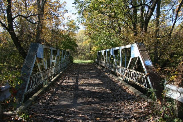
This bridge has a 1950 construction date listed, which seems too new and may indicate instead that the bridge was moved to this location at that date. The bridge has a deck width of a little over 10 feet, which makes it an extremely narrow bridge for its type. This implies the bridge was built for use on a low volume roadway. The bridge displays large gusset plates on the top chord connections. No v-lacing or lattice is present on the bridge, typical of a later riveted truss bridge. The bridge is located in the Middle Rouge Parkway. It still serves non-motorized traffic on an undeveloped trail.
Jack Allen provided the following ideas on the bridge's history:
The rehab date might very well refer to when the bridge was moved there. That bridge was not in its present location in the 1960s because aerial photos dated 1949, 1956, 1961 and 1967 show no bridge in that location. There was no road or trail in the 1949 aerial photo where this bridge is today. Aerial photos from 1949 through 1997 are available from Wayne State University through the courtesy of Detroit Edison (DTE). Interestingly, the old Farmington Road bridge was still in place over the Rouge River throughout the 1960s, south of the subject bridge. It was south of Edward Hines Drive and it took traffic south to Cowan Road. It was one of several old, single-lane bridges that were closed in the 60s and 70s for various reasons. The old Farmington Road bridge appears to be identical to the subject bridge. I recall that that stretch of Farmington Road was closed in the 1970s. I am guessing that the old Farmington Road bridge was moved north, across Edward N. Hines Drive, to add to the Nankin Mills museum historic attraction, thus the confusing dates of 1950 and 1977.
![]()
![]()
![]()
Coordinates (Latitude, Longitude):
Search For Additional Bridge Listings:
Bridgehunter.com: View listed bridges within 0.5 miles (0.8 kilometers) of this bridge.
Bridgehunter.com: View listed bridges within 10 miles (16 kilometers) of this bridge.
Additional Maps:
Google Streetview (If Available)
GeoHack (Additional Links and Coordinates)
Apple Maps (Via DuckDuckGo Search)
Apple Maps (Apple devices only)
Android: Open Location In Your Map or GPS App
Flickr Gallery (Find Nearby Photos)
Wikimedia Commons (Find Nearby Photos)
Directions Via Sygic For Android
Directions Via Sygic For iOS and Android Dolphin Browser
USGS National Map (United States Only)
Historical USGS Topo Maps (United States Only)
Historic Aerials (United States Only)
CalTopo Maps (United States Only)

© Copyright 2003-2024, HistoricBridges.org. All Rights Reserved. Disclaimer: HistoricBridges.org is a volunteer group of private citizens. HistoricBridges.org is NOT a government agency, does not represent or work with any governmental agencies, nor is it in any way associated with any government agency or any non-profit organization. While we strive for accuracy in our factual content, HistoricBridges.org offers no guarantee of accuracy. Information is provided "as is" without warranty of any kind, either expressed or implied. Information could include technical inaccuracies or errors of omission. Opinions and commentary are the opinions of the respective HistoricBridges.org member who made them and do not necessarily represent the views of anyone else, including any outside photographers whose images may appear on the page in which the commentary appears. HistoricBridges.org does not bear any responsibility for any consequences resulting from the use of this or any other HistoricBridges.org information. Owners and users of bridges have the responsibility of correctly following all applicable laws, rules, and regulations, regardless of any HistoricBridges.org information.
![]()