

View Information About HSR Ratings
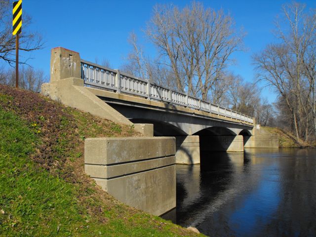
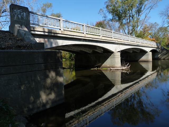
This bridge is an early example of a bridge design that was built in Michigan primarily in the 1950s and 1960s. Several of Michigan's freeways, notably I-94, I-75, and I-96 are still dotted with overpasses that follow this attractive design which combines Michigan's attractive "R-4" style railing used from the 1930s-1960s, with a graceful curved beam superstructure, forming a structure that is very pleasing to the eye. with a 1952 construction date, this bridge is among the oldest that follow that design, and moreover is also noteworthy as one of the few surviving examples crossing a waterway rather than a roadway/freeway. An example of a predecessor to the Kinneville Road Bridge might be the nearby State Street Bridge, which is essentially the same design, but has an older railing style on it. It is unclear why two bridges of similar, but uncommon design are located so near to each other (yet in different counties and jurisdictions). Perhaps it was river crossing bridges like these that served as inspiration for the later freeway structures like Sigler Road.
The Kinneville Road Bridge is also noteworthy for its extremely high degree of historic integrity. Absolutely no alterations were observed. The plaques are in place on the bridge. The railings are original with no modern railings added, and not even approach Armco guardrails are present. Even the deck is original concrete with no added asphalt wearing surface. No alterations to the beams, piers, or abutments were observed. The bridge also remains in good condition. Because of the historic and structural integrity of the bridge, this structure is a good candidate for preservation.
Information and Findings From Michigan Historic Bridge InventoryNarrative Description The Kinneville Road Bridge,
which is skewed, is positioned on an east-west axis in a rural section
of the county. Scattered homes are located near the site along the
river, which is used fro recreational purposes. Standard State Highway
Department railings, consisting of metal panels between metal posts with
raised detailing, edge the roadway, terminating at concrete end posts
with recesses on three sides. Bridge plates are displayed at the
northeast and southwest corners. The wing walls are detailed with two
incised lines near the top, identical to the bridge's pier detailing.
|
This bridge is tagged with the following special condition(s): Unorganized Photos
![]()
![]()
![]()
![]()
![]()
Coordinates (Latitude, Longitude):
Search For Additional Bridge Listings:
Bridgehunter.com: View listed bridges within 0.5 miles (0.8 kilometers) of this bridge.
Bridgehunter.com: View listed bridges within 10 miles (16 kilometers) of this bridge.
Additional Maps:
Google Streetview (If Available)
GeoHack (Additional Links and Coordinates)
Apple Maps (Via DuckDuckGo Search)
Apple Maps (Apple devices only)
Android: Open Location In Your Map or GPS App
Flickr Gallery (Find Nearby Photos)
Wikimedia Commons (Find Nearby Photos)
Directions Via Sygic For Android
Directions Via Sygic For iOS and Android Dolphin Browser
USGS National Map (United States Only)
Historical USGS Topo Maps (United States Only)
Historic Aerials (United States Only)
CalTopo Maps (United States Only)

© Copyright 2003-2024, HistoricBridges.org. All Rights Reserved. Disclaimer: HistoricBridges.org is a volunteer group of private citizens. HistoricBridges.org is NOT a government agency, does not represent or work with any governmental agencies, nor is it in any way associated with any government agency or any non-profit organization. While we strive for accuracy in our factual content, HistoricBridges.org offers no guarantee of accuracy. Information is provided "as is" without warranty of any kind, either expressed or implied. Information could include technical inaccuracies or errors of omission. Opinions and commentary are the opinions of the respective HistoricBridges.org member who made them and do not necessarily represent the views of anyone else, including any outside photographers whose images may appear on the page in which the commentary appears. HistoricBridges.org does not bear any responsibility for any consequences resulting from the use of this or any other HistoricBridges.org information. Owners and users of bridges have the responsibility of correctly following all applicable laws, rules, and regulations, regardless of any HistoricBridges.org information.
![]()