

View Information About HSR Ratings

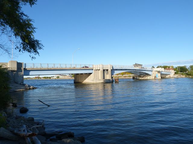
Lafayette Avenue crosses the Saginaw River by way of an island, which divides the river into two channels. This bridge crosses the east channel.
This bridge was a rare and significant example of a Scherzer Rolling lift type of bascule bridge, and was designed by the successors to the Scherzer Rolling Lift Bridge Company, Hazelet and Erdal. Unfortunately the plate girder superstructure, which would originally have been built-up with riveted construction, was demolished and replaced with a welded girder. While this welded girder simulates the shape of the original girder, the lack of rivets on the girder makes it look very plain and unattractive. It also eliminates the historic appearance of the girder. It is HistoricBridges.org's policy that complete removal and replacement of a superstructure of a historic bridge constitutes a historic bridge demolition/removal. Thus, even if elements of the substructure and bridge tender building have been retained or replicated, the bridge should not be considered a historic bridge. Had the superstructure been exactly replaced with a superstructure using built-up girders with rivets (or perhaps even bolted with rivet-simulating button-headed bolts) the bridge might be worth recognizing as a good attempt to replicate a historic bridge. However because the replacement project failed to even do this, HistoricBridges.org cannot consider this bridge to be a "historic bridge." However, despite this, the substructure and bridge tender building appear to be original, although some aspects may have been altered in 1988. As such, this webpage is intended to provide documentation of the substructure and bridge tender building, since these elements still have a small amount of historic significance.

When completed, the bridge was the recipient of an award from the American Institute of Steel Construction. Given that this award was given by a group interested in the use of steel, it is logical to assume that a primary reason for the bridge to qualify for this award was the use of a steel superstructure. Since the award-qualifying steel superstructure has been replaced, and further because the replacement superstructure fails to accurately replicate the original superstructure construction, the bridge is no longer significant as an example of an award-winning superstructure.
The original bascule bridge was designed by Hazelet and Erdal, which were the successors to the prolific and significant Sherzer Rolling Lift Bridge Company. However because the superstructure has been replaced and because the replacement does not accurately replicate the original design, it is no longer an example of this firm's work.
The substructure of this bridge and the bridge tender building both appear to include a combination of original bridge material and modern materials that do indeed appear as though they may replicate the original bridge design. Thus, the bridge might still retain some significance as an example of period architecture, since these elements do contain substantial architectural detailing.
When this bascule bridge was built, a fixed bridge was also built over the west channel of the Saginaw River. Unlike the bascule bridge, this bridge's superstructure was not replaced. Instead, it was rehabilitated and it retains excellent historic and structural integrity. It is a complete mystery why the bascule bridge could not have been rehabilitated, when the fixed west channel bridge was so beautifully preserved.
Information and Findings From Michigan Historic Bridge InventoryNarrative Description The Lafayette Avenue Bridge, located in Bay City, carries M-84/M-13 over the Saginaw River. Completed in 1938, the Lafayette Avenue Bascule Bridge is at least the second movable span built on this spot. In 1934, the highway engineers posted maximum loads for three inadequate bridges from 1 1/2 to 8 tons. Shortly after that the Lafayette Avenue Bridge was condemned, and this further focused attention to the pressing problem of bridge replacement. Unfortunately, Depression-era financing prevented any action from being taken. Finally, after a city wide bridge survey was taken in 1936, a four-point plan was devised to replace and repair the city's bridges. The program involved the immediate construction of a temporary pontoon swing span for the Lafayette Avenue structure, followed by construction of a new Lafayette Avenue Bridge, and the rehabilitation of the Belinda Street and Cass Avenue bridges. Financing help arrived in the form of Public Works Administration grants. The temporary pontoon bridge did duty over the Saginaw River for 3 1/2 years. The bridge was finished in November 1938, eleven months after construction began. The new bridge, which was awarded the A.I.S.C. award for the most beautiful moveable bridge of the year, is a Scherzer rolling lift-type with a rear break in the floor in front of the point of support with the bridge closed. Each leaf of the bridge is operated by two 25-hp motors. The lift can be opened for the passage of boats within 90 seconds. Both leaves of the bridge, as well as the traffic gates and signal, are operated from one operator's house located at the east end bascule pier. |
![]()
![]()
![]()
Coordinates (Latitude, Longitude):
Search For Additional Bridge Listings:
Bridgehunter.com: View listed bridges within 0.5 miles (0.8 kilometers) of this bridge.
Bridgehunter.com: View listed bridges within 10 miles (16 kilometers) of this bridge.
Additional Maps:
Google Streetview (If Available)
GeoHack (Additional Links and Coordinates)
Apple Maps (Via DuckDuckGo Search)
Apple Maps (Apple devices only)
Android: Open Location In Your Map or GPS App
Flickr Gallery (Find Nearby Photos)
Wikimedia Commons (Find Nearby Photos)
Directions Via Sygic For Android
Directions Via Sygic For iOS and Android Dolphin Browser
USGS National Map (United States Only)
Historical USGS Topo Maps (United States Only)
Historic Aerials (United States Only)
CalTopo Maps (United States Only)

© Copyright 2003-2024, HistoricBridges.org. All Rights Reserved. Disclaimer: HistoricBridges.org is a volunteer group of private citizens. HistoricBridges.org is NOT a government agency, does not represent or work with any governmental agencies, nor is it in any way associated with any government agency or any non-profit organization. While we strive for accuracy in our factual content, HistoricBridges.org offers no guarantee of accuracy. Information is provided "as is" without warranty of any kind, either expressed or implied. Information could include technical inaccuracies or errors of omission. Opinions and commentary are the opinions of the respective HistoricBridges.org member who made them and do not necessarily represent the views of anyone else, including any outside photographers whose images may appear on the page in which the commentary appears. HistoricBridges.org does not bear any responsibility for any consequences resulting from the use of this or any other HistoricBridges.org information. Owners and users of bridges have the responsibility of correctly following all applicable laws, rules, and regulations, regardless of any HistoricBridges.org information.
![]()