

View Information About HSR Ratings

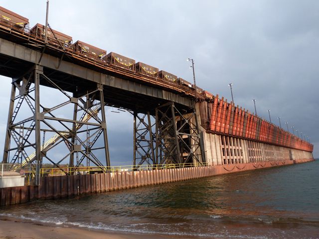
This bridge is an extremely unique structure because its purpose is to provide an approach to the historic ore dock located in Lake Superior, which is itself a rare and impressive structure that continues to function as originally designed, transferring iron ore from train cars to freighters in the lake. The bridge leads directly up to the ore dock. Both ore dock and bridge were built at the same time to replace a timber ore dock from the late 1800s. The bridge is fairly tall, which speaks to the size of the ore dock itself. The bridge itself is of generally traditional design, with deck plate girder spans supported by steel bents. However, the bridge has one unusual detail that is both attractive and serves a functional purpose. One of the bents happened to be located right where Lake Shore Boulevard runs. To deal with this, a special, wider bent with an arched opening at the base was designed to span the road and provide an opening for the road and its traffic to pass through. This solved a functional problem, but it also creates an interesting gateway for the road.

Be sure to view the historical articles for this bridge, as linked to at the top of this narrative. They contain historical photographs, details of the structure's construction, and diagrams showing how it functions.

Information and Findings From Historic American Engineering Record InventoryNarrative Description LS & I RR: PRESQUE ISLE ORE DOCK This reinforced concrete and steel dock replaced a timber dock built in 1896 and located nearby. The railroad decided in favor of this design because the estimated maintenance savings over a wooden dock outweighed the higher initial construction costs. The structure was designed by J.F. Jackson, vice president of the Wisconsin Bridge and Iron Company of Milwaukee. His firm erected the steel superstructure, while the reinforced concrete substructure, designed by R.C. Young, the chief engineer of the Lake Superior and Ishpeming Railroad, was built by the Raymond Concrete Pile Company. This was the second reinforced concrete dock built in the United States, completed a year after a similar dock was built by the Great Northern Railway at Superior, Wisconsin. Overall, it is 1,200 feet long, 54 feet wide, and rises 75 feet above the water. There are 200 ore pockets of 250 ton capacity, yielding a total storage capacity of 50,000 tons. Each pocket has a 12 foot center and is equipped with a pair of doors, each 5 feet tall and 3 feet 8 Inches wide, opening into a steel chute 35 feet long and weighing 8,200 pounds. The chutes utilized a novel design intended to prevent the ore from sticking to the chute or overflowing its confines. They were designed with curved bottoms and were tapered from 8 feet 6 inches wide at the upper end to 4 feet 6 inches at the lower end, which was inserted into the bulk ore carrier. ["Reinforced Concrete Ore Docks," Engineering News, LXIX (January 1913), pp. 8-13; LS & I RR] LS & I RR: PRESQUE ISLE ORE DOCK APPROACH (1912) The approach to the Lake Superior and Ishpeming Railroad Ore Dock (see other entry) was designed by the railroad's chief engineer, R.C. Young, with virtually all work carried out by railroad employees. It consists of an earth embankment one mile long, with a one and one-half percent grade, connected to the dock by a steel trestle 600 feet long and 70 feet in height. The base of the embankment was constructed by the Zenith Dredge Company of Duluth, Minnesota, using the material dredged from the harbor to form the slips for the dock. This base utilized approximately 100,000 cubic yards of hydraulically-filled dredgings. Work on the embankment proper began on April 3, 1911 and was completed on January 15, 1912. Crews moved a total of 503,000 cubic yards of sand from a pit one and one-half miles away, using trains of 25 sidedump cars. [Building a Large Railway Embankment," Engineering News, LXIX (February 1913), p. 299; LS & I RR] |
![]()
![]()
![]()
Coordinates (Latitude, Longitude):
Search For Additional Bridge Listings:
Bridgehunter.com: View listed bridges within 0.5 miles (0.8 kilometers) of this bridge.
Bridgehunter.com: View listed bridges within 10 miles (16 kilometers) of this bridge.
Additional Maps:
Google Streetview (If Available)
GeoHack (Additional Links and Coordinates)
Apple Maps (Via DuckDuckGo Search)
Apple Maps (Apple devices only)
Android: Open Location In Your Map or GPS App
Flickr Gallery (Find Nearby Photos)
Wikimedia Commons (Find Nearby Photos)
Directions Via Sygic For Android
Directions Via Sygic For iOS and Android Dolphin Browser
USGS National Map (United States Only)
Historical USGS Topo Maps (United States Only)
Historic Aerials (United States Only)
CalTopo Maps (United States Only)

© Copyright 2003-2024, HistoricBridges.org. All Rights Reserved. Disclaimer: HistoricBridges.org is a volunteer group of private citizens. HistoricBridges.org is NOT a government agency, does not represent or work with any governmental agencies, nor is it in any way associated with any government agency or any non-profit organization. While we strive for accuracy in our factual content, HistoricBridges.org offers no guarantee of accuracy. Information is provided "as is" without warranty of any kind, either expressed or implied. Information could include technical inaccuracies or errors of omission. Opinions and commentary are the opinions of the respective HistoricBridges.org member who made them and do not necessarily represent the views of anyone else, including any outside photographers whose images may appear on the page in which the commentary appears. HistoricBridges.org does not bear any responsibility for any consequences resulting from the use of this or any other HistoricBridges.org information. Owners and users of bridges have the responsibility of correctly following all applicable laws, rules, and regulations, regardless of any HistoricBridges.org information.
![]()