

View Information About HSR Ratings
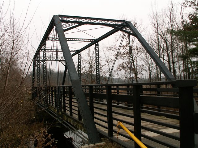
This bridge was originally located on South County Line Road over Flat River, on the border with Montcalm and Ionia Counties. On many maps however, South County Line Road is listed as Bricker Road where it crosses Flat River. The bridge was saved from demolition when it was relocated onto the Fred Meijer Heartland Trail in 1998 where it is a beautiful and functional part of the trail. "Bicyclists of Michigan" and The Dalmac Foundation contributed funds that helped preserve the bridge. The bridge is a good example of a traditionally composed pin-connected Pratt through truss bridge. Bridges like this were once common as a popular bridge type built from the late 1870s through about 1910, but thanks to demolition and replacement they are rare today.
This bridge must have been in rather poor condition when it was relocated and restored (in 1998). The portal bracing is bent up, and there are section loss holes in a couple spots on the top chord and end posts. When it was relocated, the bridge was rehabilitated. This bridge's preservation dates to before Michigan became a leader in developing metal truss bridge restoration, so less attention was paid to maintaining the historic integrity of the bridge during rehabilitation. The original American Standard Beam rolled floor beams have been replaced with modern wide-flange beams. Modern bolts were used to replace rivets in many places on the bridge. Original railings do not remain on the bridge, but those had been lost before the bridge was relocated. The bridge certainly adds a lot of interest and value to the rail-trail. The beauty and heritage of this bridge offers users of the trail so much more than would be available if the trail had installed an ugly modern mail order pre-fab truss.
This bridge is tagged with the following special condition(s): Reused
![]()
![]()
![]()
Coordinates (Latitude, Longitude):
Search For Additional Bridge Listings:
Bridgehunter.com: View listed bridges within 0.5 miles (0.8 kilometers) of this bridge.
Bridgehunter.com: View listed bridges within 10 miles (16 kilometers) of this bridge.
Additional Maps:
Google Streetview (If Available)
GeoHack (Additional Links and Coordinates)
Apple Maps (Via DuckDuckGo Search)
Apple Maps (Apple devices only)
Android: Open Location In Your Map or GPS App
Flickr Gallery (Find Nearby Photos)
Wikimedia Commons (Find Nearby Photos)
Directions Via Sygic For Android
Directions Via Sygic For iOS and Android Dolphin Browser
USGS National Map (United States Only)
Historical USGS Topo Maps (United States Only)
Historic Aerials (United States Only)
CalTopo Maps (United States Only)

© Copyright 2003-2024, HistoricBridges.org. All Rights Reserved. Disclaimer: HistoricBridges.org is a volunteer group of private citizens. HistoricBridges.org is NOT a government agency, does not represent or work with any governmental agencies, nor is it in any way associated with any government agency or any non-profit organization. While we strive for accuracy in our factual content, HistoricBridges.org offers no guarantee of accuracy. Information is provided "as is" without warranty of any kind, either expressed or implied. Information could include technical inaccuracies or errors of omission. Opinions and commentary are the opinions of the respective HistoricBridges.org member who made them and do not necessarily represent the views of anyone else, including any outside photographers whose images may appear on the page in which the commentary appears. HistoricBridges.org does not bear any responsibility for any consequences resulting from the use of this or any other HistoricBridges.org information. Owners and users of bridges have the responsibility of correctly following all applicable laws, rules, and regulations, regardless of any HistoricBridges.org information.
![]()