

View Information About HSR Ratings
In describing the history of Michigan's Signature R4 Railings, it is essential to discuss bridges on the Southfield Freeway. In 2010, a small group of Southfield Freeway overpasses were the only known surviving examples in Michigan of bridges containing an unusual variation of the R4 railing design, in which a shorter version of the R4 railings were mounted on top of a concrete parapet. With the youngest bridge on the Southfield Freeway that has these railings having been built in 1964, this R4 and parapet railing design appears to have been the final railing design that Michigan used R4 style railing panels on. No examples of bridges newer than 1964 are currently known to have been built with R4 railings on them, suggesting that 1964 may have been the final year that R4 railings were used. The R4 and parapet design seen on the Southfield Freeway overpasses seems to be suggestive of the transition to a railing design that Michigan used extensively in the 1960s and 1970s, called the tube and parapet railing, where a pipe was mounted on top of a concrete parapet as seen on the Wadhams Bridge. According to MDOT, the tube and parapet railing was first used in 1961, so there apparently was a small overlap where R4 railings were still being used, but the R4 railings were also available for bridges as well. The R4 and parapet railings seen on the Southfield Freeway Bridges were apparently something that was not commonly used nor adopted as a commonly used bridge standard. The lack of additional examples elsewhere in the state as well as the labeling of the railings in original bridge plans as "special bridge railing parapet type" seem to suggest this.
The Southfield Freeway Bridges as featured on HistoricBridges.org are not themselves very noteworthy on a technological or historical significance basis. They are a common bridge type, and having been built in the early 1960s are not very old and they do not pre-date the Interstate Highway System. However, the railings they contain are historically significant as an essential piece in documenting Michigan's bridge railing history. For this reason, these bridges appear on HistoricBridges.org.
 All
of the Southfield Freeway Bridges that retain the R4 and parapet railings
are to have their railings and decks removed and replaced with modern
railings. In a couple cases, complete demolition of the bridges will occur.
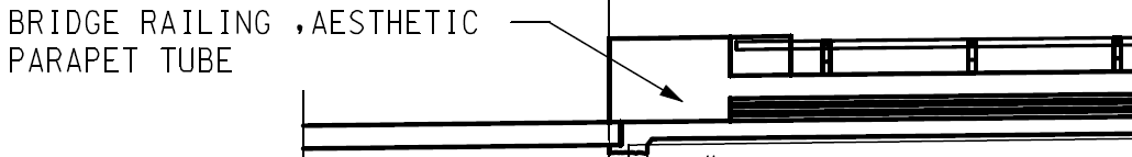
The railings which will replace the historic ones are an extremely common
type of railing used on modern bridges in urban settings in Michigan. The
railing might be described as the descendent of the R4 and parapet (and the
1960s/1970s tube and parapet) railing since it consists of a concrete
parapet with metal tube on top. However the so-called "aesthetic parapet
tube" railing is downright plain and ugly compared to the historic R4 and
parapet railings on the bridges. Why is the new railing described as
"aesthetic?" Simply because the railing has a few simple horizontal lines on
the parapet and the use of a metal tube lowers the height of barrier which
can not be seen through enhancing the view from the roadway. That such
meager attentions to the appearance of a railing qualify as "aesthetic" in
the modern transportation world shows just how far removed modern bridges
are from the concept of a "beautiful bridge." The aesthetic parapet tube is
shown in the drawing to the right, taken from MDOT bridge plan sheets for
the Southfield Freeway project.
All
of the Southfield Freeway Bridges that retain the R4 and parapet railings
are to have their railings and decks removed and replaced with modern
railings. In a couple cases, complete demolition of the bridges will occur.
The railings which will replace the historic ones are an extremely common
type of railing used on modern bridges in urban settings in Michigan. The
railing might be described as the descendent of the R4 and parapet (and the
1960s/1970s tube and parapet) railing since it consists of a concrete
parapet with metal tube on top. However the so-called "aesthetic parapet
tube" railing is downright plain and ugly compared to the historic R4 and
parapet railings on the bridges. Why is the new railing described as
"aesthetic?" Simply because the railing has a few simple horizontal lines on
the parapet and the use of a metal tube lowers the height of barrier which
can not be seen through enhancing the view from the roadway. That such
meager attentions to the appearance of a railing qualify as "aesthetic" in
the modern transportation world shows just how far removed modern bridges
are from the concept of a "beautiful bridge." The aesthetic parapet tube is
shown in the drawing to the right, taken from MDOT bridge plan sheets for
the Southfield Freeway project.
For the Southfield Freeway bridges, HistoricBridges.org would have suggested a compromise where the aesthetic parapet tube railing could be redesigned to hold the existing R4 railing panels on top instead of the default metal tube. This would have increased railing safety while retaining part of the historic railing, and would have allowed the bridges to remain unique from other Detroit area overpasses. Unfortunately, MDOT did not pursue a creative solution like that. The only good news is that the plans for the bridge projects do call for the salvage and storage of the R4 railing panels. It is presumed that these railing panels will be added to the stockpile of R4 railings that MDOT has stored for historic preservation and context sensitive bridge projects.

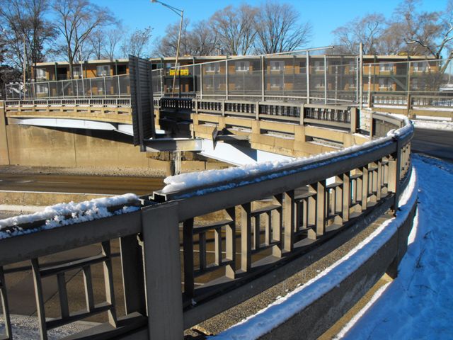
The Eight Mile Road Left Turn Bridge was built in 1964 according to the plaque and is one of the youngest of the Southfield Freeway bridges containing the R4 and concrete parapet railings. It is worth mentioning that MDOT also has bridge reconstruction plans that say the bridge was built in 1962. Perhaps the bridge was completed earlier than predicted with the plaque already made, or perhaps the bridge was begun in 1962 and not completed until 1964. Either way, despite the bridge is nevertheless by far the most historically significant example because of its unusual design and good historic integrity. The bridge was designed to allow westbound traffic on 8 Mile Road to complete a left turn onto the Southfield Freeway service road. To accommodate this purpose, the bridge was designed with the western end having a slight curve. Underneath the bridge, the stringers are arranged unusually to accommodate this. For most of the bridge, the stringers run straight across the bridge like normal. But on the southwest corner, the southernmost stringer beam terminates and is connected with a bracket to another beam that runs at a more southward angle to the abutment. Short stringers then run from the abutment to this southward angled stringer. The Eight Mile Left Turn Bridge retains is R4 and concrete parapet railings on the bridge as well as the approach. The bridge also has an attractively curved abutment and approach railing section on the southeast corner. Unlike on other bridges, some of the R4 railings, specifically those on the approach, are unobstructed by cyclone fence and so the HistoricBridges.org photo-documentation of this railing design is the best with this bridge.

The 2011 project for this bridge will remove and replace the historic railings. In addition, the project is unusual because although it replaces the above-ground portions of the pier (which has some serious and obvious deterioration), it reuses the stringers, as well as the below-ground portion of the pier. All of the heritage value of the bridge will be lost in this project however.

Information About This Bridge From MDOT Bridge PlansThe W33 rolled steel beam existing structure was built In 1962 and was designed for HS20-S16-44 loading. The 126'-8 1/4 " long 2 span bridge has a clear roadway width of 24'-0". The bridge was repainted in 1996. |
![]()
![]()
![]()
Coordinates (Latitude, Longitude):
Search For Additional Bridge Listings:
Bridgehunter.com: View listed bridges within 0.5 miles (0.8 kilometers) of this bridge.
Bridgehunter.com: View listed bridges within 10 miles (16 kilometers) of this bridge.
Additional Maps:
Google Streetview (If Available)
GeoHack (Additional Links and Coordinates)
Apple Maps (Via DuckDuckGo Search)
Apple Maps (Apple devices only)
Android: Open Location In Your Map or GPS App
Flickr Gallery (Find Nearby Photos)
Wikimedia Commons (Find Nearby Photos)
Directions Via Sygic For Android
Directions Via Sygic For iOS and Android Dolphin Browser
USGS National Map (United States Only)
Historical USGS Topo Maps (United States Only)
Historic Aerials (United States Only)
CalTopo Maps (United States Only)

© Copyright 2003-2024, HistoricBridges.org. All Rights Reserved. Disclaimer: HistoricBridges.org is a volunteer group of private citizens. HistoricBridges.org is NOT a government agency, does not represent or work with any governmental agencies, nor is it in any way associated with any government agency or any non-profit organization. While we strive for accuracy in our factual content, HistoricBridges.org offers no guarantee of accuracy. Information is provided "as is" without warranty of any kind, either expressed or implied. Information could include technical inaccuracies or errors of omission. Opinions and commentary are the opinions of the respective HistoricBridges.org member who made them and do not necessarily represent the views of anyone else, including any outside photographers whose images may appear on the page in which the commentary appears. HistoricBridges.org does not bear any responsibility for any consequences resulting from the use of this or any other HistoricBridges.org information. Owners and users of bridges have the responsibility of correctly following all applicable laws, rules, and regulations, regardless of any HistoricBridges.org information.
![]()