

View Information About HSR Ratings
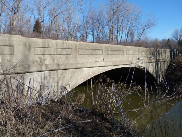
This bridge is a structure with an interesting history. This bridge was originally built as a concrete arch bridge. The year given by the National Bridge Inventory for construction is 1925. Based on the design of the bridge and in particular its railings, it appears this may have been built by the Illinois Bridge Company of Chicago. In 1956, the bridge was apparently becoming too narrow for the needs of traffic on the road. As a result a three span concrete slab was built on the north side of the bridge as a way to create a wider bridge. This required the removal of the concrete arch's railing on the north side. The new railing was located at the northern side of the new concrete slab. The concrete slab design, including the railing, conforms to a standard design that the Wayne County Road Commission had developed during World War II. The concrete slab design used less steel (scarce during the War) than other bridge types like a steel stringer. The design apparently served the road commission well, and they continued to use the design into the 1950s, as demonstrated here.
Normally, such an alteration diminishes the significance of a historic bridge like this concrete arch bridge. However it is worth noting that some of Wayne County's concrete slab bridges that follow the design seen in the added structure on Vreeland Road have been been considered for listing in the National Register of Historic Places since they document the development of bridge design work in the Wayne County Road Commission, which was a nationwide leader in the development of highway and bridge technology. Additionally, this concrete arch bridge together with the added concrete slab illustrates one of the major selling points for concrete arch bridges back in the day when they were constructed. When reinforced concrete arch bridges were first coming into the market in the first decade of the 20th Century they were the subject of much discussion as to what their benefits might be. Bridges like metal pony and through truss bridges and metal through girders were common bridge types during this time. Advocates, like noted bridge engineer Daniel B. Luten, who patented concrete bridge designed and ran companies to build concrete bridges were aggressive supporters and proponents of concrete arch bridges. Literature and advertisements they produced proclaimed the glory of concrete bridges while condemning metal truss and girder bridges. Luten usually described truss and girder bridges as "temporary bridges" that would not stand the test of time and would develop problems and concrete bridges as "permanent bridges" that would last forever and could adapt to changing times. In the Journal of the Western Society of Engineers, September 1912 Vol. 17 No. 7, Luten described his concept of the "Ideal Highway Bridge" as needing to meet a series of requirements, which of course, his concrete bridges would meet. He described one of the requirements as follows:
10. Widened Roadway. The standard width of highway bridges in the middle western states is now 16 ft.; in many southern states 12 ft. is customary; in eastern states 24 ft. has become quite usual. As a community grows older, it frequently becomes necessary to widen bridges to provide for increasing traffic that could not have been foreseen, or that would have required excessive cost in the original construction. It sometimes occurs that a bridge is erected with a 16 ft. roadway, and that later the coming of an interurban railway builds up the community about the bridge, necessitating a structure of much wider roadway. Through bridges of truss or girder type cannot ordinarily be widened without scrapping the superstructure. If the supporting steel trusses or girders were originally heavy enough to carry the additional load, which, of course, is rarely the case, they can be moved apart and supplied . with heavier floor beams. But the through girder of concrete cannot be widened and since its only advantage is large waterway, it is limited by the necessity for a shallow floor system, to a road· way width of 16 ft. or 18 ft. Hence it can hardly be considered a permanent bridge in any sense except in a locality that is at a standstill in population or value. The extended use of such a bridge by any community is a standing advertisement of lack of progress in population, wealth and road improvement, for since it has not even the excuse of low cost to commend it, and is intended to be a permanent bridge, it signifies lack of faith in any future growth. Deck bridges and arches can be widened at any time without loss of any of the original investment except moving the railing and possibly burying the spandrel walls in the added fill.
Today, the ability to widen a modern bridge is taken for granted since the design of today's bridges are usually simple beam type bridges of some sort, and they can be widened by simply adding beams to either side of the bridge. However, when concrete arch bridges were introduced, this idea was something new. Common during this time were metal truss bridges, which were usually of the pony or through design, and metal through girders were also common. These bridges are generally not possible to widen because the structure of the bridge, the truss or girder, would have to be completely moved and placed at the edge of the widened bridge, at which point it likely would no longer be massive enough to support the load of a wider deck. The concrete arch bridge presented a new opportunity, where the bridge could be widened without having to affect or alter the arch bridge, with the minor exception of removing the railings to open to wider deck up.
If the Vreeland Road Bridge had been built as a truss bridge, it would not be here today because it would have been completely replaced. But thanks to the design of a concrete arch bridge, it was able to adapt to increased traffic, become part of a wider bridge, and as a result the bridge remains here today. The concrete arch next to the Wayne County Road Commission standard concrete slab is also a vivid demonstration of the evolution of bridge design.
![]()
![]()
![]()
Coordinates (Latitude, Longitude):
Search For Additional Bridge Listings:
Bridgehunter.com: View listed bridges within 0.5 miles (0.8 kilometers) of this bridge.
Bridgehunter.com: View listed bridges within 10 miles (16 kilometers) of this bridge.
Additional Maps:
Google Streetview (If Available)
GeoHack (Additional Links and Coordinates)
Apple Maps (Via DuckDuckGo Search)
Apple Maps (Apple devices only)
Android: Open Location In Your Map or GPS App
Flickr Gallery (Find Nearby Photos)
Wikimedia Commons (Find Nearby Photos)
Directions Via Sygic For Android
Directions Via Sygic For iOS and Android Dolphin Browser
USGS National Map (United States Only)
Historical USGS Topo Maps (United States Only)
Historic Aerials (United States Only)
CalTopo Maps (United States Only)

© Copyright 2003-2024, HistoricBridges.org. All Rights Reserved. Disclaimer: HistoricBridges.org is a volunteer group of private citizens. HistoricBridges.org is NOT a government agency, does not represent or work with any governmental agencies, nor is it in any way associated with any government agency or any non-profit organization. While we strive for accuracy in our factual content, HistoricBridges.org offers no guarantee of accuracy. Information is provided "as is" without warranty of any kind, either expressed or implied. Information could include technical inaccuracies or errors of omission. Opinions and commentary are the opinions of the respective HistoricBridges.org member who made them and do not necessarily represent the views of anyone else, including any outside photographers whose images may appear on the page in which the commentary appears. HistoricBridges.org does not bear any responsibility for any consequences resulting from the use of this or any other HistoricBridges.org information. Owners and users of bridges have the responsibility of correctly following all applicable laws, rules, and regulations, regardless of any HistoricBridges.org information.
![]()