

View Information About HSR Ratings
2017 news update about these bridges: These bridges are not going to be demolished, but the use of some of these bridges is going to change, in a unique project that will allow these historic prototypical interchanges to play a role in another type of prototypical development in transportation: autonomous and connected vehicles. In January 2017, Lloyd Baldwin, Historian for Michigan Department of Transportation provided the following details about the future of these bridges as follows: MDOT is partnered with the American Center for Mobility, which is developing a connected vehicle test facility on the site of the former Ford Willow Run Bomber Plant. The ACM will use a portion of WB US-12, between Wiard Road and the east tri-level, for high speed vehicle testing and will utilize . MDOT will shift WB traffic to the EB roadway, with minor modifications to the midlevel structures of the west and east tri-level. No work is currently programmed for the lower levels and upper levels of the tri-levels. Any such work would be conducted by the ACM. ACM will, despite using private funds, be required to conduct full NEPA compliance. Section 106 consultation was conducted. SHPO concurred that the tri-level structures retain adequate historical integrity to remain NRHP eligible. The proposed work poses no adverse effect. SHPO did not agree that the roadways were NRHP eligible due to the demolition of all but a small portion of the bomber plant.
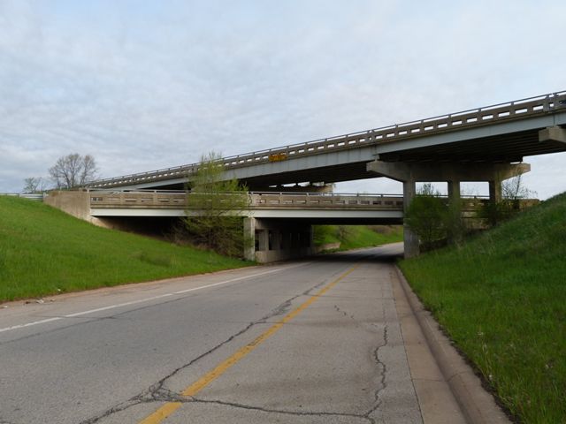
This interchange is one of two similar three level interchanges which are both historically significant for their association with World War II B-24 bomber production at the Willow Run Plant, (having been created to serve the needs of the factory) and technologically significant as surviving interchanges from Michigan's first substantial limited access highway system. The information boxes from the historic bridge inventory and Michigan Historic Sites Online below provide a more in-depth view of the significance of these interchanges.
Dimensions shown on this page are for the larger third level bridge in this interchange. Download the NBI Data Sheet for a full breakdown of both bridges. The interchanges have been designated a National Register of Historic Places Historic District. It is interesting to note that although dating to 1942 and predating the Interstate Highway System by over ten years, these interchanges are a more efficient design of interchange than some of the interchanges built in later decades on the Interstate Highway System. The interchanges are three level interchanges that provide for a "T" intersection of highways. As a three level interchange, flyover ramps are provided, which eliminates the slow, inefficient cloverleaf design that would be seen in a two level interchange, although it does so with the sacrifice of greater construction cost. Ironically, in later years, Michigan established itself as a proponent of the less expensive cloverleaf interchanges, constructing them in significant quantities and only using interchanges with multiple levels and flyovers sparingly. For example, the I-69 Business Loop interchange with I-69 in eastern Clinton County was built in 1985, and although it is the same sort of intersection of highways, it uses a two level cloverleaf design with no flyovers. The design speed for the ramp with the cloverleaf is lower than the equivalent flyover ramp on this 1942 interchange.
Today, the interchange survives with the ramp and interchange configuration having excellent historic integrity. The bridges themselves have fair historic integrity. The original railings have been replaced. The original piers have also been replaced, but they appear to have been replaced in-kind and they appear to retain the correct architectural detailing, as well as the unique shared pier design where one pier supports two bridges. The upper level bridge is of interest because it has a larger span with built-up beams over the second level overpass bridge. The other spans leading up to this span are shorter spans with rolled stringer beams. These spans have beams that are not as deep as a result. This design, with deep beams providing a span over the highway, and approach spans having shallower beams is unusual in Michigan but is remarkably similar to the design of bridges on freeways in Pennsylvania.
Information and Findings From Michigan Historic Bridge InventoryThe four bridges comprising the Willow Run Tri-level
Grade Separation Historic District are eligible for the National
Register as significant components of the expressway system developed
during World War II to serve the Willow Run bomber plant. The B-24
aircraft produced at the facility were considered vital to the nation's
defense. The bridges are also eligible under the category of Engineering
as a creative solution to the massive volume of traffic anticipated when
shifts changed at the bomber plant. Information About Willow Run Bomber Plant From Michigan Historic Sites OnlineArchitect/Builder Albert Kahn WILLOW RUN (1941-1953) After entering World War II in 1941, America desperately needed military equipment and supplies. The Ford Motor Company had begun building this factory in April 1941. Outstanding industrial architect Albert Kahn designed Willow Run, one of the largest manufacturing plants under one roof in the world. Completed in early 1942, this bulwark of the "Arsenal of Democracy" produced 8,685 B-24 Liberator Bombers and had a peak employment of 42,000 men and women. After the war, the newly formed Kaiser-Frazer Corporation--in an unsuccessful effort to create a large-scale automotive empire--occupied this plant. Here the company manufactured the first of 739,039 passengers cars, as well as military aircraft. In 1953, Kaiser-Frazer transferred its diminishing operations from Willow Run to Toledo, Ohio, and Argentina. WILLOW RUN (1953-PRESENT) "Willow Run" initially referred to the small stream running through this area. The name then identified the bomber factory, airport, and community which sprung up around the wartime industry. Now this Willow Run plant is the General Motors Hydra-matic Division, makers of automatic transmissions. First based in Detroit, this division moved to Livonia where fire destroyed its facilities on August 12, 1953. That September General Motors transferred the Hydra-matic operations to Willow Run. Twelve weeks after the fire, transmissions again rolled off the totally retooled and rearranged assembly line--an amazing feat of industrial efficiency. This factory has known both war and peace. Continuing to make transmissions, the plant also manufactured military hardware during the Korean and Vietnam conflicts. Willow Run reflects the versatility of the auto industry. |
![]()
![]()
![]()
Coordinates (Latitude, Longitude):
Search For Additional Bridge Listings:
Bridgehunter.com: View listed bridges within 0.5 miles (0.8 kilometers) of this bridge.
Bridgehunter.com: View listed bridges within 10 miles (16 kilometers) of this bridge.
Additional Maps:
Google Streetview (If Available)
GeoHack (Additional Links and Coordinates)
Apple Maps (Via DuckDuckGo Search)
Apple Maps (Apple devices only)
Android: Open Location In Your Map or GPS App
Flickr Gallery (Find Nearby Photos)
Wikimedia Commons (Find Nearby Photos)
Directions Via Sygic For Android
Directions Via Sygic For iOS and Android Dolphin Browser
USGS National Map (United States Only)
Historical USGS Topo Maps (United States Only)
Historic Aerials (United States Only)
CalTopo Maps (United States Only)

© Copyright 2003-2024, HistoricBridges.org. All Rights Reserved. Disclaimer: HistoricBridges.org is a volunteer group of private citizens. HistoricBridges.org is NOT a government agency, does not represent or work with any governmental agencies, nor is it in any way associated with any government agency or any non-profit organization. While we strive for accuracy in our factual content, HistoricBridges.org offers no guarantee of accuracy. Information is provided "as is" without warranty of any kind, either expressed or implied. Information could include technical inaccuracies or errors of omission. Opinions and commentary are the opinions of the respective HistoricBridges.org member who made them and do not necessarily represent the views of anyone else, including any outside photographers whose images may appear on the page in which the commentary appears. HistoricBridges.org does not bear any responsibility for any consequences resulting from the use of this or any other HistoricBridges.org information. Owners and users of bridges have the responsibility of correctly following all applicable laws, rules, and regulations, regardless of any HistoricBridges.org information.
![]()