

View Information About HSR Ratings
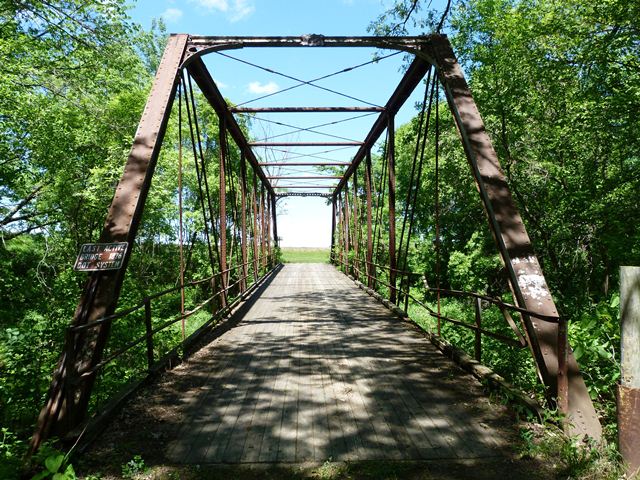
This bridge is the oldest highway Pratt truss in Minnesota. It has been relocated twice in its life. It was originally built over the Blue Earth River just south of Vernon Center in Blue Earth County. In 1928, the bridge was replaced and was reused as a highway over trunk highway overpass, carrying CR-102 over MN-22 in Kasota Township (La Sueur County). More recently, some time after its listing in the National Register of Historic Places in 1981, it was relocated to its current location in Washington Park.
Built in the 1870s when iron bowstring truss bridges were all the rage in highway construction, this pin-connected Pratt truss was a few years ahead of when this bridge type was most common. Bowstrings died out almost completely and almost immediately after 1880, allowing pin-connected Pratt truss bridges to become the dominant form of metal highway bridge. As a bridge built in 1975, it has a lot of unusual, non-standard details that was typical of bridges built before 1880. These include most unusual struts that are composed of plate rolled and riveted together to form a tube. The portal bracing is ornately designed of cast iron. The bridge has unusual cast iron feet that act as bearings and also attachments for lateral bracing. The cast iron plaques on the bridge portals frustratingly only lists a construction date. Although this bridge's distinctive portal bracing and struts undoubtedly were the unique production of a particular bridge company, no other known examples of bridges with these details exist, so it is not possible to associate a builder based on style at this time. Future research might reveal a builder however.
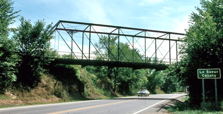
Above: This photo from the Minnesota Historical Society shows the bridge in its second location as an overpass.
![]()
![]()
![]()
To access this bridge, drive straight down the park road and stop near where it dead ends. Walk back behind the building in the grass and follow the treeline until you reach the bridge.
Coordinates (Latitude, Longitude):
Search For Additional Bridge Listings:
Bridgehunter.com: View listed bridges within 0.5 miles (0.8 kilometers) of this bridge.
Bridgehunter.com: View listed bridges within 10 miles (16 kilometers) of this bridge.
Additional Maps:
Google Streetview (If Available)
GeoHack (Additional Links and Coordinates)
Apple Maps (Via DuckDuckGo Search)
Apple Maps (Apple devices only)
Android: Open Location In Your Map or GPS App
Flickr Gallery (Find Nearby Photos)
Wikimedia Commons (Find Nearby Photos)
Directions Via Sygic For Android
Directions Via Sygic For iOS and Android Dolphin Browser
USGS National Map (United States Only)
Historical USGS Topo Maps (United States Only)
Historic Aerials (United States Only)
CalTopo Maps (United States Only)

© Copyright 2003-2024, HistoricBridges.org. All Rights Reserved. Disclaimer: HistoricBridges.org is a volunteer group of private citizens. HistoricBridges.org is NOT a government agency, does not represent or work with any governmental agencies, nor is it in any way associated with any government agency or any non-profit organization. While we strive for accuracy in our factual content, HistoricBridges.org offers no guarantee of accuracy. Information is provided "as is" without warranty of any kind, either expressed or implied. Information could include technical inaccuracies or errors of omission. Opinions and commentary are the opinions of the respective HistoricBridges.org member who made them and do not necessarily represent the views of anyone else, including any outside photographers whose images may appear on the page in which the commentary appears. HistoricBridges.org does not bear any responsibility for any consequences resulting from the use of this or any other HistoricBridges.org information. Owners and users of bridges have the responsibility of correctly following all applicable laws, rules, and regulations, regardless of any HistoricBridges.org information.
![]()