

View Information About HSR Ratings
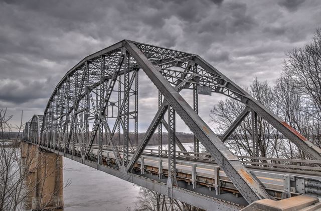
This bridge is noted among large river bridges for its long-span simple truss spans, with no continuous or cantilever design. Its riveted Pennsylvania truss configuration is also uncommon. The bridge was designed by noted firm Harrington, Howard and Ash. One of the spans collapsed during construction and had to be rebuilt. See photo below.

This is a beautiful, historic, large river bridge. The lead agency in charge of the bridge is Missouri Department of Transportation. That means the bridge didn't stand a glimmer of a chance to be preserved. This bridge has been sentenced to the scrapyard, to be replaced by a ugly modern bridge with no beauty, character, or heritage. Sadly, there isn't much more to say than this, after over 10 years of watching MoDOT decimate what was once the largest collection in the country of large river truss bridges (Missouri River and Mississippi River Bridges) down to a sliver of what it once was, it is clear that even the few historic truss bridges which remain will not receive any more consideration for preservation despite their increased rarity due to past demolitions. Some other states with poor preservation track records, such as Pennsylvania, have slowly improved their efforts to preserve bridges after years of efforts on the part of preservationists to effect change. However, in Missouri these efforts have been completely fruitless. While both Pennsylvania and Missouri are guilty of demolishing some of the finest historic bridges in the country, Missouri stands out as the greater disappointment because even now at the final opportunities to save the last few bridges remaining, there is absolutely no interest whatsoever to save even a sliver of these historic bridges. Just a never ending complaints about the narrow width of these bridges, and the cost of maintenance. These complaints make no sense. A one-way couplet of bridges could provide two wide lanes of traffic and redundancy in case one bridge needs to be closed for repairs. As for cost of maintenance this also makes no sense, since other states and countries in this world maintain truss bridges without all the complaining about cost. If the bridge costs too much to maintain, its probably because it wasn't being maintained as well as it should have been. Deferring needed repairs increases overall cost. Repairs should be made as soon as deterioration is detected. Missouri would do well to look at how the state of Michigan maintains bridges like the Mackinac Bridge, Blue Water Bridge, etc. This level of maintenance represents the best use of taxpayer dollars in the long run. Soon it won't matter however, soon all of these bridges will be gone forever. And then the public will get to see how long these so-called wonderful modern bridges REALLY last. Future generations could face enormous costs if MoDOT's precious modern pre-stressed concrete bridges prove to be less long-lasting than they are advertised to last by the well-paid engineers who sell them to the public.
It is perhaps fitting that the photo-documentation took place under very gloomy skies that cast a depressing grey over everything the camera lens was aimed at. Even more fitting, some of the best photos and views of this bridge were had from a cemetery.


Above: Historical advertisement for the bridge, provided by Brent Freesmeyer.
![]()
![]()
![]()
This historic bridge has been demolished. This map is shown for reference purposes only.
Coordinates (Latitude, Longitude):
Search For Additional Bridge Listings:
Bridgehunter.com: View listed bridges within 0.5 miles (0.8 kilometers) of this bridge.
Bridgehunter.com: View listed bridges within 10 miles (16 kilometers) of this bridge.
Additional Maps:
Google Streetview (If Available)
GeoHack (Additional Links and Coordinates)
Apple Maps (Via DuckDuckGo Search)
Apple Maps (Apple devices only)
Android: Open Location In Your Map or GPS App
Flickr Gallery (Find Nearby Photos)
Wikimedia Commons (Find Nearby Photos)
Directions Via Sygic For Android
Directions Via Sygic For iOS and Android Dolphin Browser
USGS National Map (United States Only)
Historical USGS Topo Maps (United States Only)
Historic Aerials (United States Only)
CalTopo Maps (United States Only)

© Copyright 2003-2024, HistoricBridges.org. All Rights Reserved. Disclaimer: HistoricBridges.org is a volunteer group of private citizens. HistoricBridges.org is NOT a government agency, does not represent or work with any governmental agencies, nor is it in any way associated with any government agency or any non-profit organization. While we strive for accuracy in our factual content, HistoricBridges.org offers no guarantee of accuracy. Information is provided "as is" without warranty of any kind, either expressed or implied. Information could include technical inaccuracies or errors of omission. Opinions and commentary are the opinions of the respective HistoricBridges.org member who made them and do not necessarily represent the views of anyone else, including any outside photographers whose images may appear on the page in which the commentary appears. HistoricBridges.org does not bear any responsibility for any consequences resulting from the use of this or any other HistoricBridges.org information. Owners and users of bridges have the responsibility of correctly following all applicable laws, rules, and regulations, regardless of any HistoricBridges.org information.
![]()