

View Information About HSR Ratings

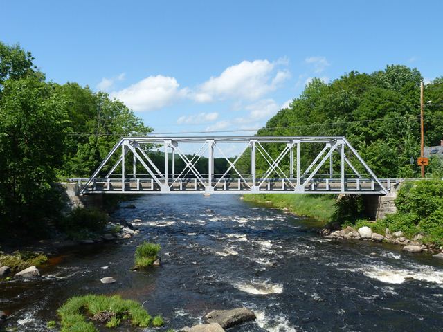
This bridge is an attractive, traditionally composed example of an early 20th Century through truss. It was designed by the firm of Storrs and Storrs, which was based out of Concord, New Hampshire and apparently was a well-known firm for bridge work in New England. The senior member of this firm, John Williams Storrs, was also noteworthy as the first state highway engineer for New Hampshire. Groton Bridge Company, also a well-known bridge builder that was prolific in the northeastern United States, constructed the bridge.
This bridge was rehabilitated in 2001 and it remains in excellent condition today. There was some alteration during rehabilitation, most noteworthy the replacement of the bottom chord and the replacement of the floor beams. The bottom chord was replaced in kind, however bolts were used instead of rivets, as apparently was the case elsewhere on the bridge where rivets were removed.
This bridge is noted for being in close proximity to another historic truss bridge built around 15 years later, the Western Avenue Bridge. The Western Avenue Bridge appears to have been built to carry US-202, as an improved alignment for traffic heading southbound/northbound in this area. It eliminates a 90 degree turn that would be needed if using Patterson Hill Road Bridge. As such, this likely reduced the traffic on Patterson Hill Road Bridge, making it more of a local traffic bridge.


![]()
![]()
![]()
Coordinates (Latitude, Longitude):
Search For Additional Bridge Listings:
Bridgehunter.com: View listed bridges within 0.5 miles (0.8 kilometers) of this bridge.
Bridgehunter.com: View listed bridges within 10 miles (16 kilometers) of this bridge.
Additional Maps:
Google Streetview (If Available)
GeoHack (Additional Links and Coordinates)
Apple Maps (Via DuckDuckGo Search)
Apple Maps (Apple devices only)
Android: Open Location In Your Map or GPS App
Flickr Gallery (Find Nearby Photos)
Wikimedia Commons (Find Nearby Photos)
Directions Via Sygic For Android
Directions Via Sygic For iOS and Android Dolphin Browser
USGS National Map (United States Only)
Historical USGS Topo Maps (United States Only)
Historic Aerials (United States Only)
CalTopo Maps (United States Only)

© Copyright 2003-2024, HistoricBridges.org. All Rights Reserved. Disclaimer: HistoricBridges.org is a volunteer group of private citizens. HistoricBridges.org is NOT a government agency, does not represent or work with any governmental agencies, nor is it in any way associated with any government agency or any non-profit organization. While we strive for accuracy in our factual content, HistoricBridges.org offers no guarantee of accuracy. Information is provided "as is" without warranty of any kind, either expressed or implied. Information could include technical inaccuracies or errors of omission. Opinions and commentary are the opinions of the respective HistoricBridges.org member who made them and do not necessarily represent the views of anyone else, including any outside photographers whose images may appear on the page in which the commentary appears. HistoricBridges.org does not bear any responsibility for any consequences resulting from the use of this or any other HistoricBridges.org information. Owners and users of bridges have the responsibility of correctly following all applicable laws, rules, and regulations, regardless of any HistoricBridges.org information.
![]()