

View Information About HSR Ratings
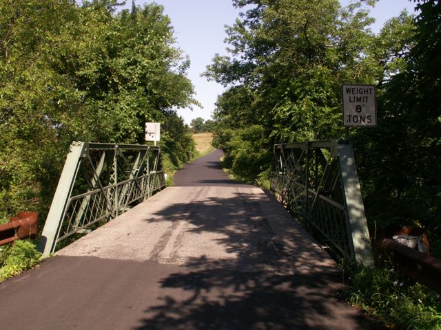
This bridge is a heavily altered example of Wrought Iron Bridge Company's unique pony truss design, which features their characteristic bolt connection detail at the top chord / end post connection area. Sadly, it is difficult to see the details of this bridge because large metal bars were welded to this bridge to act as diagonals, bypassing the pin connected diagonals.
This bridge has lost historic significance as a result of these alterations.
However it is worth noting that the original truss bridge itself, is noteworthy because it displays the distinctive and unusual details of its builder.
Information and Findings From New Jersey's Historic Bridge InventoryDiscussion of Bridge The skewed 3-panel traditionally composed Pratt half hip pony truss bridge is pin-connected. Cast iron end post connections are used at the top and bottom chords. It is supported on random ashlar abutments and wingwalls. Welded additions include duplicate diagonals and bottom chord members and plates added to panel points. Although a documented bridge with an interesting detail, alterations have compromised the integrity and technological significance of the bridge. More complete examples exist. Discussion of Surrounding Area The bridge carries one lane of a lightly traveled country road over a minor stream. It is located in a wooded rural setting near open fields and sparse housing. Bridge Considered Historic By Survey: No |
![]()
![]()
![]()
Coordinates (Latitude, Longitude):
Search For Additional Bridge Listings:
Bridgehunter.com: View listed bridges within 0.5 miles (0.8 kilometers) of this bridge.
Bridgehunter.com: View listed bridges within 10 miles (16 kilometers) of this bridge.
Additional Maps:
Google Streetview (If Available)
GeoHack (Additional Links and Coordinates)
Apple Maps (Via DuckDuckGo Search)
Apple Maps (Apple devices only)
Android: Open Location In Your Map or GPS App
Flickr Gallery (Find Nearby Photos)
Wikimedia Commons (Find Nearby Photos)
Directions Via Sygic For Android
Directions Via Sygic For iOS and Android Dolphin Browser
USGS National Map (United States Only)
Historical USGS Topo Maps (United States Only)
Historic Aerials (United States Only)
CalTopo Maps (United States Only)

© Copyright 2003-2024, HistoricBridges.org. All Rights Reserved. Disclaimer: HistoricBridges.org is a volunteer group of private citizens. HistoricBridges.org is NOT a government agency, does not represent or work with any governmental agencies, nor is it in any way associated with any government agency or any non-profit organization. While we strive for accuracy in our factual content, HistoricBridges.org offers no guarantee of accuracy. Information is provided "as is" without warranty of any kind, either expressed or implied. Information could include technical inaccuracies or errors of omission. Opinions and commentary are the opinions of the respective HistoricBridges.org member who made them and do not necessarily represent the views of anyone else, including any outside photographers whose images may appear on the page in which the commentary appears. HistoricBridges.org does not bear any responsibility for any consequences resulting from the use of this or any other HistoricBridges.org information. Owners and users of bridges have the responsibility of correctly following all applicable laws, rules, and regulations, regardless of any HistoricBridges.org information.
![]()