

View Information About HSR Ratings
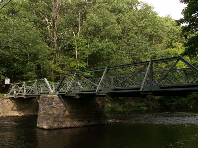
This bridge is one of Hunterdon County's unusually large population of multi-span pony truss bridges. Multi-span pony trusses are uncommon in other parts of the country, where single span pony trusses are usually the only type of pony truss commonly found, with most multi-span truss bridges being through trusses.
The bridge has been altered with numerous welded additions to the bridge, but as a multi-span pony truss, it retains a degree of significance on a nationwide scale.
A little westbound down the road from the truss bridge is a tiny, but historically intact, attractive stone arch bridge. This bridge is not listed in the National Bridge Inventory, because it is under 20 feet in length and thus not considered a bridge by NBI.
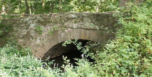
Stone arch bridge a little westbound down the road from the bridge.
Information and Findings From New Jersey's Historic Bridge InventoryDiscussion of Bridge The traditionally composed pin-connected half hip Pratt pony truss is two spans, each 4 panels. It is supported on random stone abutments and a pier. Lattice railings remain. The bridge has been significantly modified. Welded additions include plates at panel points, reinforcing of the lower chords, repair plates on diagonals, and outriggers. On two panels the floorbeams are hung from the top chord using bolts and hangers. The span is too altered to be technologically significant. Discussion of Surrounding Area The bridge carries one lane of a lightly trafficked unimproved rural road over the South Branch of the Raritan River. It is located in a well preserved wooded setting that includes a camp and a nature preserve. Bridge Considered Historic By Survey: Yes |
![]()
![]()
![]()
Coordinates (Latitude, Longitude):
Search For Additional Bridge Listings:
Bridgehunter.com: View listed bridges within 0.5 miles (0.8 kilometers) of this bridge.
Bridgehunter.com: View listed bridges within 10 miles (16 kilometers) of this bridge.
Additional Maps:
Google Streetview (If Available)
GeoHack (Additional Links and Coordinates)
Apple Maps (Via DuckDuckGo Search)
Apple Maps (Apple devices only)
Android: Open Location In Your Map or GPS App
Flickr Gallery (Find Nearby Photos)
Wikimedia Commons (Find Nearby Photos)
Directions Via Sygic For Android
Directions Via Sygic For iOS and Android Dolphin Browser
USGS National Map (United States Only)
Historical USGS Topo Maps (United States Only)
Historic Aerials (United States Only)
CalTopo Maps (United States Only)

© Copyright 2003-2024, HistoricBridges.org. All Rights Reserved. Disclaimer: HistoricBridges.org is a volunteer group of private citizens. HistoricBridges.org is NOT a government agency, does not represent or work with any governmental agencies, nor is it in any way associated with any government agency or any non-profit organization. While we strive for accuracy in our factual content, HistoricBridges.org offers no guarantee of accuracy. Information is provided "as is" without warranty of any kind, either expressed or implied. Information could include technical inaccuracies or errors of omission. Opinions and commentary are the opinions of the respective HistoricBridges.org member who made them and do not necessarily represent the views of anyone else, including any outside photographers whose images may appear on the page in which the commentary appears. HistoricBridges.org does not bear any responsibility for any consequences resulting from the use of this or any other HistoricBridges.org information. Owners and users of bridges have the responsibility of correctly following all applicable laws, rules, and regulations, regardless of any HistoricBridges.org information.
![]()