

View Information About HSR Ratings
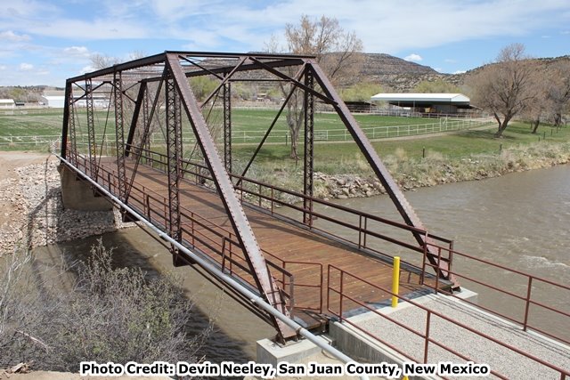
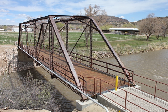
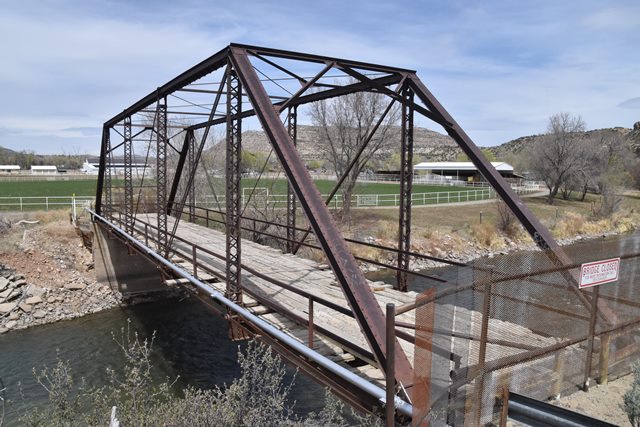
The Cedar Hill Bridge carries Road 2380 over the Animas River in San Juan County, New Mexico. The bridge is historically significant as a rare surviving example of its type in New Mexico as well as the entire Mountain States region of America. The bridge is also significant for its lack of alteration, and even moreso for its very remarkable lack of deterioration in its steel.
The truss structure of the Cedar Hill Bridge is remarkable for the lack of rust-related deterioration of its steel materials. This may be due to the dry climate of the region, which has greatly limited the bridge's exposure to moisture and rain, and the bridge's location on a rural road where corrosive winter deicing salts and chemicals likely have never been in use. Nearly all the steel on the bridge could only be described as "like new." It appears that the bridge was never painted, indicating that this bridge has avoided deterioration by virtue of its location and material properties alone. Moreover, it appears that when the bridge was erected, mill scale survived on the bridge, and, in a number of areas, this mill scale remains in place and visible today. Typically, if a bridge was erected over 100 years ago and it had mill scale on it when erected, one would expect that time and weather would have removed all traces of it by today, which is what makes the Cedar Hill Bridge remarkable. Its unusual lack of deterioration also manifests itself in the sharp edges of all the steel on the bridge which have not worn down, and the easily legible steel mill name on the channels. The floorbeams of this bridge even have surviving hand-painted part and job numbers on them which appear to date to the original fabrication and erection of the bridge.
The builder of the bridge is not known. The bridge was reportedly constructed shortly after floods in 1911 devastated area bridges. The rolled channels display "Illinois 2." The "Illinois" refers to Illinois Steel which had become part of United States Steel (USS) in 1904. Until the 1950s, USS continued to roll steel bearing the former company name of the particular mill rolling the steel. Most steel with "Illinois" was followed by a "G" or "S" (referring to respectively to the Gary, Indiana Works and the South Chicago Works). Illinois steel with a "2" after the name is extremely rare on bridges, and the meaning of the "2" is unclear, but may refer to a designation for a particular steel mill.
The superstructure and deck of the Cedar Hill Bridge is composed of the following details: end posts and upper chord: back-to-back channels with cover plate and v-lacing; verticals: back-to-back channels with v-lacing on each side; bottom chord: up-set eyebars; diagonal members: up-set eyebars; counters: loop-forged rods with turnbuckles; portal bracing: traditional a-frame design composed of angle; upper and lower lateral bracing: threaded rod; sway bracing: paired angles; floorbeams: rolled American Standard beams; deck stringers: six rows of rolled American Standard beams, plus two fascia channels; deck: timber; railing: two channels mounted to truss vertical members. The bridge has riveted pin plates, which also function as hangers that are bolted to the floorbeams. The truss displays a historical technique used in fabrication shops to produce cutouts of small sections of steel, such as the ends of vertical member channel flanges to make room for eyebar heads. Rather than use a cutting torch or other modern equipment, a series of small holes would be successively drilled in a row to cut the section of material. The use of this technique is readily recognizable by the sawtooth appearance of the area that was cut. The bridge sits on a concrete substructure. The northern end of the bridge has a simple concrete abutment which extends down to the river. A large horizontal crack in this abutment appears to indicate that the abutment was constructed in two concrete pours. The south abutment in contrast is a short section of concrete which rests upon a large rock outcrop along the river.
Immediately west and parallel to the bridge is an irrigation flume which carries water over the Animas River. This flume structure is a pin-connected truss composed of members that are similar to those used in the highway bridge, but it has a significantly different overall configuration and appearance because it was purposely designed to serve as a flume. The flume itself is quite unusual and may have individual historic significance. It also compliments the architectural appearance of the highway truss bridge.
As of 2024, this historic bridge has been restored and preserved for non-motorized traffic. The steel restoration work was completed by Bach Steel of St. Johns, Michigan, and all other repair work was completed by TRC Construction of Flora Vista, New Mexico. San Juan County deserves to be thanked for this outstanding committment to preserving its transportation heritage!
![]()
![]()
![]()
![]()
![]()
Coordinates (Latitude, Longitude):
Search For Additional Bridge Listings:
Bridgehunter.com: View listed bridges within 0.5 miles (0.8 kilometers) of this bridge.
Bridgehunter.com: View listed bridges within 10 miles (16 kilometers) of this bridge.
Additional Maps:
Google Streetview (If Available)
GeoHack (Additional Links and Coordinates)
Apple Maps (Via DuckDuckGo Search)
Apple Maps (Apple devices only)
Android: Open Location In Your Map or GPS App
Flickr Gallery (Find Nearby Photos)
Wikimedia Commons (Find Nearby Photos)
Directions Via Sygic For Android
Directions Via Sygic For iOS and Android Dolphin Browser
USGS National Map (United States Only)
Historical USGS Topo Maps (United States Only)
Historic Aerials (United States Only)
CalTopo Maps (United States Only)

© Copyright 2003-2024, HistoricBridges.org. All Rights Reserved. Disclaimer: HistoricBridges.org is a volunteer group of private citizens. HistoricBridges.org is NOT a government agency, does not represent or work with any governmental agencies, nor is it in any way associated with any government agency or any non-profit organization. While we strive for accuracy in our factual content, HistoricBridges.org offers no guarantee of accuracy. Information is provided "as is" without warranty of any kind, either expressed or implied. Information could include technical inaccuracies or errors of omission. Opinions and commentary are the opinions of the respective HistoricBridges.org member who made them and do not necessarily represent the views of anyone else, including any outside photographers whose images may appear on the page in which the commentary appears. HistoricBridges.org does not bear any responsibility for any consequences resulting from the use of this or any other HistoricBridges.org information. Owners and users of bridges have the responsibility of correctly following all applicable laws, rules, and regulations, regardless of any HistoricBridges.org information.
![]()